On the Road In Much Wenlock ~ ‘A Rip Van Winkle Kind Of A Place’

Much Wenlock Sheinton Street towards Holy Trinity Church

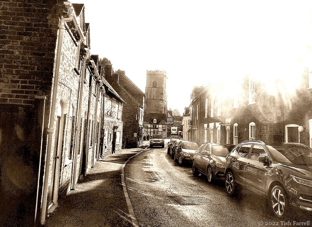
Sheinton Street looking towards Holy Trinity Church

*

It’s a while since I posted any photos of my home town. These shots are all from the archive, but I had a notion to edit them in sepia tones, along with a touch of over-exposure here and there to accompany  the century-old quotation from Shropshire writer Mary Webb. I mean to say, even with all the cars, it still has that  look. There’s definitely a sense of Winkle time-slippage. This may well have something to do with the fact that this small town has been continuously occupied for  more than a thousand years. And before that, there would have been Romans and Romano-British wandering around the place with the likelihood of a villa/bathhouse on the site of the medieval Wenlock Priory. And before that, itinerant Bronze Age smiths may well have passed through, one of whom lost his stash of arrow and axe heads in the River Severn not far from Wenlock. Or maybe it was a donation for a safe crossing.

Many of the facades you see in the photos have been added on the front of much earlier buildings – this during periods of particular market-town prosperity when there were attempts at gentrification. I say ‘attempts’ because by all accounts even in the late nineteenth century there was a smelly open sewer running through the town. Also the place was regularly doused in limestone dust with every blasting at surrounding quarries. And there would have been some evil smog too from lime burning kilns (this to produce lime for building mortar and fertiliser).

Much Wenlock High Street

Looking down on the High Street

*

Much Wenlock The Bullring

The Bull Ring where once  the popular sport of bull baiting took place on fair days and holidays

*

Much Wenlock The Square

The Square (looking past the church towards Wilmore and Sheinton Street)  with the Museum on the left (once the Butter Market and then a cinema) and the 16th century Guidhall opposite. The assizes were held on the upper floor, the lock-up down below. These days the town council holds its meetings there.

*

Much Wenlock Queen Street

Queen Street and Brook House Farm, one of the last surviving town farms, now ‘done up’ into several desirable residences. I remember it with cattle in the barn.

*

Much Wenlock High Street with Reynalds Mansion

The High Street featuring our star timber-framed residence – Reynolds Mansion, a fifteenth century hall with a grand 1682 frontage

*

Much Wenlock High Street towards Gaskell Corner

Top of the High Street. This row of stone clad cottages contains some very ancient inner parts.

*

Much Wenlock High Street and Wilmore Street with Guildhall

Much Wenlock Sheinton Street towards New Road

Looking down Sheinton Street from the Farrell house

*

Much Wenlock lane beside Priory ruins

Downs Lane beside Wenlock Priory

*

Related: Wenlock: “A Rip Van Winkle kind of a place

Cee’s Black & White Photo Challenge: roads

Over The Home Hill: More Hills

P1050952ed2

Wenlock Edge behind our house runs for twenty odd miles, a wooded escarpment that bisects the county of Shropshire on a north-east-south-west axis. It’s not always easy to see out for the tree cover, but here and there, a few choice viewpoints give you a glimpse of Shropshire’s other hills, the Long Mynd living up to its name in the distance here. I’m fumbling for the name of the hill in the middle distance (not recognising it from this angle). It could be Caradoc.

*

If we turn right round in the other direction, then we can see Clee Hill:

P1050963ed

*

Closer to home, you can take the National Trust footpath out of Much Wenlock and head for the Edge landmark, Major’s Leap, from where, on a winter’s day, you may be treated to an other-worldly view of the Wrekin, subject of many quaint Shropshire tales. (My version here).

IMG_1949ed

*

And coming down the Edge footpath behind our house you have a fine view of Much Wenlock hugged round by hills, Walton Hill and Shirlett Forest:

IMG_1373ed

*

And while I’m showing off our local hills, I can’t leave out the town’s favourite landmark: Windmill Hill with a small turquoise person heading over it:

P1030046ed

Lens-Artists: over the hill  Donna at Wind Kisses has set this week’s challenge.

Stranger Than Fiction

P1080542ed

And Shropshire’s Stiperstones with its brooding Devil’s Chair outcrop has indeed provided the setting for several works of fiction: the novels of Mary Webb, Malcolm Saville’s still popular Lone Pine adventure stories for children, and also D.H. Lawrence’s novella St. Mawr. And naturally, given its dramatic looks, it also features in local myths and legends, particularly those associated with Wild Edric, the Saxon earl who refused to surrender his lands to the Norman invaders and stirred up rebellion, allying himself with the Welsh princes of Gwynedd and Powys just over the border.

In real life it is an utterly strange place. These photos were taken on a summer’s day, but somehow, when we reached the hilltop, the light leached away. Even so, the grey-white quartzite outcrops seemed to have an unsettling luminosity.  The photos I took using the monochrome setting on my camera are especially other worldly. There also appears to be an odd patch of mist on the next photo. I can’t explain it.

P1080574ed

P1080557ed

*

And in colour, too, the landscape’s disturbing presence is scarcely diminished:

P1080552ed

*

Lens-Artists: Surreal This week Tracy challenges us to post some surreal images, and believe me, she has her own very original take on the topic. Go see for yourselves.

On The Ice-Sheet Path ~ Stiperstones Revisited

IMG_0542ed

This time we approach from the west, the Shropshire border with Wales below and behind us.  The path from The Bog climbs up through sheep pasture hedged with gorse. The gold is dazzling. In sun-sheltered hollows, out of the wind, the flower-mass gives off coconutty scents. The grassland too is flushed with gold – a mass of buttercups.

After a steepish climb, the path sets off more evenly along the foot of the Stiperstones ridgeway, the quartzite tors of Cranberry Rocks and Manstone Rock standing proud on the skyline. We are making for the Devil’s Chair (header photo), but it is still invisible at this point along the path.

IMG_0515re

The tors’ rubble spill  (stone runs) makes them look more like man-made spoil heaps than natural phenomena. And of course this was an industrial landscape across nearly two millennia:  from Roman times to the early 20th century. Although back then the activity was mostly hidden from sight in the deep mine shafts and caverns dug for the extraction of valuable lead ore.

The tors, though, are their own work, their response to environmental pressures – the fractured tumble created by the freeze-thaw cycles of the last glaciation when the Welsh ice sheet nudged up against the hillside, but did not cover it. In fact, as we follow the path, we must be walking over terrain where the ice would have lain feet deep, the far edge below the tors ebbing in surface melt-water in summer, resuming the deep-freeze lock-down in winter.

It’s surely not too hard to imagine?

For as we walk here under the sun, the bright gorse and lush new bilberry bushes, bleating of lambs, distant mew of a buzzard, I note that even now in late May, the wind still has a piercingly icy edge.

It reminds me, too, that for some reason most of us have decided, on the basis of nothing in particular, that the planet has somehow done with ice ages; that they must be a thing of the past. Yet the last ice sheets only retreated 10,000 years ago; we are presently in an interglacial, the Holocene.

IMG_0527re

Within interglacial periods there are phases of warming and cooling. E.g. It is generally accepted that around 6,000 years ago that the northern hemisphere was much warmer (Holocene thermal maximum) than it is today (NOAA National Oceanic & Atmospheric Administration US). There is likewise evidence from analysis of pollen and other prehistoric deposits in peat bogs across Europe of  periods of dramatic climatic decline e.g. the Late Bronze Age Britain (from around 3,000 years ago) when it became much wetter and cooler. Yet by the time the Romans had taken over the land, there was another warm phase. And again in the Medieval period, this before the general descent into the Little Ice Age of 14th-19th centuries for which there are also historical accounts. (I mentioned the London Frost Fairs of the Little Ice Age in a recent post on chaotic weather.)

The cycle of ice ages and climatic variation within interglacial phases is apparently dependent on shifts in the inclination of the earth on its axis, plus associated so-called ‘wobbles’, together with variations in the sun’s energy output. In other words, there can be  no doubting that here we have in play planetary cycles that are stratospherically beyond humanity’s capacity to control. Anyway, it’s making me think that hanging on to the woolly jumpers and thermal underwear might not be a bad idea.

And talking of woolly jumpers, as the Devil’s Chair comes into view I find myself the subject of ovine scrutiny…

IMG_0532re

IMG_0533re

*

And now for the Devil’s Chair, long the subject of Shropshire myth and witchery:

IMG_0540ed

*

And the view from this spot, back towards Cordon Hill, the border and Wales. Remember that ice sheet. This was the land that it covered. At the glacial maximum around 22,000 years ago the ice was estimated to be up to half a kilometre deep. Sheffield University has produced some interactive maps.

IMG_0545re

IMG_0546re

The dark tussocks are heather which will bloom in late summer. The bright green bushes are bilberries, locally called win- or wimberries – our native version of blueberries, ready to pick around August time, but presently flowering. The little rosy bells are hard to see, but the bees are finding them:

IMG_0555re

*

As we retrace our steps to The Bog where we’ve left the car, I’m stopped in my tracks by  the sight of a mountain ash tree seedling. There it is, growing so strongly atop a weathered gate post. It makes me smile. It seems like a sign: the earth, the real world, has much to teach us when we choose to pay attention.

IMG_0559ed

Corvedale In Late April

IMG_0389re1

Driving up and out of Wenlock yesterday and suddenly all of Corvedale  stretched before us. And so much of it YELLOW!

And so it seems that despite a wild and windy spring, followed by the last two weeks of dry and chilly weather, the oil seed rape is blooming. Its heady scent filled the car as we headed to The Crown at Munslow for a family lunch. The fields of it were everywhere, filling our sights as we rounded bend after bend on the narrow lane, shocking the vision at every turn. Then to the south, there was Clee Hill, rising serenely above a lemony sea. It made us wonder what Van Gogh might have made of this landscape, or if in fact the crop is having the last word: that there is little more to be said about yellow. IMG_0387re

Long Mynd Wrought By 600 Million Years Of Earth Change

P1030457cr

This sheep is posing on some of the world’s most ancient rocks, layers of mud-stones, sand-stones and shales laid down when this incipient Shropshire Hill was still lying in shallow seas somewhere in the Indian Ocean off East Africa. This was followed by much shunting and shifting across the planet, tectonic plates smashing and colliding.

Our most local collision was along the Church Stretton Valley, just over Wenlock Edge, some twelve miles from where we live. To the east of it (some 600 million years ago) volcanic ash and lava formed our well loved hills of Wrekin, Lawley, Caer Caradoc and Ragleth. To the west lay the sedimentary formations of Long Mynd, which around 550 million years ago were folded and thrust upwards along the Church Stretton Fault.

Then in recent times (2.4 million to 20,000 years ago) glaciers slipped and slid along the  Mynd’s flanks, although the summit was clear of ice. And then during successive interglacial (warming) periods (300,00-15,000 years ago) melting ice fed stream torrents that cut deep valleys and batches…

P1030461resized

P1030466resixws

P1100539res

Ashes Hollow, one of the Mynd’s stream-cut batches

*

And so it might be timely to ponder on the momentous natural forces that brought about the formation of this single Shropshire hill – begun in tropical seas half a world away, then wrought by collision, compression, ice and melt-water. And all achieved without the meddling of humanity and on a planet that is endlessly reshaping itself.

100_4415

View from the Long Mynd’s Carding Mill Valley towards Ragleth Hill

*

P1080522resized

Looking east from the Long Mynd towards the Wrekin

*

Lens-Artists: Earth Story    Please visit Amy to see her very stunning Earth Story photos.

Don’t look now, but there’s a man in the tree…

IMG_0186cr

Monday morning. Sunshine after days of rain plus hints of spring.  A walk to the shops then. We set off down the Cutlins field path, pleased to find it dry underfoot, though we’re pleased too soon: at the path bottom by the kissing gate we find a huge puddle.  Ah well. Muddy shoes AGAIN. There are strange sounds too, out on the lane, shattering the peace of the Priory ruins. Chainsaws.

When we reach the Priory Hall (originally a National School that once served Much Wenlock’s poor children, but now is the town’s community centre), this is the sight that greets us. Goodness.

Then we recall the recent planning application. The line of  lime trees along the churchyard wall behind the Priory Hall has been scheduled to be taken in hand – three cut down and the remaining ones pruned. Better get a better look then. It’s not often that Much Wenlock provides so much excitement on a Monday morning:

IMG_0191cr

IMG_0189cr

IMG_0193cr

IMG_0197cr

IMG_0199cr

IMG_0207cr

Lens-Artists: Close and closer

Rocks, boulders, Stiperstones

P1080542cr

Shropshire’s mysterious Stiperstones featured in a recent Square Odds post. Here are more shots in monochrome, plus a few facts for geology lovers.

The grey-white rock of the ridge is quartzose sandstone known as the Stiperstones Quartzite Formation, created some 480 million years ago in the Ordovician era.

The tors and the rubble-like surroundings we see today are the work of more recent events in the last Ice Age (c. 115,000 – c. 11,700 years ago).  During this time, the eastern edge of the Welsh ice sheet was nudged up against the Stiperstones, not covering it,  but causing the quartzite to fracture during periods of intense freezing followed by thawing.

The highest point (Manstone Rocks) is 536 metres (1,759 ft) above sea level, making it the county’s second tallest hill after Brown Clee.  The ridge extends some 8 kilometres (5 miles), the summit crowned with a series of six distinctive outcrops.

For geology buffs there is a detailed overview of Shropshire’s 700 million year geological history by Peter Toghill HERE.

This next photo: men on Manstone Rock, the highest point on the Stiperstones…

P1080557cr

P1080558cr

P1050991cr

P1060001cr

Cee’s Black & White Photo Challenge: rocks, boulders, stones

The Wenlock Poppy Bomb

P1050072cr

One mid-summer evening when I was leaving the allotment by the gate rather than by my usual route through the field hedge, I glimpsed, on the far edge of town, over rooftops, and between trees, an astonishing scarlet blaze where I’d never seen one before. Home was forgotten, and off I went to investigate: over the main road out of Wenlock and down a lane beside the old railway bridge, into a field with an abandoned barn by the gate, and there it was: an entire field of poppies.

They looked to have exploded from an oil seed rape crop, but it was hard to tell. Had someone sabotaged the farm seed, or did the farmer do it on purpose? Whatever the cause, it’s not happened since. But it was one of those weirdly wonderful happenings wherein it was hard not to grow very over-excited and run amok. I took lots of happy snaps, then dashed home to spread the news to he had a much smarter camera. And then we went back and repeated the excitement, all fuses fired by poppy power.

P1050070cr

101_0340cr

101_0335cr

101_0335header

The Square Odds #14

And Another Shropshire Ghost

100_7053cr

In an earlier post this week I mentioned Wild Edric our heroic Saxon warlord who challenged the Norman interlopers and ended up as a ghost haunting the Stiperstones. Now shunt forward a few hundred years to the 1640s, a time when England was locked in civil war: Roundhead Parliamentarians versus Charles 1 and the Royalist army. The Parliamentarians were intent on curbing the king’s proclivities to do as he liked at the nation’s expense; the Royalists were set on protecting the monarch’s prerogative.

We’ve shifted from the South Shropshire hills to Wenlock Edge, a wooded limestone escarpment that rears up above the county’s farming lowland for nearly 20 miles. Enter one Major Thomas Smallman, fleeing on horseback from his home in nearby Wilderhope Manor. He is a King’s man, carrying despatches for the Royalist headquarters in the county town of Shrewsbury, some dozen miles away. On his heels are Cromwell’s troops. Trying to evade them, the major veers off along the Edge. But there’s no escape. He and horse leap over the precipice. It is a two hundred foot drop. The major was caught up in a crab apple tree, and so survived to deliver his despatches to Shrewsbury, but his valiant horse was lost. Perhaps that’s why a ghostly major on horseback may sometimes be glimpsed near this signpost on the Edge footpath.

100_7053

*

And to give you a notion of what lay before the major when his horse took off:

100_7057res

The Square Odds #10