
The grand mansion was ever built to impress and raise social standing, its setting in the landscape deploying all manner of visual knacks and contrivances to enhance imposing looks. See, it says, this is the domain of the rich and powerful, beings who inhabit a realm far removed from that of ordinary mortals.
And to prove this point, it was not unknown for mansion owners to dispatch from their purview, and place elsewhere, the unsightly villages of their peasant tenants. It was common, too, to incorporate tunnels and hidden thoroughfares in the surrounding grounds so as not to suffer the indignity of looking out from the drawing room windows and seeing a passing labourer.
Sometimes one does wonder why we British never had a revolution.

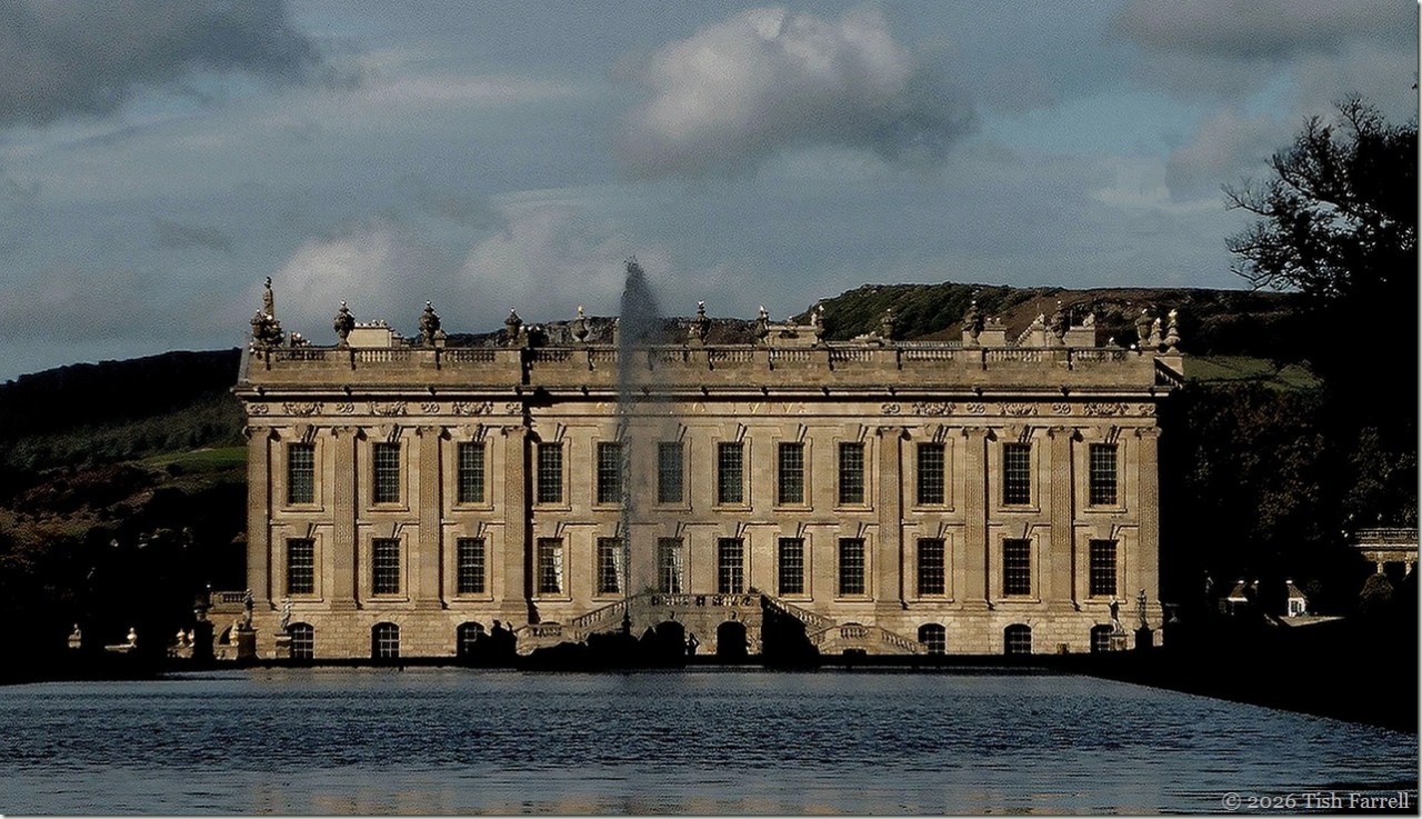
Here at Chatsworth in Derbyshire, seat of the Dukes of Devonshire, generations of the Cavendish family have spared no expense when it comes to home and garden improvements. (It is still the family’s home, albeit now the Chatsworth House Trust).
The first house here was built in the 1550s by Elizabeth Talbot (widow of Sir William Cavendish who amassed great wealth during the Dissolution of the monasteries), otherwise known as Bess of Hardwick, Countess of Shrewsbury. She built a large Tudor mansion on the banks of the River Derwent, which in later times acquired the Classical finish we see today, complete with elaborate gold leaf embellishments (recently restored across the entire exterior by the Chatsworth House Trust).
Yes, all those windows in the header photo, and more besides, have gilded frames since real gold is said to provide the best weather protection.
On the stately homes tourist trail, Chatsworth is among Britain’s most popular visitor attractions, this despite the £33 adult entry ticket. The gardens and park are perhaps what return visitors love most, the Emperor Fountain (header) and the Cascade (coming next) being among the more spectacular favourites. (Note too the ride cut through the trees on the far hill, to mirror the Cascade and add to the expansiveness of the parkland setting).


The first version of the Cascade was built in the 1690s by French hydraulics engineer, one Monsieur Grillet, who had worked for Louis XIV. In succeeding years it was doubled in length, widened, made steeper and repositioned to align with the southern frontage of the house. The contrived waterfall is fed from water draining from the high moors into a series of lakes above Chatsworth, and then descends through some 60 metres, just under 200 feet.
These days it is out of commission, waiting for 7-million-pounds’ worth of repairs. Over half of this sum has already been awarded by the National Heritage Lottery Fund, but members of the public are also being urged to sponsor one of the hundred stones that make up the 23 steps, the suggested donations ranging from £100-£500.

Meanwhile, the grandeur of the interior might also render one speechless. This is the Painted Hall, created in 1694 by Louis Laguerre. Actually, when we visited a few years ago, it simply made me very cross. Much of the wealth of the Dukes of Devonshire (and before them the Earls of Shrewsbury) derived from tithes and rents from their farm and lead miner tenants who inhabited communities on their land holdings across Derbyshire’s High Peak District. Among them were generations of my maternal Fox and Bennett ancestors. So it makes me think, looking at such unbridled opulence; family tales have it that, as a girl, my great grandmother, Mary Ann Fox, used to ride over to Chatsworth from Callow Farm, at Highlow, to deliver the family’s tithe in eggs.**

The photo above shows the library. We were only allowed to look through the open doors. And this is but one of very many extravagantly furnished rooms and apartments . (See the State Apartments HERE) So how does one gain perspective on the scale of wealth disposed for the single purpose of showing off? What did successive dukes and duchesses see if they caught sight of themselves in one of their many grand mirrors?

Enough. I’ll finish with a much more pleasing view out in the garden. A soothing avenue of young beech trees, moderately uncontrived, in late summer light:

And a view of the River Derwent that flows below Chatsworth. Upstream it passes through fields once farmed by the Fox family at Callow Farm. They had to sell up in 1892. The rents were by then too high to make a living.

**To Chatsworth and how Mary Ann went to the ball
Copyright 2026 Tish Farrell
Lens-Artists: Perspective, Depth, Scale This week John shows us different tools in photo composition. Go see!