
Taken a few winters ago. This year we’ve only had frost. So far.

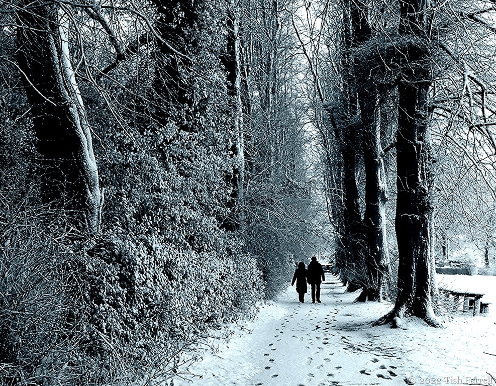
Taken a few winters ago. This year we’ve only had frost. So far.
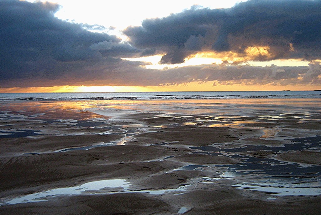

As I may have mentioned, once or several times, the January winds during our recent trip to Anglesey were vicious; not only the fearsome bluster but also the endless fusillade of icy darts that penetrated every ill protected piece of flesh. But they could not be avoided. My sister’s cockapoo needed walks, and coming equipped with built-in woolly suit, she did not give a fig for gales and freezing sea pools. If anything, they spurred her on: much racing and paddling and digging. It was hard not find such energy and all-round canine joy infectious. And then when we reached the beach beyond the dunes and estuary, there were sights like this: Celtic Sea sundowner; next stop Ireland. Tempest or not, how could this be missed. It had been so long since we’d seen and smelled the sea.
We weren’t the only ones to feel excited:


Farrell Safaris are notorious for their cross-country deviations even when kitted out with a fully functioning map. And so it was on our recent Anglesey stay, and with an intended short (couple of miles) drive from Aberffraw to next-door Rhosneigr, that we managed to miss the turn and instead head off to who knew where.
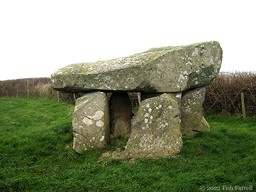
Usually when this happens, Captain Farrell’s first resort is to keep going, perhaps in hopes that, if we do this for long enough, all will come right. Fortunately this time we had savvy niece in the back seat, and she soon had our position pinpointed on her phone. We did indeed need to turn around. And it was while this was going on – i.e. finding a suitable turning space on a narrow country lane, that I spotted the Neolithic burial chamber in the far corner of a farm field.
Can we stop, says me, hoping for a better look over the wall and maybe a long-shot photo (poor light willing).
But once turned about, we soon saw that a proper visit was feasible. There were official signs in Welsh and in English ‘Ty-Newydd Burial Chamber’, a pull-in space on the verge and a stile. Sister, cockapoo and niece were up for a visit, though the wind was brutal and it was starting to rain. In my rush to head the expedition as chief prehistorian I was ensnared in a hawthorn bush and held up proceedings. Meanwhile Captain Farrell gathered himself for unscheduled activity, and manfully brought up the rear.
We then tramped across the muddy field only to find the ancient capstone (a whopping 12 ft by 5ft/3.7 m by 1.5m) had been propped up on two unsightly brick pillars set on a concrete base. And while their solid intervention was doubtless necessary for many reasons, their presence jarred. The dreary light did not help.

*
So it turned out that the original drive-by view had been more impressively mysterious than the close-quarters’ encounter. Ah well.


*
The tomb was excavated in 1935 and is considered typical of the funerary monuments built by the first farming people (see also the Barclodiad y Gawres tomb in an earlier post). Finds included a hearth with charcoal remains, some flint flakes, a burned flint arrow head, and a chip from a polished stone axe. But there were also pottery shards of the later Beaker People of the Bronze Age, and signs of a further chamber, which suggest the tomb was used, or re-used over a considerable time-span. The large cairn that once covered the tomb is long gone – ploughed out and/or its stones re-purposed. Instead, small concrete bollards have been set out to indicate its original extent. Useful guidance on the one hand, but like the brick supports, they felt intrusive somehow.
Anyway, we paid our respects to ancient souls who then, like us, must have been alarmingly blasted by the training jets taking off at nearby RAF Valley. The New Year’s holiday was over and ‘business as usual’ resumed. Out of the gale the engines’ roar filled the sky, the earth, the universe, my skull. It was noise so loud as to be physically shattering. I had that strange sense of someone walking over my grave and a horrid glimpse of what it must to be some innocent village dweller in a war zone; to be on the receiving end of the northern hemisphere’s mighty industrial war machine.
Several times during that day the soundtrack for Armageddon rebounded through my bones and being. It happened again in late afternoon as we walked on Aberffraw’s magnificent beach. And I wondered then, as I have done many times recently, what on earth the ancestors would think of us now. We who believe ourselves so very civilised?

A Hawk T1 or T2 (?) caught over Aberffraw estuary. And the photos taken immediately afterwards – first looking towards mainland Wales, and the second across the Celtic Sea towards Ireland:


Lens-Artists: interesting things
This week Patti wants to see the kinds of scenes/objects that catch our eye or pique our interest. Please go and view her interesting choices.
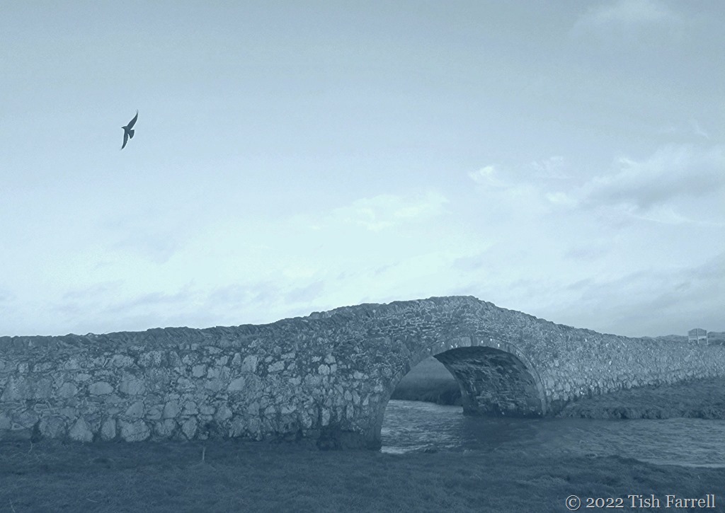

This seventeenth century packhorse bridge in the Anglesey village of Aberffraw is quite a landmark and much photographed (on sunny summer days). You can see why it catches the photographer’s eye, but on a bleak and windy January day, I’m thinking it’s the local jackdaw that adds a certain something to the scene.
There was also a jackdaw ‘fly-by’ when I visited the village church, another of Anglesey’s ancient places of worship, St Beuno’s. As with ‘the little church in the sea’ in the previous post, parts of it date from the 12th century.

It was by no means the earliest church in Aberffraw. That was built some five centuries earlier by St. Beuno himself, though no traces of his work remain. As with many early Christian places of worship it was probably a simple thatched and timber-framed structure that would leave few signs of itself. But in their time, both these churches probably served as royal chapels to the Princes (and Princesses) of Gwynedd who in the early Middle Ages held court close by. Their palace likewise left little trace of its existence, having been dismantled and its parts dispersed after England’s King Edward I invaded Wales (1277-1282). Although I did read that it was discovered belatedly that the village council houses had been probably been built over the site. The way things change!
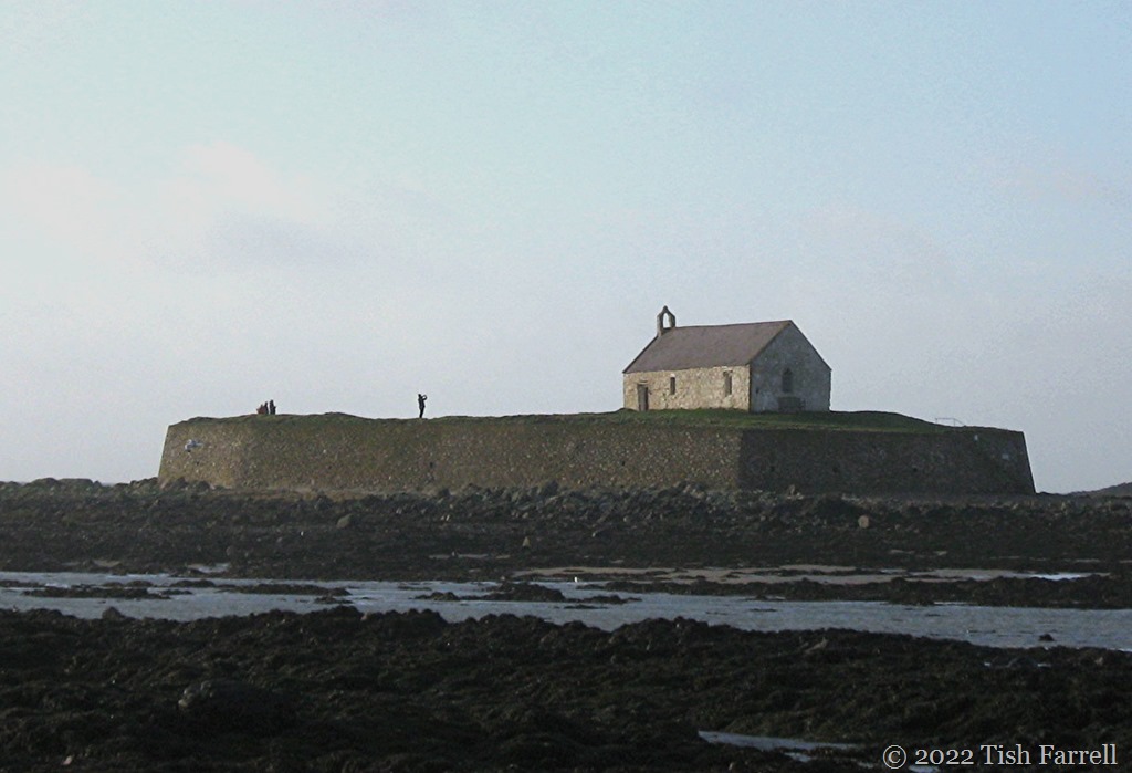

Or in Welsh: Eglwys bach y môr. Dating from the 12th century, it survives the sea storms only with the help of some robust 19th century defences. Erosion has reduced the peninsula on which it was originally built to a tidal island known as Cribinau. You can find it along the Coastal Path just north of Aberffraw (Anglesey).
The church itself is dedicated to the Irish Saint Cwyfan (Kevin) who lived in the 6th century. Whether he ever visited Anglesey is not known, but the island, once the stronghold of the Celtic Druids until the Roman invasion, was certainly a favoured retreat for early Christian hermit-saints.
You can walk across to the island at low tide and the church is still used for weddings and christenings. Come a bright summer’s day, it would be hard to imagine a more momentous setting for such important family rites.


It sits on the westerly headland above Anglesey’s Porth Trecastell Bay, a Neolithic passage grave known as Barclodiad y Gawres (the ‘Giantess’s Apronful’). It was built around 5,000 years ago by local farming people whose only tools were made of stone and wood and bone. It comprises a stone passageway more than twenty feet long, and in the centre a once high-domed chamber with apses, cruciform in plan, the whole covered with a mound of turves. Over the millennia the superstructure weathered and, as happened with most prehistoric remains, many of the stones were robbed and repurposed, doubtless still lodging in field walls, gateways, barns and farmsteads.
But recycling episodes apart, archaeologists excavating in the 1950s were able to discover much about the original monument. Their findings in turn informed the reconstruction of both the mound and tomb entrance that visitors see today. You can also go inside, but only so far. An iron gate has been installed to protect the main chamber, the key to it only available in summer from the Spar shop in nearby Llanfaelog.
Not to be thwarted, I took this photo through the bars.

*
Bone of frog and shrew and hare and grass snake…
So what did the archaeologists find? First there were the cremated remains of two young males. Then there was the central chamber hearth and within it the bony parts of wrasse (a marine fish), eel, frog, toad, shrew, grass snake, mouse and hare, the lot covered in a layer of limpet shells and pebbles. A potent brew however you look at it. Then there are the carved stones, designs pecked away with a stone chisel: chevrons, spirals and zigzags in a style seen in other Neolithic passage graves across the Celtic Sea in Ireland, or further afield in Brittany and Portugal. Clearly the Neolithic settlers on Anglesey came from voyaging stock.
And then there was the pollen grain evidence discovered beneath the mound. This suggested that far from the largely tree-less landscape we see today, the coastal terrain, when the tomb was built, was well wooded. And so we have a glimpse of another phenomenon: how prehistoric farming folk set about changing the landscape, often dramatically so.
Today, much of Anglesey comprises un-treed arable fields and sheep pasture. The boundary trees and hedges that do survive are blasted into submission by sea-gales, as were we last week when we struggled along the cliff to pay homage to the ancestors.


P.S. Incidental info: Porth Trecastell beach is also known as Cable Bay. In 1902 it was here that one of the island’s Atlantic telegraphic cables was laid, connecting to Ireland in the first instance, and thence to the United States. Needless to say, the connection has long been abandoned. The other cable ran from Porth Crugmor and aeons ago as a child, I remember being taken to see it by my parents. They seemed so sure I would find the visit edifying, excited themselves by this piece of historic submarine communication. I only recall the rusting hawser affair running out along the beach and finding its determined westward progression into the sea and beneath the waves very disturbing.
For more photos outside and inside the tomb: http://www.megalithics.com/wales/barclody/barcmp.htm


We have just returned from a week away in the tiny coastal village of Aberffraw on the North Wales island of Anglesey. It was two years since we were last on Ynys Môn, the island’s Welsh name, and we had all missed it. It is a special place, not least because it is a land rich in ancient remains. In the past, too, it was rich in other ways – at times its wealth of farm produce making it the bread basket of Britain.
From the time the Romans left Britain to the early Middle Ages when England’s Edward I set about hammering the Welsh by means of obsessive-compulsive-castle-building, Aberffraw was a major seat of Welsh power. For eight centuries (from AD 450 to AD 1282) it was here that the kings of Gwynedd held their royal court and ruled North Wales. They saw off Viking raiders and Norman interlopers. They had their glory days under Llywelyn ap Iorwerth (AD 1173 – 1240), who was recognised as ruler of all Wales. This period of prosperity appears to have coincided with the Medieval warm period, a time of clement weather and of good harvests. This was all to change in the next century (1314-1317) when a period of prolonged winters and high-storm weather began, and brought with it the Great Famine.

It’s a stark lesson – how fortunes rise and fall and entire communities, landscapes and weather patterns transform, the cycles of change we humans often find hard to accept or credit. When Edward invaded Anglesey, he dismantled the palace at Aberffraw and repurposed the stone and timber in his own strongholds. And then in 1331 came ‘the great storm’ that blew up monumental quantities of sand that covered the inland fields and began the silting of the River Ffraw, which action reduced the once vibrant port to a backwater. Gone was the busy fishing harbour. Gone the trade with the great sailing ships that once put in there to take on local produce.
In 1949 Aberffraw was reckoned amongst the poorest places in Wales. Today there are just over 600 residents; less than three quarters of whom are native Welsh speakers. Many of the old cottages are holiday lets. (We six stayed in the upper floor of a converted Methodist chapel). There is one small shop cum post office. And now, under new management by covid and staff shortage, the once popular pub is shut indefinitely, or so the notice in its front window told us.
Yet despite the signs of economic shrinkage, Aberffraw is still a place of magnificent resort. Every day we were there, and in the face of blistering gales, families, lovers and dog walkers trekked along the little estuary and across the rolling duneland to the beach that centuries of silting have created. And oh, the wonder. Oh, the ravens buffeting on the tempest; the roar of surf; bristling marram grass, that light; that misty mainland spine of Snowdonia across the Menai Strait.
And oh, the wind that knifed through every poorly padded body part…
But never mind the shivers. Here are some of the holiday snaps:


*
The centuries of sand invasion have also had creative effects. The dunes themselves are now sites of special scientific interest, harbouring uncommon plants and birds. Also the inland streams dammed up behind the dunes have created pools and lakes and areas of marshland rich in wildlife of all kinds, especially birds native and migrant. It was of course far too cold and windy for birdwatching, but we did see large airborne flocks of starlings and common plovers, both absent or declining species in parts of the UK.

Lake Maelog, site of special scientific interest behind the dunes at Rhosneigr, just north of Aberffraw.
*

We also saw some hefty signs of coastal erosion. Something of an environmental irony, I thought to myself: the sea taking back what waves and wind had begun depositing there some 800 years ago.

*
But now for a peaceful scene: the seventeenth century packhorse bridge across the estuary at Aberffraw.

And just above the bridge, the chapel where we stayed:

