Winter On The Edge

100_7046 sq

The National Trust owns the north-east facing scarp of Wenlock Edge. There’s a good path along the summit which, in gaps through the trees, offers stunning views of north-east Shropshire. It also skirts the old limestone quarries which now provide quarters for, among others, a garden fencing company and an outfit turning trees into pellets for industrial wood burners. The quarry enterprises are by no means scenic, but they have a certain drama. The National Trust trail and map are HERE.

100_7056sq

Looking towards the North Shropshire Plain and the Wrekin

*

100_7051sq2

IMG_1929sq

Edge Renewables

*

IMG_1946 - sq

Walking Squares #8  Join Becky on her daily November walks

And Another Wenlock Walk

IMG_1139sq

This feels like a old path, the way hollowed out between field boundaries, the ground worn threadbare to rock and knotty tree roots. As you leave the town and climb towards Callaughton, you need to watch your step, and take the occasional breather. Which is good too, because it means there are chances to stop at windows in the vegetation and look back on the town.

In the next view, I’m looking roughly north, the Wrekin in the distance, and in the far right you can just spot the windmill atop Windmill Hill. The field directly beneath the Wrekin and woods (bordered by a short row of pink roofs) is Townsend Meadow. Immediately forward of the field is the allotment, but you can’t see it for trees.

IMG_1123sq

*

Now turning towards the east so you can the tower of Holy Trinity Church. It was once part of the Wenlock Priory complex. But the oldest parts of the church are said to date to the days (before the Norman Conquest) when the priory was a convent for both men and women, though they worshipped seperately. It is thus believed to be the site of the original women’s church, but has obviously undergone much rebuilding over the centuries. In fact during reburbishment in 1101, the supposed remains of St. Milburga were found near the altar, she who was the first abbess of Wenlock (675-690). The discovery of the saint’s bones, described in 1190 by Bishop Odo, as ‘beautiful and luminous’, put Much Wenlock on the pilgrim route and led to the town’s rapid growth. Happy days for the Priory coffers.

IMG_1127sq

*

The path brings you out on Callaughtons Ash, a field on the boundary with the historic township of Callaughton. To our ears the word ‘township’ is perhaps misleading. These days the settlement is little more than a hamlet, and it may never have been much bigger in the past, though records show there was  a weeping cross in the vicinity in the 13th century which doubtess attracted the devout. It is anyway one of seven ‘townships’ that surround Much Wenlock and once fell within the town’s ancient parish boundary. Others include Bourton, Farley, Harley, and Wigwig. And I have no idea how the Wigwig name came about.

There’s a fine view of Clee Hill at the top of the path:

IMG_1134sq

Walking Squares #7 Keep walking with Becky.

Over The Home Hill: More Hills

P1050952ed2

Wenlock Edge behind our house runs for twenty odd miles, a wooded escarpment that bisects the county of Shropshire on a north-east-south-west axis. It’s not always easy to see out for the tree cover, but here and there, a few choice viewpoints give you a glimpse of Shropshire’s other hills, the Long Mynd living up to its name in the distance here. I’m fumbling for the name of the hill in the middle distance (not recognising it from this angle). It could be Caradoc.

*

If we turn right round in the other direction, then we can see Clee Hill:

P1050963ed

*

Closer to home, you can take the National Trust footpath out of Much Wenlock and head for the Edge landmark, Major’s Leap, from where, on a winter’s day, you may be treated to an other-worldly view of the Wrekin, subject of many quaint Shropshire tales. (My version here).

IMG_1949ed

*

And coming down the Edge footpath behind our house you have a fine view of Much Wenlock hugged round by hills, Walton Hill and Shirlett Forest:

IMG_1373ed

*

And while I’m showing off our local hills, I can’t leave out the town’s favourite landmark: Windmill Hill with a small turquoise person heading over it:

P1030046ed

Lens-Artists: over the hill  Donna at Wind Kisses has set this week’s challenge.

After The Storm: Big Skies On Wenlock Edge

IMG_9725cr

Late afternoon yesterday, calm restored after Storm Francis’s racketing about the place, we took ourselves off and up for a walk along the Edge. It was scarcely a hike, more of a ramble, though the climb up through the fields beyond Sytche Lane is a touch demanding. But then that gives me a good excuse for a breather while I snap a view of the town.

IMG_9739

This flank of Wenlock Edge has been good wheat growing land for centuries, but this year, in the fields that could not be harvested early, the crop is looking grey and mildewed. Too much rain when it was least expected. I suppose it will be ploughed in. The hedgerows, on the other hand, were bursting with wild produce: wall to wall sloes (wild bitter damsons) which, after a good frost or a spell in the freezer, are excellent for making sloe gin or vodka; brilliant red haws on the hawthorn bushes; elderberries and rosehips beginning to ripen. All very autumnal.

IMG_9741

Turning away from the town to the south: Clee Hill.

*

Once up on Wenlock Edge, and now heading in a northerly direction we come upon a view we had not seen before. Something was missing since the last time we were here – which just goes to show that we should go rambling more often. So what’s missing: guesses anyone? Clue: Ironbridge Gorge dead ahead.

IMG_9743

From this point the path along the Edge runs out flat and even, fields on the right, ancient hanging woodland on the left where the escarpment falls alarmingly away to the Shropshire plain below. I thought of A.E. Housman’s poem ‘On Wenlock Edge’, (number 31 in A Shropshire Lad) and wished I’d come up here on the morning of the storm. It would have been exciting – all thrashing boughs and wind rush:

On Wenlock Edge the wood’s in trouble;
His forest fleece the Wrekin heaves;
The gale, it plies the saplings double,
And thick on Severn snow the leaves.

And finally, since Housman has kindly provided the caption, coming up is the Wrekin, as seen from the homeward path.

IMG_9752

There’s an Iron Age hillfort on the summit, once a stronghold of the Celtic Cornovii clans who inhabited the Welsh borders and English Midlands. After the Roman occupation, the local Cornovii became the Romanized inhabitants of Wroxeter/Viroconium Roman City whose remnants still survive (just off-screen to the left) beside the River Severn. The Wrekin itself, as all locals know, was made by a very grumpy giant called Gwendol. You can read my version of that story HERE.

*

I’m linking this to Jo’s Monday Walk: she is an inspiration to all of us to get rambling. This week’s expedition includes some very fine Portuguese Roman remains at Mirobriga, an archaeological site which also has Iron Age connections.

Rambling Yesterday On Wenlock Edge ~ “The Holly And The Power Station”?

IMG_3731

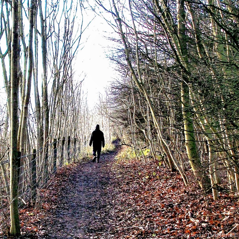
We went for a tramp along the Edge Wood at midday yesterday. It’s three fields up from our back garden and quite a haul to reach it. Once there, a breather is definitely called for, and so it’s a good moment to stop and look at the old Ironbridge Power Station cooling towers.

P1060131

Some find them ugly, but I like them. They are true landmarks – geologically and historically speaking. They stand on the banks of the River Severn, England’s longest river, which rises in the Welsh uplands and descends through the Midlands to the Bristol Channel. The towers stand on a piece of landscape – the Severn Gorge – which was only created 15,000 years ago – a mere nano-second past in Earth History Time.

But the thing that most fascinates me is that the River Severn, presently running south past the towers, once flowed north, so meeting the sea on the coast between North Wales and Chester. This remarkable change of direction is all down to the last Ice Age and the fact that the land was glacier-locked as far south as Shrewsbury, our county town. The Severn’s northern outlet thus became blocked by ice, and so the river backed up, forming a great lake (Lapworth) as the water lay trapped between the ice sheet, and the limestone ridge of Wenlock Edge.

Little by little, as the Ice Age drew to a close, the river wheedled its way through the northerly end of Wenlock Edge and carved a new course, cutting through, and so exposing the Industrial Revolution-making strata of coal, ironstone, fire clay, and limestone. And as I’ve said in other posts, this part of Shropshire lays claim to being ‘the cradle of the Industrial Revolution’, though crucible might be a better metaphor, given the emphasis on iron production.

However, the 18th century pioneering ironmasters of the Severn Gorge were not the first to take advantage of the local geology. Nearly two millennia earlier the Romans were already exploiting these resources. Their military camp of Viroconium (Wroxeter) lay just to the north of the Gorge and, once the locals were suitably subdued, so the camp transformed into a great city, one of the four largest in Britain. There is evidence of glass making and iron working in the area, and local clays would have served for brick and tile production. In fact one of the brick-built basilica walls still rises impressively above the surrounding farmland, a surprising survival when so much of the city fabric was recycled through succeeding centuries.

Back in the Gorge, and many centuries after the end of Roman rule, the mediaeval  monks of Buildwas Abbey and Much Wenlock Priory were also busy making use of local natural resources on an industrial scale. They had mines, decorative tile works, iron-making forges and bloomeries. They also had a thriving export business along the River Severn. There’s a record from around 1200 that states that the Prior of Buildwas was fined because twelve of his barges were blocking the river downstream at Bridgnorth. Probably not your usual vision of what monastic enterprises got up to.

Given so much entrepreneurial and manufacturing business afoot in the Gorge AND a navigable river with access to the great port of Bristol,  it is not surprising that when the monasteries were dissolved in 1540, and their properties distributed to the king’s friends and favourites, that the place should attract a rash of opportunistic London merchants, lawyers and aristocrats, all out to get rich and exploit the former monastic concerns for themselves. Soap  making, cold tar exploitation, coal mining, iron production, steel-making experiments were being conducted by very unlikely people of the well-heeled sort across south-east Shropshire.

Such industrial fervour was further stoked by Queen Elizabeth I (1533-1603) who offered a prize for anyone who could find a way to smelt decent iron using coal instead of charcoal. The loss of the nation’s great trees, needed for naval purposes and the protection of the realm, was causing the monarch much concern. The prize, however, was to remain unclaimed. It would be a good century later before  Abraham Darby arrived in the Gorge and, after remodelling a former monastic iron works in Coalbrookdale, perfected the much sought-after technique.

His discovery helped shape the world we occupy today. See what geology has to answer for.

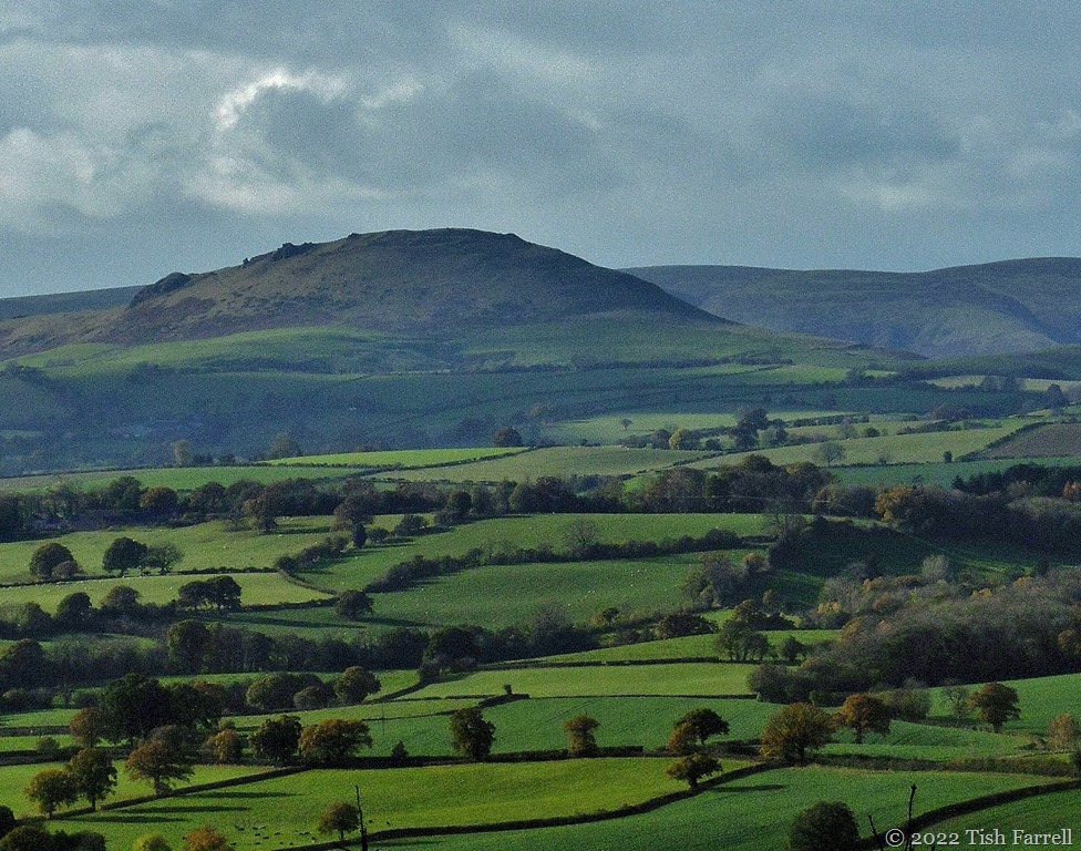
And here’s some more of quite another sort: the Wrekin. We have the best view of it on our homeward path back down into Wenlock.

P1060146

The plain to the left of the hill was the location of the glacial Lake Lapworth. The Roman city was in that vicinity too. The Severn Gorge is off-screen to the right of the Wrekin.

I’ve written about the Wrekin’s mythological and geological origins HERE, but I may not have mentioned there that it has an Iron Age hillfort on the top. This was a stronghold of the Celtic Cornovii  i.e. those who  were duly subdued and citified by the invading Romans. Under Roman rule Viroconium became the Cornovii regional capital, which they continued to occupy until the late 600s – 700 C.E. when the site was abandoned.

We were always told at school that Viroconium’s last days were due to Saxons or Vikings marauding up the River Severn, but there is no sign that the exit from the city was anything but peaceful. I remember working on the excavation of the presumed road-of-retreat long ago as an archaeology student. I have to say that at the time I wasn’t altogether convinced by the site director’s interpretation of the remains that we were uncovering. At least it made me consider that much depends on the way you excavate a site. This site was being stripped across a whole field, rather than being investigated through the judicious placing of exploratory trenches. It seemed to me that certain trowelling techniques, as applied by willing and enthusiastic novices, might be responsible for creating features that aren’t actually there at all. An interesting thought on how the past might be re-created and invented.

And now just to prove how cold it was on our ramble, and not just gloriously, and so unexpectedly sunny: next some ICE, a phenomenon not witnessed in these parts for several seasons. Which brings me back to the start of this yarn, but hopefully not to the start of a new Ice Age as long predicted by certain climatologists. There have been enough tangents along our path already.

P1060148

copyright 2016 Tish Farrell


Jo’s Monday Walk  Please take a turn in this quarter for another fabulous ramble with Jo in the Algarve.

giant gwendol makes the wrekin

100_5822


As hills go, The Wrekin (pronounced REE-kin) in my home county of Shropshire is not very high – just over 400 metres (1300 feet) . But then, as estate agents say, location is all, and this is the only big hill for miles around. It rises over a county of farm fields and the flatness of the Shropshire Plain beyond, and thus is a useful landmark when navigating the county’s ancient network of sunken rural roads. It has also long loomed large in local imagination. As with significant natural features the world over, it gives people something to think by, prompting many a tale and joke.

For instance, we have a saying whose usage extends into neighbouring  counties. To go all round The Wrekin means to ramble on for hours before arriving at the point. Hopefully not exemplified in this post. Because yes, I will get around to Giant Gwendol before too much longer. But first some geology. Please don’t groan. I’ll make it snappy.

Looking at the photograph above, the first thing that strikes you is that the hill looks like an old volcano, and I seem to remember being told that it was in year 3 geography at secondary school. This apparently is not the case, although it is composed of volcanic rock. The vent that spewed it out is no longer around or visible. This is perhaps worrying. One has to put faith in notions of volcanic dormancy and, since the spewing forth of rhyolites, tuffs and agglomerates took place in the Precambrian some 680 million years ago, we can perhaps rest easy in our beds: Shropshire has had long enough to get over its hot phase. 

This is also good because as you can see from the second photo, the place where I live, Much Wenlock, is rather close to The Wrekin. The yellow wheat field in the middle ground is behind my house.

But now for the Gwendol story.

IMG_1285


There once was a Welsh giant called Gwendol. For reasons unknown he had conceived a grudge against the mayor and townsfolk of Shrewsbury, in the neighbouring county of Shropshire. Since the town lay within a nearly closed loop of the River Severn, Gwendol came up with a dastardly plan. He would dam the river and so drown the town and all who lived there.

He set off from Wales with a great spadeful of earth to do the deed, and headed for Shrewsbury. He tramped for mile after mile, but somehow lost his way, ending up instead near the town of Wellington. Weary with the search, and from carrying a heavy load, he sat down to rest.

After a time, an itinerant cobbler came walking by. He had walked from Shrewsbury and was heading for Wellington. Over his shoulder he carried a big sack of used shoes for mending.

Gwendol stopped the man and asked for directions. He even told the cobbler his plan to fill in the River Severn and so drown Shrewsbury and all who lived there.

The cobbler was horrified, and especially appalled at the prospect of losing so much trade.

He thought fast.

“Oh dear me,” he told the giant, “that town is so far away. Many days’ walk.” Then he opened his sack of  old shoes. “See,” he said. “I have worn out all these shoes and boots walking from Shrewsbury.”

At this, the giant groaned. “I am too tired,” he said, “to carry my load of dirt that far. I had better leave it here.” And so he emptied it out there and then and, as a parting shot, before setting off back to Wales, he cleaned the mud from his own boots, and so left behind little Ercall, the small hill that stands nearby.

And so now you have the true story of how The Wrekin was born. In fact, for a not very bright giant, I think Gwendol did a pretty good job, landscaping-wise. Also the damming plan would never have worked. Old Shrewsbury town may sit inside the loop of the River Severn, but it is also on a very steep hill. Just as well, though, that Giant Gwendol trudged back into Wales and was never heard of more in Shropshire.


IMG_1364


copyright 2014 Tish Farrell

SOURCE: This tale appears in Charlotte Burne’s Shropshire Folklore 1883. In other versions the Devil is the hill-builder.

Flickr Comments ‘G’ words