Rooftops And Chimney Pots

IMG_2010sq

We have had masses of rains lately, so not much walking, but yesterday afternoon we were treated to an unscheduled burst of sunshine. We popped into town for some milk, and on the way home up Sheinton Street, this back-garden cherry tree caught my eye. And then the chimney pots with the sun on them, plus the odd visual juxtaposition of Wenlock Priory ruins, and the surviving roof-height elevation of the south transept (just to the left of the tree).

Walking Squares #16  Please join Becky on her November walks.

IMG_2010header

Winter On The Edge

100_7046 sq

The National Trust owns the north-east facing scarp of Wenlock Edge. There’s a good path along the summit which, in gaps through the trees, offers stunning views of north-east Shropshire. It also skirts the old limestone quarries which now provide quarters for, among others, a garden fencing company and an outfit turning trees into pellets for industrial wood burners. The quarry enterprises are by no means scenic, but they have a certain drama. The National Trust trail and map are HERE.

100_7056sq

Looking towards the North Shropshire Plain and the Wrekin

*

100_7051sq2

IMG_1929sq

Edge Renewables

*

IMG_1946 - sq

Walking Squares #8  Join Becky on her daily November walks

And Another Wenlock Walk

IMG_1139sq

This feels like a old path, the way hollowed out between field boundaries, the ground worn threadbare to rock and knotty tree roots. As you leave the town and climb towards Callaughton, you need to watch your step, and take the occasional breather. Which is good too, because it means there are chances to stop at windows in the vegetation and look back on the town.

In the next view, I’m looking roughly north, the Wrekin in the distance, and in the far right you can just spot the windmill atop Windmill Hill. The field directly beneath the Wrekin and woods (bordered by a short row of pink roofs) is Townsend Meadow. Immediately forward of the field is the allotment, but you can’t see it for trees.

IMG_1123sq

*

Now turning towards the east so you can the tower of Holy Trinity Church. It was once part of the Wenlock Priory complex. But the oldest parts of the church are said to date to the days (before the Norman Conquest) when the priory was a convent for both men and women, though they worshipped seperately. It is thus believed to be the site of the original women’s church, but has obviously undergone much rebuilding over the centuries. In fact during reburbishment in 1101, the supposed remains of St. Milburga were found near the altar, she who was the first abbess of Wenlock (675-690). The discovery of the saint’s bones, described in 1190 by Bishop Odo, as ‘beautiful and luminous’, put Much Wenlock on the pilgrim route and led to the town’s rapid growth. Happy days for the Priory coffers.

IMG_1127sq

*

The path brings you out on Callaughtons Ash, a field on the boundary with the historic township of Callaughton. To our ears the word ‘township’ is perhaps misleading. These days the settlement is little more than a hamlet, and it may never have been much bigger in the past, though records show there was  a weeping cross in the vicinity in the 13th century which doubtess attracted the devout. It is anyway one of seven ‘townships’ that surround Much Wenlock and once fell within the town’s ancient parish boundary. Others include Bourton, Farley, Harley, and Wigwig. And I have no idea how the Wigwig name came about.

There’s a fine view of Clee Hill at the top of the path:

IMG_1134sq

Walking Squares #7 Keep walking with Becky.

Coming Home From The Edge

IMG_0067sq

It’s interesting but when you are walking about in Much Wenlock, you are very rarely aware of how steeply the land rises towards Wenlock Edge, or of the fact that the town sits in a distinct hollow with other not-so-steep hills rising to the east and south.

In this photo I am walking down from the Edge, following the path that ends up on Sytche Lane, a short hop from our garden gate. We’re lucky to have so many good walks on our doorstep, and mostly field paths, too.

Walking Squares #5 Today Becky is taking a walk close to home.

IMG_0067cr

Wildegoose Garden’s Sculpture Show

IMG_1512ed

Real-life rabbits are the last thing this gardener wishes to encounter in her garden, but these terracotta ones by artist Sharon Griffin would be more than welcome. They were spotted back in September when our favourite plant place Wildegoose Nursery (set inside a historic walled garden) hosted a sculpture show by our favourite gallery, Twenty Twenty. It was a perfect match all round: art among the late summer perennials on a dreamy afternoon. And blissful to meander the garden paths and come upon some extraordinary creations. Here is a selection of works that caught my eye.

IMG_1516ed

Self in stoneware with sgrafitto by Sharon Griffin

*

IMG_1540ed

Mitosis: a storm fallen field maple by Glen Farrelly

IMG_1557ed

Flaunt 2022 powder coated steel by Anya Beaumont

IMG_1562ed

Starlight Tower in terracotta stoneware by Emma Fenelon

*

IMG_1520

Insight: stone and bronze resin by Sue Jones

*

IMG_1539

Walking Squares #4 

Join Becky on her November walks.

Windfall Quinces At The Allotment

IMG_1993

For one reason or another, but mostly due to some serious rainstorms, I had not been to the allotment for several days. When it wasn’t raining, slithering across the field in the mud did not appeal. And then the wind got up. And then just when I thought I’d go, another downpour began. And so it seems that after our too arid  summer, we’re in for a very wet autumn.

But yesterday came the window of opportunity. The morning was almost sunny. We anyway needed some veggies. So wellies on, off I trudged along Townsend Meadow, which is now a green haze of sprouting wheat. The rain is suiting it. It has also been suiting all the field beans spilled during the summer harvesting. They have been pushing up through the wheat, and I noticed yesterday that the farmer has clearly been over the field with his big herbicide sprayer. I find it astonishing that plant-killing chemicals can be so attuned as to know a broad bean seedling from a wheat stem. Anyway, the application is clearly doing its stuff, and the wheat looks fine.

IMG_1988

*

Up on the plot all is soggy and much blown about, and certainly not at all photogenic. There was lots to gather though – leeks, beetroot, chicory, carrots, and still some tomatoes, lettuce and rocket in the polytunnel. I didn’t stay long. The wind was gusting up into a small gale. You can see what it did to quince crop. The tree this year was laden. It seems a waste not to use the fruit, but apart from quince jelly, which needs loads of sugar, it’s not really a favourite in the Farrell household.

IMG_1893

Townsend Meadow: wheat and field beans (before the spraying)

#WalkingSquares This November join Becky in her daily walks, or whenever you can, the only rule, the header photo must be SQUARE. 

Castle in the Air?

IMG_1975ed

Does this look real to you?

It doesn’t to me, and I was there, a coupld of days ago on All Hallows Eve, taking this photograph. It’s a view I’ve captured before, but somehow these ruins of Ludlow Castle set high above the River Teme, always manage to look like some idealised Victorian watercolour; or a film set; even dream-like. Yet there was nothing dreamy about the conception of this massive fortification. Its construction began in the 11th century with the sole intention of keeping the Welsh princes in their place behind the nearby England-Wales border.

IMG_1983ed

It’s other significance, in my mind at least, is that in the winter of 1501 Prince Arthur Tudor, heir to the English throne and Henry VIII’s older brother, spent his honeymoon here. He had married the Spanish princess, Catherine of Aragon, both of them still in their teens.   You can read more this story here: Honeymoon Destination Anyone?

But in any event, even with the walls intact, and some well tapestried royal chambers somewhere within, it takes a great leap of imagination to consider this an ideal honeymoon venue. Presumably Arthur’s presence  was a political gesture to impress the Welsh neighbours. In any event, it did not end well. It seems that both Arthur and Catherine fell ill with the ‘sweating sickness’, a strange and passing disease of Tudor times. Catherine recovered but by April 1502 Arthur was dead. And the rest, as they say, is history.

My own experience within the castle walls dates back to the late 1960s. It was a summer’s evening and the time of the Ludlow Arts Festival which every year staged a Shakespeare play inside the castle’s massive inner bailey. Open air of course and on very hard wooden seats. My mother had tickets for Shakespeare’s Richard III. It had poured with rain all day, and I (in grumpy teen mode) didn’t want to go. But by early evening the sky cleared and so we set off for Ludlow, armed with cushions and blankets and a flask of coffee.

There was no set to speak of. Only a platform with a throne against the looming backdrop of the bailey walls. Swifts and swallows whisked by overhead, but as it grew dark it was the turn of the bats to swoop and dive around the battlements. And then came Act 5 scene 3 – the night before the battle of Bosworth Field when Richard is visited by the ghosts of all those he has murdered. And out of the shadows, from different spots around the castle walls, echoed the eerie voices. It was thrilling. Unforgettable. And to think I hadn’t wanted to come.

#Lens-Artists: Flights of Fancy  Johnbo has set this week’s challenge. Go see his different approaches for this theme.

On the Road In Much Wenlock ~ ‘A Rip Van Winkle Kind Of A Place’

Much Wenlock Sheinton Street towards Holy Trinity Church

Sheinton Street looking towards Holy Trinity Church

*

It’s a while since I posted any photos of my home town. These shots are all from the archive, but I had a notion to edit them in sepia tones, along with a touch of over-exposure here and there to accompany  the century-old quotation from Shropshire writer Mary Webb. I mean to say, even with all the cars, it still has that  look. There’s definitely a sense of Winkle time-slippage. This may well have something to do with the fact that this small town has been continuously occupied for  more than a thousand years. And before that, there would have been Romans and Romano-British wandering around the place with the likelihood of a villa/bathhouse on the site of the medieval Wenlock Priory. And before that, itinerant Bronze Age smiths may well have passed through, one of whom lost his stash of arrow and axe heads in the River Severn not far from Wenlock. Or maybe it was a donation for a safe crossing.

Many of the facades you see in the photos have been added on the front of much earlier buildings – this during periods of particular market-town prosperity when there were attempts at gentrification. I say ‘attempts’ because by all accounts even in the late nineteenth century there was a smelly open sewer running through the town. Also the place was regularly doused in limestone dust with every blasting at surrounding quarries. And there would have been some evil smog too from lime burning kilns (this to produce lime for building mortar and fertiliser).

Much Wenlock High Street

Looking down on the High Street

*

Much Wenlock The Bullring

The Bull Ring where once  the popular sport of bull baiting took place on fair days and holidays

*

Much Wenlock The Square

The Square (looking past the church towards Wilmore and Sheinton Street)  with the Museum on the left (once the Butter Market and then a cinema) and the 16th century Guidhall opposite. The assizes were held on the upper floor, the lock-up down below. These days the town council holds its meetings there.

*

Much Wenlock Queen Street

Queen Street and Brook House Farm, one of the last surviving town farms, now ‘done up’ into several desirable residences. I remember it with cattle in the barn.

*

Much Wenlock High Street with Reynalds Mansion

The High Street featuring our star timber-framed residence – Reynolds Mansion, a fifteenth century hall with a grand 1682 frontage

*

Much Wenlock High Street towards Gaskell Corner

Top of the High Street. This row of stone clad cottages contains some very ancient inner parts.

*

Much Wenlock High Street and Wilmore Street with Guildhall

Much Wenlock Sheinton Street towards New Road

Looking down Sheinton Street from the Farrell house

*

Much Wenlock lane beside Priory ruins

Downs Lane beside Wenlock Priory

*

Related: Wenlock: “A Rip Van Winkle kind of a place

Cee’s Black & White Photo Challenge: roads

Across The Gulf ~ Mirage Or Mountains?

3

I’m still not sure if the Taygetus mountains of the Mani Peninsula are fact or figment, and I stared at this view for an entire week – at daybreak, at twilight, in sun and in storm. Real or not, these mountains beckoned. And I was entranced. Still am, when I look at the photos. They were taken from Harakopio (Peroulia Beach) in Kalamata, Greece, overlooking the Gulf of Messenia.

I’ve read my Patrick Leigh Fermor (Mani: Travel in the Southern Peloponnese) which sets off most beguilingly, penetrating on foot this all but impenetrable mountain peninsula (that until recent times scarcely had a road into the interior), but then, after some stunning episodes, the account digresses into convoluted regional history that this reader found more uphill-going than the near-vertical terrain.  Still, it’s a book worth tackling for the magical inside-Mani experiences. It truly is.

2

But if the mountains have long kept people out, then it’s a different story for the coastal foothills. Some settlements along the shore, accessible only by sea, have been occupied since Mycenaean times, i.e. the Ancient Greek Bronze Age (c1750-1000 BCE). If you squint, you can see signs of humanity in the first photo.

But that’s enough of the prosaic. These scenes are just for dreaming.

P1020403ed

1

Lens-Artists: the mountains are calling   This week Amy sets the challenge.

Communing With The Ancestors At Dyffryn Ardudwy

60 dyffryn ardudwy effect

Scan an ordnance survey map of Wales, and especially the county of Gwynedd where we were a couple of weeks ago, and you will soon spot a host of prehistoric remains: hut circles, standing stones and chambered tombs. They can be found on the coast, in the immediate hinterland and in the uplands of Snowdonia, thus giving an impression of a very busy ancestral landscape.

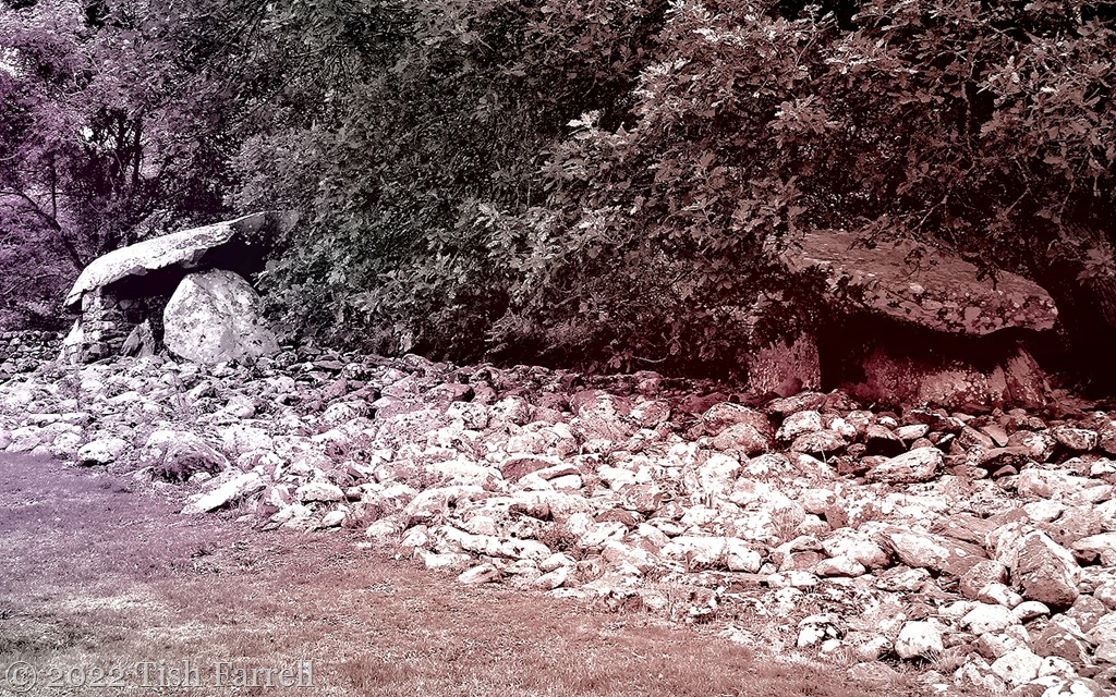
Of course there is no way of knowing if these are the scant remains of many more monuments, lost to collapse, deliberate destruction and/or repurposing by later populations, or if they roughly represent the sum of the stone-built prehistoric past. Another problem is dating them. For example, Neolithic chambered tombs appear to have served the whole community, were constantly re-used and so remained in use over a considerable period of time. On our recent Wales trip we found a good example in the little village of Dyffryn Ardudwy (OS grid ref: SH585235), one of a group of 6 similar monuments between Barmouth and Harlech.

The unusual feature here is there are the two burial chambers in close proximity, the earliest (far right in header photo) dating from around 6,000 years ago and built by Neolithic farmers. This was originally covered by a small oval cairn, but with a forecourt facing east. Shards of Neolithic pottery were found during excavations.

Sometime later, the larger easterly chamber was constructed, and the whole area including the earlier chamber and its surrounding cairn, was covered by a large trapezoidal barrow  some 100 feet (30 metres) long. This construction phase also included a forecourt facing east. These forecourts are thought to have provided the ceremonial setting for funerary rituals. The big scatter of rubble is all that is left of the mound. Over succeeding millennia it has doubtless provided a handy source of building material.

28

9

6

The building of such monuments suggests that Neolithic communities had both plenty of human-power and the spare time to do the building work.  And while the large chamber slabs most likely came from the immediate vicinity, they still had to be shifted and lifted.

From our consumption-heavy perspective is easy to think that stone age life was tough and impoverished. But the coastal region would have been very rich in resources – not only a range of seafood, especially shellfish, but also the wildfowl, fish and game of the salt marsh estuaries to supplement farm produce.

The immediate hillside area was anyway still occupied two plus millennia later by Bronze Age-Iron Age people. In the next field to the burial cairns are the stone foundations of two circular houses together with evidence of field terracing and an enclosure. So life went on there, though probably with settlers of quite different/or at least mixed cultural origins.

But one of the most beguiling features of the Dyffryn ‘house of the dead’ in our era is that it feels embraced. The path to it runs beside the village community centre and then beside the primary school, the setting is cared for, pastoral, almost domestic. It’s reminding me of a chambered tomb of the cromlech variety I once spotted on a lane skirting a Breton farmyard. The tomb had been incorporated into the outbuildings; the past very purposely repurposed and impressively too. Adaptive re-use as conservation persons are wont to say. I like it.

5

Related: Pentre Ifan chambered tomb.