Musings On Time Past ~ What Do We Make Of It?

pentre ifan

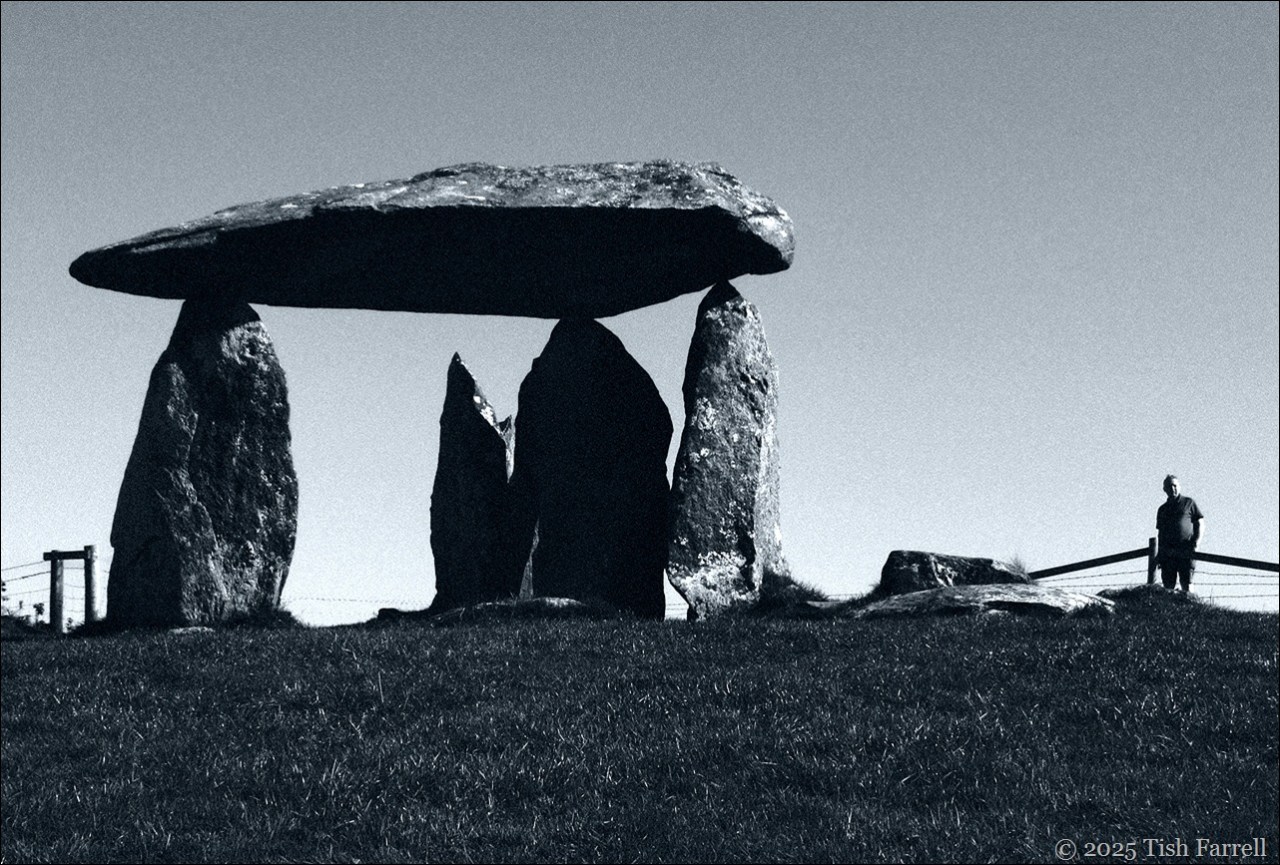
Remains of Pentre Ifan chambered tomb, Newport, Pembrokeshire c. 3,500 BCE

*

We humans have problems with time: too much of it; not enough; the wrong kind for a planned action or pronouncement; then there’s ever that tale of elders who forget what they had for breakfast, but recall in minute detail events of decades past.

We try to pin it down of course, have long done so with all manner of devices. Most likely the late ‘Stone Age’ people who constructed Pentre Ifan above, had contrived the means to keep track of it. For instance, the placement of so-called standing stones, the particular configuration of megalithic circles, the siting of tomb entrances, whence to observe the movement of stars, the angle of the sun, and so know where they stood in relation to the earth’s perceived cycles. A time to plant; to make a journey; to hunt; to trade; mark seasons for rites and festivals.

Mitchells Fold

Mitchell’s Fold Bronze Age stone circle, Shropshire-Powys border

*

We don’t know who these prehistoric (pre-literate) people were. There is no apparent connection between us and them. How do we even begin to grasp what five and half thousand years actually means. Most of us, unless we spring from some dynastic household that records family pedigrees down the centuries, or derive from some close knit community where little has changed for generations, cannot name our four pairs of great grandparents without the help of genealogy.com. We certainly have no true idea of how they lived day to day, unless they kindly left us their diaries; and even then…

As L.P. Hartley says in the opening of his novel The Go-Between: ‘The past is a foreign country; they do things differently there.’ And for most of us, too, our generations of ancestors left no mark, but were ever caught up in ‘big people’s’ histories; the machinations of church and state.

*

There are anyway far bigger pasts than our human one. Here in my home county of Shropshire, in the borderland known as the Welsh Marches we have  some of the planet’s oldest parts. Seven hundred million years old, in fact.

Set against such a monumentally unimaginable timescale, the history of humanity, including that of our primate ancestors, is not even a magnified dot on the horizon.

This is what Peter Toghill has to say about the Marches geology:

The beautiful landscape of the Welsh Marches
is underlain by a rock sequence representing ten of
the twelve recognised periods of geological time…
This remarkable variety, covering 700
million years of Earth history, has resulted from
the interplay of… (1) erosion and
faulting which have produced a very complex
outcrop pattern; (2) southern Britain’s position near
to plate boundaries through most of late
Precambrian and Phanerozoic time; and, most
importantly, (3) the incredible 12,000 km, 500
million year, journey of southern Britain across the
Earth’s surface from the southern hemisphere to
the northern, caused by plate tectonic processes
.

An introduction to 700 million years of earth history in Shropshire and Herefordshire

*

P1030691

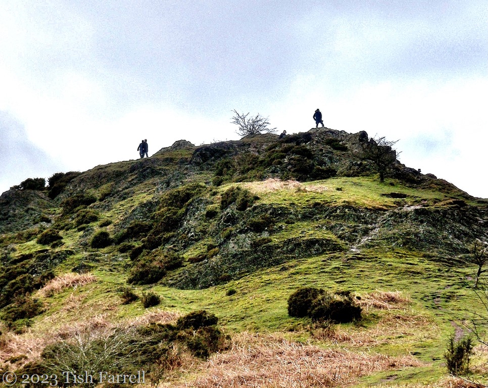
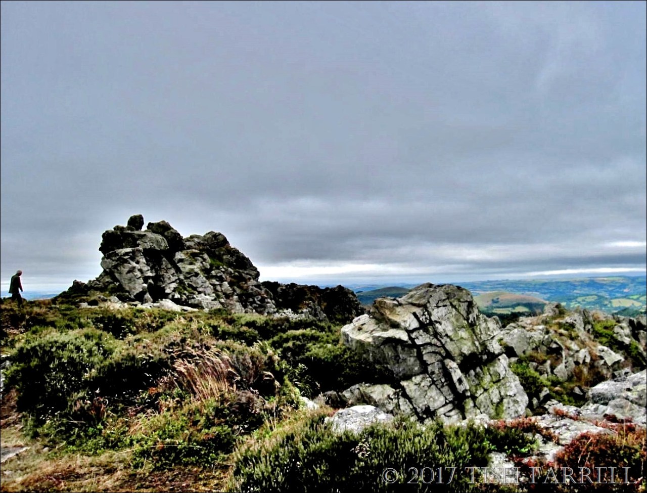
This distant view of the Stiperstones from Mitchell’s Fold stone circle, shows two of the Ice Age tors along the five mile summit, (Manstone the highest point on the left). This hill was probably formed from the laying down of quartzite sand when the whole of Southern England lay in the southern hemisphere, somewhere near the Comoros Islands in the Indian Ocean. That was around 500 million years ago, about the time when it began to move north. The tors themselves were exposed far more recently, by the repeated freezing and melting of glaciers that nudged up against them during the last Ice Age (115,000 to 12,000 years ago).

*

Stiperstones shaped by ice sheets freezing and melting

P1080553cr

Makes me think we humans sometimes think too much of ourselves and what we think we have achieved. Maybe the planet has the edge on us by a few hundred million years. It’s certainly done some momentous shunting and shifting.

Lens-Artists: Ancient

Cinematically Cornish

P1080012cheesewring Bodmin

This week at Lens-Artists Sofia calls for a cinematic approach to our photography.

This is what she says:

“There are a few things that give a photo that cinematic feel: camera angles, bold and high-contrast colours, light, locations, just to name a few. The main objective is to take a shot that is part of a story, there’s mood and a sense of location; our image is but a snapshot of a much wider situation.”

The first four photos here were taken one bleak spring day on the edge of Bodmin Moor near Minions in Cornwall. This, Great Britain’s most south-westerly county is a land of dramatic vistas: of high moors and rugged shore-lines. There are stories everywhere, layered through time like the ‘pillows’ of this granite tor, known locally as the Cheesewring.

The tor has its own stories of course. The first is one of weathering over millions of years, wind and rain driving into its crevices. Then there is the Dark Ages tale, from the post-Roman times when Christian missionaries  were beginning to make their presence felt. The proponents of new faith were not always welcomed, and so the formation of the Cheesewring is explained as the result a quoit-throwing contest between Uther the giant and a saintly missionary named Tue. If Uther won, then the Christian must go. Th giant lost of course.

The Cheesewring name itself has different derivations – either a straining device for making cheese, or else relating to cider brewing wherein the press of apples to a pulp is referred to as cheese.

There also some mystical notions, for it’s said that if you come to the Cheesewring as day dawns you will see the top ring turn three times. Which makes me wonder if that crow might have something to say on the matter.

*

Below the Cheesewring we step back into the remnants of a prehistoric landscape: three Neolithic stone circles called the Hurlers. But as to that figure apparently hovering on the horizon – who knows what time stratum he belongs to.

P1070982ed

P1080022ed

Looking through the Neolithic circle we come to another narrative: one belonging to the 1850s – 1890s when the South Phoenix Mine was churning out train loads of copper, a time when over 3,000 people were employed here – women and children included.

P1070983ed

There is more about these stories at an earlier post: ‘Hurlers and Miners: 6,000 years of heritage on Bodmin Moor’ HERE.

*

Cornwall does have its own cinematic history. Several Cornish based novels by Daphne du Maurier have made it to the big screen, some in duplicate versions – Rebecca, Frenchman’s Creek, Jamaica Inn, My Cousin Rachel. Her deeply disturbing short story,The Birds, is also set in Cornwall, although Hitchcock chose to transpose it to San Francisco. Du Maurier’s works are usually classed as romances, but they also have dark undercurrents, sometimes touching on the paranormal, their settings the wilds of Bodmin Moor, brooding mansions, sheer-drop sea cliffs, rocky coves and crashing surf.

So here are some more Cornish photos, taken one gloomy December, and with a little nod to Daphne du Maurier’s sensibilities.

P1020701ed

*

P1020927 ed

*

P1020611ed

Lens-Artists: Cinematic This week Sofia at Photographias sets the theme.

The Silence Of Stones

100_6999ed

This is Shadwell Quarry on  Windmill Hill, Much Wenlock, part of the Wenlock Edge Silurian reef system.

There’s an air of brooding here, even on a bright winter’s day: of violation survived, albeit roughly; scrub and small silver birch trees recolonising the horizontal shelves. It’s a silence all its own, cupped by sheered off walls and the mysterious deep pool below. Then there is my own silence: awe at the scale of this one-time endeavour now shut down, truncated, closed as if it never mattered: the hard lives of the men who worked here, their injuries and doubtless deaths, unrecalled.

P1000657 Shadwell

Half a century ago, this hillside and the nearby town of Much Wenlock rocked with every quarry blast. Then came the soft fall of lime dust that clung to every surface.

The quarry closed in the 1980s, but in its heyday in the late 19th-early 20th centuries, steam powered goods trains huffed and clanked up the incline from the Ironbridge Gorge to the quarry’s own siding, there to take on stone to use as flux in iron smelting at the Coalbrookdale Works and the furnaces of the Black Country; industries that are also long defunct, or exported to China along with the roar of red-hot hearths, the crucibles’ hiss of pouring iron, shouts of foundrymen.

But then there’s another absent soundscape here, one so ancient it is hard for human minds to grasp. The limestone reef exposed in this quarry began to form over 400 million years ago in a shallow tropical sea somewhere off the Comoros Islands in the Indian Ocean. In waters teeming with corals, sea lilies (crinoids), bony fish, sponges, trilobites and molluscs began the depositing, compacting and solidifying of decomposing animal parts. And while this was happening there was apparently no terrestrial life, but instead there were endless howling gales rampaging across the landmass; brutal winds terrifying in their loudness.

Good that they’ve gone then. Instead we are left with other ungraspable events, for instance, envisaging how vast land masses shunted around the planet, ending up in places many thousands of miles from where they began; the slow, slow scrunch of tectonic plates; the gradual upthrusting and folding of ancient strata; a world we somehow think is in our power!

The stones beneath our feet, the rocky uplands maybe silent, but they have wider, wiser perspectives to impart if we choose to pay attention. I think our ancestors may have understood something of this.

IMG_1947 ed

Wenlock Edge quarry

*

Lens-Artists: Silence  This week Egídio explores the principles of silence in the work of American photographer, Robert Adams. Please see his photo essay and be inspired.

Old As The Hills: That Would Be 570,000,000 years

100_9277ed

I recall being told by my geography teacher (aeons ago) that the Shropshire uplands comprised some of the world’s most venerable rocks i.e from the Precambrian era. The hills in question lie either side the Church Stretton fault, just across the Long Mynd from where we live now in Bishop’s Castle. On the east of the Stretton Valley are Lawley, Caer Caradoc and Ragleth, all formed from volcanic lava and ash around 570 million years ago. The Long Mynd lies to the west and began forming a little later with the build up of mud- and sandstone sediments in shallow seas.

Most astonishing of all, this whole process began when the earth’s crust beneath the land on which I now live was sited south of the Antarctic Circle. I’ll say that again: South Shropshire once lay south of the Antarctic Circle. Which obviously means this part of the British Isles has travelled from one end of the globe to the other.

On that journey, over millions of years, sea levels rose and fell; tectonic plates collided as continents shifted and shunted; uplifted landmasses were compressed, folded, tilted.

Then a succession of Ice Ages knocked the hills into shape. The Long Mynd is probably the most dramatic example – seen here in the the next photos taken in Carding Mill Valley, near Church Stretton. From 2.4 million years ago to 20,000 years ago glaciers shifted around the Mynd. When the ice sheets melted during interglacial periods, streams fed by melt water and rain carved out deep valleys, locally known as ‘batches’.

How mind-bogglingly amazing is this for a piece of landscape sculpting: water power plus the passage of time.

P1030461ed

P1030466resixws

IMG_6743ed

P1030464ed

P1030457

Lens-Artists: Time

Good Heavens: A Real Sand Castle?

12

We did not go inside the castle on our recent visit to Harlech on the Mid-Wales coast. To tell the truth I’m rather offended by the tyranny that these brutish bastions of Edward I  represent. He, the irascible English monarch (1272-1307) built a whole string of overbearing fortifications between 1277 and 1304 (Caernarfon being the very grandest), this in a bid to subjugate the Welsh. Of course, in a nice twist of historical irony, the castles are now major international tourist attractions, bringing welcome income to the Welsh economy. (Take that, Edward Longshanks!)

What interested me was a little photo exploration of the castle’s present setting.

For instance, the header photo is something of a trompe l’oeil. Quite misleading in fact. The castle does not sit among the massive sand dunes that have invaded much of the Welsh coast over past centuries and are still growing. It sits on a 200 foot (61 metres) eminence of ancient Cambrian rock (the Harlech Dome), whose footings were once lapped by the sea, and where ships bringing in supplies would once have docked.

So yes, here we have a fascinating case of falling sea levels, or rather, rising land levels. Parts of  Britain’s landmass have risen, and apparently some are still rising (e.g. Scotland) in response to the post-glacial ice weight reduction (isostatic rebound), as in ten thousand years after the event, while others, e.g. south east England, where there are newer rocks and/or compacting clay strata (as in London), are sinking or eroding each year.

Geology has much to answer for. It is ongoing, never static.  A pity that most of us (and that very much includes Mrs. Farrell) know so little about it, or the forces that have shaped and continue to influence the planet. I seem to remember my geography teacher, aeons ago, telling us that Britain was tilting. And it’s far from being the only place where geology is still  moving upwards or downwards. [e.g. an unrelated phenomenon in the Pacific where satellite data show many atolls and islands are growing in size rather than eroding].

But back to Harlech. There’s a diagrammatic reconstruction of the early 14th century castle’s outer defences and setting above the sea here:

13

16

This photo above gives you a glimpse of the golf course that lies between Harlech  (castle and lower town) and the massive dune system behind the now distant beach.

And looking from the other direction:

14

*

It should be said that the Welsh people did not take English oppression lying down. There were a good few revolts and uprisings, and one in particular in 1400 under Owain Glendwyr, an actual Prince of Wales (as opposed to the  fabricated English ones of recent times). He captured Harlech in 1404 and made it his family home and military HQ for four years. He also held his second parliament there in 1405. However, for all that, Welsh rule was short lived. English forces retook Harlech in 1409 during the reign of Henry V.

*

20

21

Looking from the castle towards North Wales, to Eryri, the mountains of  Snowdonia, and the plain below where once there was sea.

23

19

*

It is intriguing how things change, and how if we fail to grasp in what ways they change and why, we truly risk  losing the reality plot. As we headed to the beach I was amused by this sign on the golf course:

43

Where once there was passage for ships, the biggest risk is now flying golf balls. Who’d’ve thought it.

And finally an old image of the castle around 1890-1900 courtesy of the Library of Congress on Wikipedia:

Harlech Castle c 1890 Library of Congress

*

More about the Morfa Harlech dune system HERE. Yes, it is still growing.

44

Lens-Artists: One Subject Three Ways  Patti wants us to look at our subject from different angles.

On The Ice-Sheet Path ~ Stiperstones Revisited

IMG_0542ed

This time we approach from the west, the Shropshire border with Wales below and behind us.  The path from The Bog climbs up through sheep pasture hedged with gorse. The gold is dazzling. In sun-sheltered hollows, out of the wind, the flower-mass gives off coconutty scents. The grassland too is flushed with gold – a mass of buttercups.

After a steepish climb, the path sets off more evenly along the foot of the Stiperstones ridgeway, the quartzite tors of Cranberry Rocks and Manstone Rock standing proud on the skyline. We are making for the Devil’s Chair (header photo), but it is still invisible at this point along the path.

IMG_0515re

The tors’ rubble spill  (stone runs) makes them look more like man-made spoil heaps than natural phenomena. And of course this was an industrial landscape across nearly two millennia:  from Roman times to the early 20th century. Although back then the activity was mostly hidden from sight in the deep mine shafts and caverns dug for the extraction of valuable lead ore.

The tors, though, are their own work, their response to environmental pressures – the fractured tumble created by the freeze-thaw cycles of the last glaciation when the Welsh ice sheet nudged up against the hillside, but did not cover it. In fact, as we follow the path, we must be walking over terrain where the ice would have lain feet deep, the far edge below the tors ebbing in surface melt-water in summer, resuming the deep-freeze lock-down in winter.

It’s surely not too hard to imagine?

For as we walk here under the sun, the bright gorse and lush new bilberry bushes, bleating of lambs, distant mew of a buzzard, I note that even now in late May, the wind still has a piercingly icy edge.

It reminds me, too, that for some reason most of us have decided, on the basis of nothing in particular, that the planet has somehow done with ice ages; that they must be a thing of the past. Yet the last ice sheets only retreated 10,000 years ago; we are presently in an interglacial, the Holocene.

IMG_0527re

Within interglacial periods there are phases of warming and cooling. E.g. It is generally accepted that around 6,000 years ago that the northern hemisphere was much warmer (Holocene thermal maximum) than it is today (NOAA National Oceanic & Atmospheric Administration US). There is likewise evidence from analysis of pollen and other prehistoric deposits in peat bogs across Europe of  periods of dramatic climatic decline e.g. the Late Bronze Age Britain (from around 3,000 years ago) when it became much wetter and cooler. Yet by the time the Romans had taken over the land, there was another warm phase. And again in the Medieval period, this before the general descent into the Little Ice Age of 14th-19th centuries for which there are also historical accounts. (I mentioned the London Frost Fairs of the Little Ice Age in a recent post on chaotic weather.)

The cycle of ice ages and climatic variation within interglacial phases is apparently dependent on shifts in the inclination of the earth on its axis, plus associated so-called ‘wobbles’, together with variations in the sun’s energy output. In other words, there can be  no doubting that here we have in play planetary cycles that are stratospherically beyond humanity’s capacity to control. Anyway, it’s making me think that hanging on to the woolly jumpers and thermal underwear might not be a bad idea.

And talking of woolly jumpers, as the Devil’s Chair comes into view I find myself the subject of ovine scrutiny…

IMG_0532re

IMG_0533re

*

And now for the Devil’s Chair, long the subject of Shropshire myth and witchery:

IMG_0540ed

*

And the view from this spot, back towards Cordon Hill, the border and Wales. Remember that ice sheet. This was the land that it covered. At the glacial maximum around 22,000 years ago the ice was estimated to be up to half a kilometre deep. Sheffield University has produced some interactive maps.

IMG_0545re

IMG_0546re

The dark tussocks are heather which will bloom in late summer. The bright green bushes are bilberries, locally called win- or wimberries – our native version of blueberries, ready to pick around August time, but presently flowering. The little rosy bells are hard to see, but the bees are finding them:

IMG_0555re

*

As we retrace our steps to The Bog where we’ve left the car, I’m stopped in my tracks by  the sight of a mountain ash tree seedling. There it is, growing so strongly atop a weathered gate post. It makes me smile. It seems like a sign: the earth, the real world, has much to teach us when we choose to pay attention.

IMG_0559ed

Rocks, boulders, Stiperstones

P1080542cr

Shropshire’s mysterious Stiperstones featured in a recent Square Odds post. Here are more shots in monochrome, plus a few facts for geology lovers.

The grey-white rock of the ridge is quartzose sandstone known as the Stiperstones Quartzite Formation, created some 480 million years ago in the Ordovician era.

The tors and the rubble-like surroundings we see today are the work of more recent events in the last Ice Age (c. 115,000 – c. 11,700 years ago).  During this time, the eastern edge of the Welsh ice sheet was nudged up against the Stiperstones, not covering it,  but causing the quartzite to fracture during periods of intense freezing followed by thawing.

The highest point (Manstone Rocks) is 536 metres (1,759 ft) above sea level, making it the county’s second tallest hill after Brown Clee.  The ridge extends some 8 kilometres (5 miles), the summit crowned with a series of six distinctive outcrops.

For geology buffs there is a detailed overview of Shropshire’s 700 million year geological history by Peter Toghill HERE.

This next photo: men on Manstone Rock, the highest point on the Stiperstones…

P1080557cr

P1080558cr

P1050991cr

P1060001cr

Cee’s Black & White Photo Challenge: rocks, boulders, stones

It Seemed Like A Small Treasure

IMG_3991

There it was lying among the chaff and wheat stalks, a small fossil brachiopod, the size of my thumbnail, both shells of the bivalve quite intact, but washed free of its sedimentary matrix, to be found by me as I wandered about in Townsend Meadow after the harvest.  I was out in the field, relishing the new views, seeing the town from fresh angles as I climbed the hill, and much like Monet with his many haystack renditions, as I went, snapping multiple views of the large straw bales. With the morning sun on them they looked like some rustic art installation.

I saw the fossil from the corner of my eye and instantly switched to archaeologist mode, at first hoping it might be a Roman coin. It was a similar size and pewtery dullness to the ones I’d uncovered at nearby Wroxeter Roman City when I was digging there aeons ago. But no. It is a washed up remnant from the Silurian Sea, the 400 million-year shallow ocean, whose bed in more recent eras thrust upwards to form Wenlock Edge.

But that’s not all that is marvellous. Before the upthrusting, back in the oceanic days when this little mollusc was still busy sifting warm currents to find its lunch, the land beneath my feet was lying south of the Equator, somewhere near the Comoros Islands in the Indian Ocean. It takes one’s breath away: Shropshire to the Comoros. Is all too hard to grasp. Too much time, too much planetary expanse for the mind to girdle. I mean how could the world’s parts have done so much monumental shunting about? And we humans with all our technology think ourselves masters of the globe. Silly, silly us.

Anyway, I brought the little fossil home, and it sits on my desk. It feels like a touchstone, an omen, a talisman. What meaning might I take from it? This 400 million-year-old mollusc found by chance among the chaff and sawn-off stalks after the wheat harvest.

copyright 2019 Tish Farrell

IMG_3978


Christmas Walk Through The Mists Of Time

P1100539

Here we are – midday on Christmas Day in Ashes Hollow, Little Stretton, Shropshire, walking across some of the oldest landscape on the planet. Such vast antiquity is perhaps an unexpected distinction within a rural English county whose location, even to the citizens of the United Kingdom, is often a total mystery.

But here it is, one of the valleys, locally known as batches, whose streams wheedle their way down from the flanks of the Long Mynd, a 7-mile ridge of Precambrian rock, formed around 570 to 560 million years ago. It is also well travelled geology, having moved 13,000 miles from its origins in the Antarctic circle where its iron-rich sediments (eroded from volcanic mountains) first accumulated on the sea bed. This was closely followed by some tectonic shunt and shift which squeezed the sediments into a U-shape, so tipping them from the horizontal to the vertical. It’s a feature you can glimpse here and there on exposed rock faces. It means too, that in one sense at least, as you pass, you are walking through time.

Time Square #27

Back To The Stiperstones ~ Or Slow Under The Surface, And What On Earth Were The Luftwaffe Doing Here?

This week at Lost in Translation, Paula’s prompt is ‘SLOW’. So here is another vista from our recent trip to South Shropshire’s Stiperstones (see also the previous post.) And the reason I’ve chosen it is because I cannot think of anything slower than the trans-global  journey of the landmass on which these hills sit. It has been travelling an inch a year for 450 million years, moving up from its source on the southern shores of the Iapetus Sea, 60 degrees south of the equator and roughly where the Indian Ocean is today. I’m not sure if the land beneath our feet is still heading north, or if one day Shropshire will be in the Arctic.

That’s quite a thought.

The other aspect of slow-going to be seen in these photos is the gradual weathering of the folded, upthrust former beach from which this 5-mile ridge is mostly formed. Much of the shaping began with the last Ice Age when the glaciers extended across Shropshire.

A far more recent, and somewhat bizarre reshaping apparently took place during World War 2, when the Luftwaffe, flying over the north end of the Stiperstones, mistook the rocks of the Devil’s Chair outcrop for a town with ammunition dumps, and duly bombed the place. How they came to this conclusion is hard to understand. Even in the heyday of the local lead mining industry, the communities were small and sparse and tucked into hillsides and valleys. There has never been a town in these parts. Perhaps in the dark the strangely glowing quartzite exercised some mystical, mystifying interference in pilot perception. Who knows?

It is anyway another good yarn to add to the tales of witchcraft and devilry that, in the human imagination of ages, enmesh these bleak uplands.

IMG_5519

We certainly saw no signs of bombing, though it might be hard to spot among the heaps of fragmenting quartzite. These particular shots were taken at Cranberry Rocks at the southerly end of the Stiperstones. We did not make it as far as the Devil’s Chair; it was too hard underfoot and too windy. But we do mean to make another visit one day soon, and tackle the hill from the northern end. We just have to remember not to go when mist threatens, or we might come on the Devil himself, brooding nastily on his craggy, Luftwaffe-remodelled throne.


copyright 2017 Tish Farrell