
It is a wild and brooding place, one of the strangest in South Shropshire’s hill country. For one thing the Devil has his chair there, and when the mist comes down, this is where he sits – brimming with pent-up malevolence but unseen by us mortals.
We did not encounter mist on Saturday when we ventured there so we assumed the Devil was out. But there were lowering skies, a near absence of light and the threat of rain. Oh yes, and wind, that somehow caused a discontinuity of function between brain and feet, so making the trek over moorland paths strewn with quartzite cobbles somewhat hazardous.
The Stiperstones ridge extends 5 miles (8 km), and at its highest point on Manstone Rock is 1700 feet (536 metres) above sea level. Standing on the top you can look west across the great expanse of Wales, and on clear days see Snowdon and Cader Idris mountains. Turn east, and you can scan across the Long Mynd to north east Shropshire and far, far beyond.
The ridge has ancient origins and half the world away, some 60 degrees south of the equator. It probably began existence as a quartz sand beach laid down by a shallow sea during the Ordovician, some 495-443 million years ago. Thereafter the landmass moved one inch a year for the next 450 million years to reach its present location 50 degrees north of the equator. A slow, slow journey, then, of 7,500 miles.
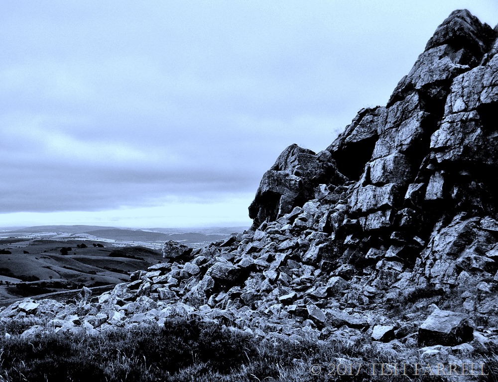
You might think, as you look at succeeding images, that it doesn’t look much like a beach these days. In fact it has suffered much folding, sending the beach skywards, and tilting it at angles of 80 degrees in places. Along its length are a series of quartzite tors described by the eminent Victorian geologist, Murchison, as ‘rugged Cyclopean ruins’ (The Silurian System 1854). Besides the Devil’s Chair and Manstone Rocks there are also Diamond Rock, Cranberry Rock, Nipstone Rock and several other eye-catching outcrops.
The place is also described as ‘relict landscape’, one that is undergoing continuous weathering. What we see today was mostly shaped during the last Ice Age when the quartzite was locked in permafrost. Moisture seeped into the cracks, and as it froze, expanded, causing the rock to fissure and fragment.
The moors below the ridge-top are rich in whinberries and cowberries, and so provided food and grazing for human populations from at least the Bronze Age. These people from prehistory left us their burial monuments – stone cairns along the hill’s spine. Then around 100 CE the Romans arrived, avidly searching of silver, but mostly mining lead, and smelting it in hillside boles to provide material to line their plunge pools, make water pipes, cover roofs, construct their coffins, and for the craftsmen of Wroxeter Roman City to use in the production of pewter.
Down succeeding centuries lead mining expanded dramatically. The flanks of the Stiperstones are littered with adits and the mine shafts that featured so dramatically in Mary Webb’s Gone To Earth. One of the biggest concerns, Snailbeach Mine, started at the foot of the hill in 1783, employed 500 workers at its height. For a century and more, then, the wild countryside was also a filthy industrial zone of delving, massive spoil heaps, steam-pumping engines and hard-worked men and boys.
Yet somehow this phase too has somehow welded itself into the mythic fabric of the landscape, an impression heightened by the strange visual effect of Stiperstones quartzite – that it somehow looks black against the light, when in fact it is grey and speckled with ice white crystals.
And on that note I’ll leave you with the words of Much Wenlock’s Mary Webb, whose writerly landscape this very much was – and in all senses. This quote is from The Golden Arrow:
The whole countryside was acquiring in his eyes something portentous, apocalyptic. For the personality of a man reacting upon the spirit of a place produces something which is neither the man nor the place, but fiercer or more beautiful than either. This third entity, born of the union, becomes a power and a haunting presence – non-human, non-material.


copyright 2017 Tish Farrell
Changing Seasons – Please visit Max for this month’s jaw-dropping vistas from his trekking trip to the Romsdalseggen: not for the faint-hearted.

Haunting is the perfect word. It looks like somewhere to go when you can’t be part of the world any more.
I think you’re absolutely right. It’s an alternative universe right here.
Very striking – bleak but attractive
I think that sums the place up very well, Debbie.
Beautifully stunning!
Thank you, Roda 🙂
So new to me….
Those stones are incredible , love this so much!
Thank you, Anna. You are a lovely audience 🙂
Very interesting and pretty in a different sort of way. thanks
Thanks for reading 🙂
I’m always amazed at how our human atrocities can be eventually absorbed into the landscape. It give me a bit of hope for the future. Mordor, returned to the wilds.
I like that image, and that hope.
So beautiful! Great post!
Thanks for the kind comments, Kendall.
You are welcome, Tish!
Another Ms Farrell, gem. Had me by the oculars! And other photos are lovely.
I love the sense of the truly immense timescale of continental drift. An inch a year fro 450 million years!
And yet overall, this is still peanuts, isn’t it?
And some think it was all done and dusted in a week! Yeah, right!
There is a long and steep road, Stewart Drive, in a nearby suburb where we used to live. It wends its way from one side of the valley to the other and I used to run it when putting in some serious hill training for the longer marathons. There and back equaled 3kms. Five times in a session’ 15 klicks. You felt the burn after that, I tell you!
Anyway, one evening I noticed a round metal sign affixed to a pole against the stone as the road cuts a deep swathe to get from one side of the valley to the other. It is also quartzite. I stopped to read it. Apparently the whole area was once an inland sea! And we are nearly 1800 metres above sea level!
I must do a post on it, one day.
Better still. Found this.
http://www.theheritageportal.co.za/article/three-historic-johannesburg-passes
“Johannesburg at its core is an area town of ridges, giant rocks, outcrops, cuttings, randte, dips, krantzes, gullies, kloofs, sluite and koppies.” Also like the ‘granitic crust’. Fascinating article. And such ‘soles of your feet’ feature descriptors. I love narrative geology, so yes, Ark. You must do a post. The ground beneath our feet is full of stories. And thank you too for the high praise 🙂
I’ll have to go for a drive with the camera. Not too comfortable strolling around with it.
We’ll see …
You need a drone!
*the photos.
Season changes beautifully via your lens, Tina! 🙂
Broodingly beautiful, but I imagine when the sun’s shining, it takes on a completely different atmosphere. 🙂
janet
I did see Max’s stunning landscape shots, Tish, but yours weren’t so bad either! It wasn’t you teetering about on those heights, was it? I hope to see a little bit of the area when I’m down that way next month.
Oh no, not me up there. The path to the bottom was hard enough. And you’re coming this way?
Yes- was going to email you but didn’t see the address on your site? Mine’s on my About page if you’d rather not say. 🙂
Will hope over to same 🙂
What raw rugged country. I’d love to climb those hills, and go scrambling around amongst those rocks.
Alison
And so many more hills around too for scrambling and wandering 🙂
Lovely!
Stunning!
‘The ridge has ancient origins and half the world away, some 60 degrees south of the equator.’ And as I read your post half a world away, I see we have some links in common. In my neighbourhood we have Idris Rd (for Cair Idris), to the west we have Murchison (named for the geologist), and we have greywacke which makes up the majority of the main alps that are the backbone of my island. I can’t find any Romans though. 😀 Great photos.
I love these congruencies, Ann. Shame about the Romans, though some of their activities left a lot to be desired 🙂
I have to laugh at myself…….I have been to Murchison so many times, but it took your post for me to realize the origin of the town’s name.
This was a beautiful gallery and very nicely written too! Unfortunately my post is not so well articulated, but I can always blame it on English not being my native language. 😀
V. many thanks for the kind words, Max. I like the way your write your posts, because you are always being you, and your English is fine!
Love this glimpse into the crevices of the ancient geology, your words and photos are so beautiful!
Thanks so much, Athena.
Great gallery. Certainly translates the landscape well.
Thanks, Mick.
A mythic fabric of landscape indeed. Your words and images sent chills down my arms. Magnificent.
Am taking a bow, thank you.
Wonderful — makes me nostalgic for my days living on Dartmoor. Must visit the Stiperstones ridge. 🙂
Yes, they are similarly bleak and arresting landscapes. Shropshire is rather a hidden gem with all its wild hills, well worth visiting.