
Croft Castle estate, Herefordshire
*


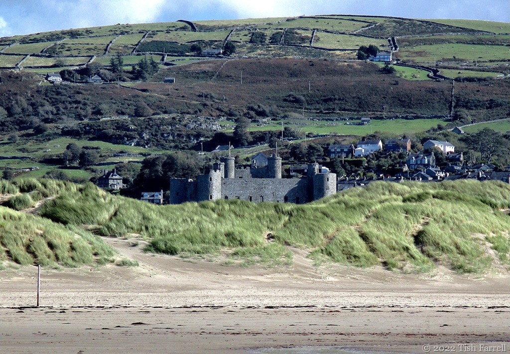

We did not go inside the castle on our recent visit to Harlech on the Mid-Wales coast. To tell the truth I’m rather offended by the tyranny that these brutish bastions of Edward I represent. He, the irascible English monarch (1272-1307) built a whole string of overbearing fortifications between 1277 and 1304 (Caernarfon being the very grandest), this in a bid to subjugate the Welsh. Of course, in a nice twist of historical irony, the castles are now major international tourist attractions, bringing welcome income to the Welsh economy. (Take that, Edward Longshanks!)
What interested me was a little photo exploration of the castle’s present setting.
For instance, the header photo is something of a trompe l’oeil. Quite misleading in fact. The castle does not sit among the massive sand dunes that have invaded much of the Welsh coast over past centuries and are still growing. It sits on a 200 foot (61 metres) eminence of ancient Cambrian rock (the Harlech Dome), whose footings were once lapped by the sea, and where ships bringing in supplies would once have docked.
So yes, here we have a fascinating case of falling sea levels, or rather, rising land levels. Parts of Britain’s landmass have risen, and apparently some are still rising (e.g. Scotland) in response to the post-glacial ice weight reduction (isostatic rebound), as in ten thousand years after the event, while others, e.g. south east England, where there are newer rocks and/or compacting clay strata (as in London), are sinking or eroding each year.
Geology has much to answer for. It is ongoing, never static. A pity that most of us (and that very much includes Mrs. Farrell) know so little about it, or the forces that have shaped and continue to influence the planet. I seem to remember my geography teacher, aeons ago, telling us that Britain was tilting. And it’s far from being the only place where geology is still moving upwards or downwards. [e.g. an unrelated phenomenon in the Pacific where satellite data show many atolls and islands are growing in size rather than eroding].
But back to Harlech. There’s a diagrammatic reconstruction of the early 14th century castle’s outer defences and setting above the sea here:


This photo above gives you a glimpse of the golf course that lies between Harlech (castle and lower town) and the massive dune system behind the now distant beach.
And looking from the other direction:

*
It should be said that the Welsh people did not take English oppression lying down. There were a good few revolts and uprisings, and one in particular in 1400 under Owain Glendwyr, an actual Prince of Wales (as opposed to the fabricated English ones of recent times). He captured Harlech in 1404 and made it his family home and military HQ for four years. He also held his second parliament there in 1405. However, for all that, Welsh rule was short lived. English forces retook Harlech in 1409 during the reign of Henry V.
*


Looking from the castle towards North Wales, to Eryri, the mountains of Snowdonia, and the plain below where once there was sea.


*
It is intriguing how things change, and how if we fail to grasp in what ways they change and why, we truly risk losing the reality plot. As we headed to the beach I was amused by this sign on the golf course:

Where once there was passage for ships, the biggest risk is now flying golf balls. Who’d’ve thought it.
And finally an old image of the castle around 1890-1900 courtesy of the Library of Congress on Wikipedia:

*
More about the Morfa Harlech dune system HERE. Yes, it is still growing.

Lens-Artists: One Subject Three Ways Patti wants us to look at our subject from different angles.


The Mawddach River after the storm. There’s a tension here – a case of estuarian counterflow as the sea tide washes up against the river’s downflow. There’s an odd perception, too, of evolving solidity – of molten metal perhaps – artisan silver with flecks of gold; or of liquid thickening in the making of a sauce. Anyway, I thought it was an interesting effect.

The photo was taken last Wednesday as we arrived in Mid-Wales on the tail of a colossal downpour. We were starting a 4-day stay, and very much fearing a wash-out sojourn. But we needn’t have worried. We did have some fine days.
This is where we were staying – Borthwnog Hall on the banks of the estuary. A return visit after several years, but this time with a balcony view across the salt marsh at low tide. Fascinating places tidal rivers and estuaries. More photos in following posts.


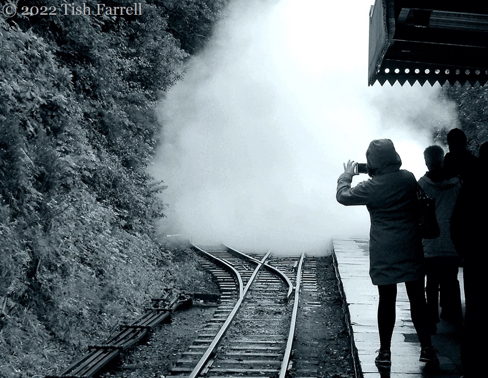

The Talyllyn Railway is a Welsh heritage treasure, once a working line opened in 1865 to haul slate from the quarries of the mid-Wales hinterland to the coast at Tywyn. The narrow gauge line may be only 7 miles long, but you can spend a whole day stopping off at stations en route, exploring Dolgoch Falls, having lunch at the station cafe at Abergynolwyn, or hiking up through the woods to the old Bryn Eglwys quarry. And not only that, you meet lots of happy volunteer drivers and guards along the way, all of them bursting to fill you in with fascinating railway facts.


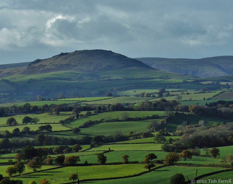

Wenlock Edge behind our house runs for twenty odd miles, a wooded escarpment that bisects the county of Shropshire on a north-east-south-west axis. It’s not always easy to see out for the tree cover, but here and there, a few choice viewpoints give you a glimpse of Shropshire’s other hills, the Long Mynd living up to its name in the distance here. I’m fumbling for the name of the hill in the middle distance (not recognising it from this angle). It could be Caradoc.
*
If we turn right round in the other direction, then we can see Clee Hill:

*
Closer to home, you can take the National Trust footpath out of Much Wenlock and head for the Edge landmark, Major’s Leap, from where, on a winter’s day, you may be treated to an other-worldly view of the Wrekin, subject of many quaint Shropshire tales. (My version here).

*
And coming down the Edge footpath behind our house you have a fine view of Much Wenlock hugged round by hills, Walton Hill and Shirlett Forest:

*
And while I’m showing off our local hills, I can’t leave out the town’s favourite landmark: Windmill Hill with a small turquoise person heading over it:

Lens-Artists: over the hill Donna at Wind Kisses has set this week’s challenge.

Ash trees at St. Brides Castle, Pembrokeshire
*
This week Cee says we can pick our own black and white images. These are some of my favourite shots of Welsh winter scenes.

Llanddwyn Island, Anglesey
*

Farm fence, Aberffraw, Anglesey
*
 Winter dawn, Menai Strait, Anglesey
*

Family gathering, Penmon Point, Anglesey
*
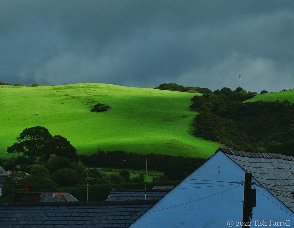

This week at Lens-Artists, Tina shows us many creative ways to interpret her chosen theme ‘opposites’. I thought I’d choose just one photo – a chance weather moment in Wales – one of those hard-to-credit solar beams piercing a storm-heavy sky. I mean to say, how can that field be so luminously green when the town of Harlech below is so deep in shadow, and the clouds above so full of rain? I even desaturated the image a notch or two. Of course there are other opposites here too: townscape-landscape; manmade-natural; urban-rural.
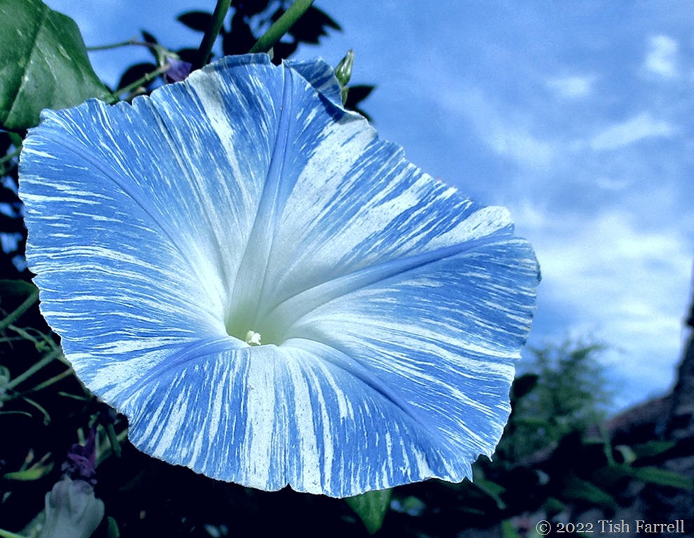

Morning Glory Flying Saucer caught ‘in full flight’ on our downstairs terrace wall yesterday morning.
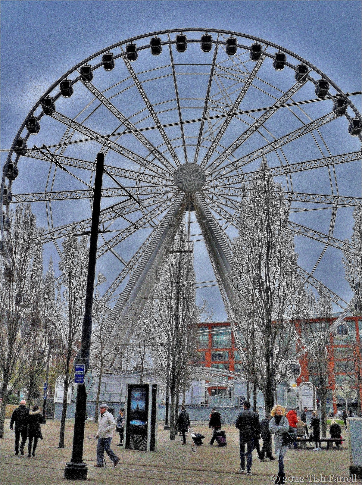

This is the wheel that was, aka the Wheel of Manchester, a version of the London Eye, which was sited in Piccadilly Gardens, Manchester until 2015 when its licence with the City Council expired. This photo was taken in April of that year. It finally came down in the following June. I’m not sure what my camera was doing to produce the washed-out, somewhat retro look, but I rather like it. In fact everything about it says ‘urban’ to me – the sense of detachment/isolation/alienation/coldness; an environment overwrought to the extent of being pointless.
You can tell I’m a country lass.
Though having said that, generations of my maternal ancestors worked in the Manchester cotton trade that created the city and all its wealth: hand loom weavers, yarn winders, blouse finishers, machine weavers, bleachers, fustian cutters, fly and spindle manufacturers, cotton merchants and one mill owner. And then there were the bricklayers who helped build the place. So perhaps, after all, I do have some investment there – at the cellular level.
Here are more odd photos taken on that visit…
ed")
Last walls standing: the facades of the old wholesale fish market, preserved as the perimeter entrances to an apartment block courtyard garden.
*

Not sure what’s going on here – Steam Punk meets Mary Poppins the musical?
*

A tribute to city high-rise window cleaners perhaps?
*

The Bridgewater Hall international concert venue. We were there to see Buena Vista Social Club on their farewell tour.
*
Affleck’s in the Northern Quarter – an indoor market specialising in alternative clothing and music and retro-gaming
*


The Palace Hotel where we were staying (now The Principal Manchester). It was a long climb to find our room in the converted former Refuge Assurance Office built between 1891-1895.
*
Lens-Artists: Urban environments Sofia has set the theme this week. Please pay her a visit.


Townsend Meadow
*

Windy Winter Dunes at Rhosneigr, Anglesey
*

Wenlock hedgerows

*
And one nosy sheep

