Windfall Quinces At The Allotment

IMG_1993

For one reason or another, but mostly due to some serious rainstorms, I had not been to the allotment for several days. When it wasn’t raining, slithering across the field in the mud did not appeal. And then the wind got up. And then just when I thought I’d go, another downpour began. And so it seems that after our too arid  summer, we’re in for a very wet autumn.

But yesterday came the window of opportunity. The morning was almost sunny. We anyway needed some veggies. So wellies on, off I trudged along Townsend Meadow, which is now a green haze of sprouting wheat. The rain is suiting it. It has also been suiting all the field beans spilled during the summer harvesting. They have been pushing up through the wheat, and I noticed yesterday that the farmer has clearly been over the field with his big herbicide sprayer. I find it astonishing that plant-killing chemicals can be so attuned as to know a broad bean seedling from a wheat stem. Anyway, the application is clearly doing its stuff, and the wheat looks fine.

IMG_1988

*

Up on the plot all is soggy and much blown about, and certainly not at all photogenic. There was lots to gather though – leeks, beetroot, chicory, carrots, and still some tomatoes, lettuce and rocket in the polytunnel. I didn’t stay long. The wind was gusting up into a small gale. You can see what it did to quince crop. The tree this year was laden. It seems a waste not to use the fruit, but apart from quince jelly, which needs loads of sugar, it’s not really a favourite in the Farrell household.

IMG_1893

Townsend Meadow: wheat and field beans (before the spraying)

#WalkingSquares This November join Becky in her daily walks, or whenever you can, the only rule, the header photo must be SQUARE. 

Castle in the Air?

IMG_1975ed

Does this look real to you?

It doesn’t to me, and I was there, a coupld of days ago on All Hallows Eve, taking this photograph. It’s a view I’ve captured before, but somehow these ruins of Ludlow Castle set high above the River Teme, always manage to look like some idealised Victorian watercolour; or a film set; even dream-like. Yet there was nothing dreamy about the conception of this massive fortification. Its construction began in the 11th century with the sole intention of keeping the Welsh princes in their place behind the nearby England-Wales border.

IMG_1983ed

It’s other significance, in my mind at least, is that in the winter of 1501 Prince Arthur Tudor, heir to the English throne and Henry VIII’s older brother, spent his honeymoon here. He had married the Spanish princess, Catherine of Aragon, both of them still in their teens.   You can read more this story here: Honeymoon Destination Anyone?

But in any event, even with the walls intact, and some well tapestried royal chambers somewhere within, it takes a great leap of imagination to consider this an ideal honeymoon venue. Presumably Arthur’s presence  was a political gesture to impress the Welsh neighbours. In any event, it did not end well. It seems that both Arthur and Catherine fell ill with the ‘sweating sickness’, a strange and passing disease of Tudor times. Catherine recovered but by April 1502 Arthur was dead. And the rest, as they say, is history.

My own experience within the castle walls dates back to the late 1960s. It was a summer’s evening and the time of the Ludlow Arts Festival which every year staged a Shakespeare play inside the castle’s massive inner bailey. Open air of course and on very hard wooden seats. My mother had tickets for Shakespeare’s Richard III. It had poured with rain all day, and I (in grumpy teen mode) didn’t want to go. But by early evening the sky cleared and so we set off for Ludlow, armed with cushions and blankets and a flask of coffee.

There was no set to speak of. Only a platform with a throne against the looming backdrop of the bailey walls. Swifts and swallows whisked by overhead, but as it grew dark it was the turn of the bats to swoop and dive around the battlements. And then came Act 5 scene 3 – the night before the battle of Bosworth Field when Richard is visited by the ghosts of all those he has murdered. And out of the shadows, from different spots around the castle walls, echoed the eerie voices. It was thrilling. Unforgettable. And to think I hadn’t wanted to come.

#Lens-Artists: Flights of Fancy  Johnbo has set this week’s challenge. Go see his different approaches for this theme.

On the Road In Much Wenlock ~ ‘A Rip Van Winkle Kind Of A Place’

Much Wenlock Sheinton Street towards Holy Trinity Church

Sheinton Street looking towards Holy Trinity Church

*

It’s a while since I posted any photos of my home town. These shots are all from the archive, but I had a notion to edit them in sepia tones, along with a touch of over-exposure here and there to accompany  the century-old quotation from Shropshire writer Mary Webb. I mean to say, even with all the cars, it still has that  look. There’s definitely a sense of Winkle time-slippage. This may well have something to do with the fact that this small town has been continuously occupied for  more than a thousand years. And before that, there would have been Romans and Romano-British wandering around the place with the likelihood of a villa/bathhouse on the site of the medieval Wenlock Priory. And before that, itinerant Bronze Age smiths may well have passed through, one of whom lost his stash of arrow and axe heads in the River Severn not far from Wenlock. Or maybe it was a donation for a safe crossing.

Many of the facades you see in the photos have been added on the front of much earlier buildings – this during periods of particular market-town prosperity when there were attempts at gentrification. I say ‘attempts’ because by all accounts even in the late nineteenth century there was a smelly open sewer running through the town. Also the place was regularly doused in limestone dust with every blasting at surrounding quarries. And there would have been some evil smog too from lime burning kilns (this to produce lime for building mortar and fertiliser).

Much Wenlock High Street

Looking down on the High Street

*

Much Wenlock The Bullring

The Bull Ring where once  the popular sport of bull baiting took place on fair days and holidays

*

Much Wenlock The Square

The Square (looking past the church towards Wilmore and Sheinton Street)  with the Museum on the left (once the Butter Market and then a cinema) and the 16th century Guidhall opposite. The assizes were held on the upper floor, the lock-up down below. These days the town council holds its meetings there.

*

Much Wenlock Queen Street

Queen Street and Brook House Farm, one of the last surviving town farms, now ‘done up’ into several desirable residences. I remember it with cattle in the barn.

*

Much Wenlock High Street with Reynalds Mansion

The High Street featuring our star timber-framed residence – Reynolds Mansion, a fifteenth century hall with a grand 1682 frontage

*

Much Wenlock High Street towards Gaskell Corner

Top of the High Street. This row of stone clad cottages contains some very ancient inner parts.

*

Much Wenlock High Street and Wilmore Street with Guildhall

Much Wenlock Sheinton Street towards New Road

Looking down Sheinton Street from the Farrell house

*

Much Wenlock lane beside Priory ruins

Downs Lane beside Wenlock Priory

*

Related: Wenlock: “A Rip Van Winkle kind of a place

Cee’s Black & White Photo Challenge: roads

Across The Gulf ~ Mirage Or Mountains?

3

I’m still not sure if the Taygetus mountains of the Mani Peninsula are fact or figment, and I stared at this view for an entire week – at daybreak, at twilight, in sun and in storm. Real or not, these mountains beckoned. And I was entranced. Still am, when I look at the photos. They were taken from Harakopio (Peroulia Beach) in Kalamata, Greece, overlooking the Gulf of Messenia.

I’ve read my Patrick Leigh Fermor (Mani: Travel in the Southern Peloponnese) which sets off most beguilingly, penetrating on foot this all but impenetrable mountain peninsula (that until recent times scarcely had a road into the interior), but then, after some stunning episodes, the account digresses into convoluted regional history that this reader found more uphill-going than the near-vertical terrain.  Still, it’s a book worth tackling for the magical inside-Mani experiences. It truly is.

2

But if the mountains have long kept people out, then it’s a different story for the coastal foothills. Some settlements along the shore, accessible only by sea, have been occupied since Mycenaean times, i.e. the Ancient Greek Bronze Age (c1750-1000 BCE). If you squint, you can see signs of humanity in the first photo.

But that’s enough of the prosaic. These scenes are just for dreaming.

P1020403ed

1

Lens-Artists: the mountains are calling   This week Amy sets the challenge.

Communing With The Ancestors At Dyffryn Ardudwy

60 dyffryn ardudwy effect

Scan an ordnance survey map of Wales, and especially the county of Gwynedd where we were a couple of weeks ago, and you will soon spot a host of prehistoric remains: hut circles, standing stones and chambered tombs. They can be found on the coast, in the immediate hinterland and in the uplands of Snowdonia, thus giving an impression of a very busy ancestral landscape.

Of course there is no way of knowing if these are the scant remains of many more monuments, lost to collapse, deliberate destruction and/or repurposing by later populations, or if they roughly represent the sum of the stone-built prehistoric past. Another problem is dating them. For example, Neolithic chambered tombs appear to have served the whole community, were constantly re-used and so remained in use over a considerable period of time. On our recent Wales trip we found a good example in the little village of Dyffryn Ardudwy (OS grid ref: SH585235), one of a group of 6 similar monuments between Barmouth and Harlech.

The unusual feature here is there are the two burial chambers in close proximity, the earliest (far right in header photo) dating from around 6,000 years ago and built by Neolithic farmers. This was originally covered by a small oval cairn, but with a forecourt facing east. Shards of Neolithic pottery were found during excavations.

Sometime later, the larger easterly chamber was constructed, and the whole area including the earlier chamber and its surrounding cairn, was covered by a large trapezoidal barrow  some 100 feet (30 metres) long. This construction phase also included a forecourt facing east. These forecourts are thought to have provided the ceremonial setting for funerary rituals. The big scatter of rubble is all that is left of the mound. Over succeeding millennia it has doubtless provided a handy source of building material.

28

9

6

The building of such monuments suggests that Neolithic communities had both plenty of human-power and the spare time to do the building work.  And while the large chamber slabs most likely came from the immediate vicinity, they still had to be shifted and lifted.

From our consumption-heavy perspective is easy to think that stone age life was tough and impoverished. But the coastal region would have been very rich in resources – not only a range of seafood, especially shellfish, but also the wildfowl, fish and game of the salt marsh estuaries to supplement farm produce.

The immediate hillside area was anyway still occupied two plus millennia later by Bronze Age-Iron Age people. In the next field to the burial cairns are the stone foundations of two circular houses together with evidence of field terracing and an enclosure. So life went on there, though probably with settlers of quite different/or at least mixed cultural origins.

But one of the most beguiling features of the Dyffryn ‘house of the dead’ in our era is that it feels embraced. The path to it runs beside the village community centre and then beside the primary school, the setting is cared for, pastoral, almost domestic. It’s reminding me of a chambered tomb of the cromlech variety I once spotted on a lane skirting a Breton farmyard. The tomb had been incorporated into the outbuildings; the past very purposely repurposed and impressively too. Adaptive re-use as conservation persons are wont to say. I like it.

5

Related: Pentre Ifan chambered tomb.

Good Heavens: A Real Sand Castle?

12

We did not go inside the castle on our recent visit to Harlech on the Mid-Wales coast. To tell the truth I’m rather offended by the tyranny that these brutish bastions of Edward I  represent. He, the irascible English monarch (1272-1307) built a whole string of overbearing fortifications between 1277 and 1304 (Caernarfon being the very grandest), this in a bid to subjugate the Welsh. Of course, in a nice twist of historical irony, the castles are now major international tourist attractions, bringing welcome income to the Welsh economy. (Take that, Edward Longshanks!)

What interested me was a little photo exploration of the castle’s present setting.

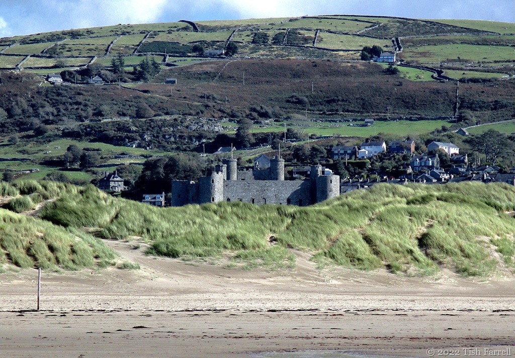
For instance, the header photo is something of a trompe l’oeil. Quite misleading in fact. The castle does not sit among the massive sand dunes that have invaded much of the Welsh coast over past centuries and are still growing. It sits on a 200 foot (61 metres) eminence of ancient Cambrian rock (the Harlech Dome), whose footings were once lapped by the sea, and where ships bringing in supplies would once have docked.

So yes, here we have a fascinating case of falling sea levels, or rather, rising land levels. Parts of  Britain’s landmass have risen, and apparently some are still rising (e.g. Scotland) in response to the post-glacial ice weight reduction (isostatic rebound), as in ten thousand years after the event, while others, e.g. south east England, where there are newer rocks and/or compacting clay strata (as in London), are sinking or eroding each year.

Geology has much to answer for. It is ongoing, never static.  A pity that most of us (and that very much includes Mrs. Farrell) know so little about it, or the forces that have shaped and continue to influence the planet. I seem to remember my geography teacher, aeons ago, telling us that Britain was tilting. And it’s far from being the only place where geology is still  moving upwards or downwards. [e.g. an unrelated phenomenon in the Pacific where satellite data show many atolls and islands are growing in size rather than eroding].

But back to Harlech. There’s a diagrammatic reconstruction of the early 14th century castle’s outer defences and setting above the sea here:

13

16

This photo above gives you a glimpse of the golf course that lies between Harlech  (castle and lower town) and the massive dune system behind the now distant beach.

And looking from the other direction:

14

*

It should be said that the Welsh people did not take English oppression lying down. There were a good few revolts and uprisings, and one in particular in 1400 under Owain Glendwyr, an actual Prince of Wales (as opposed to the  fabricated English ones of recent times). He captured Harlech in 1404 and made it his family home and military HQ for four years. He also held his second parliament there in 1405. However, for all that, Welsh rule was short lived. English forces retook Harlech in 1409 during the reign of Henry V.

*

20

21

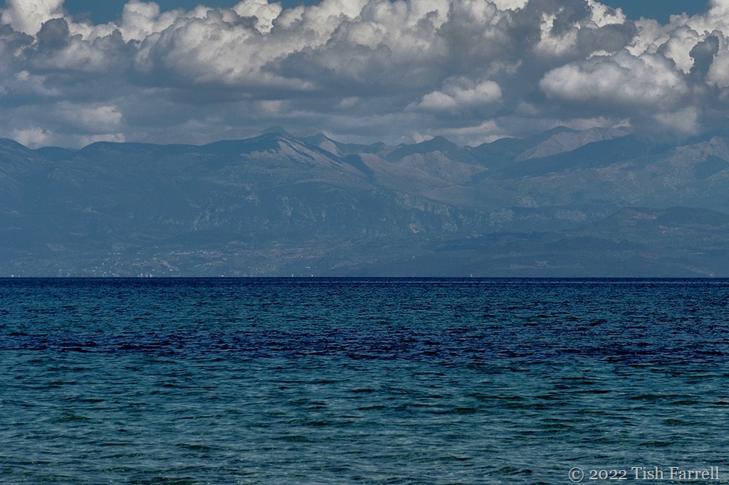
Looking from the castle towards North Wales, to Eryri, the mountains of  Snowdonia, and the plain below where once there was sea.

23

19

*

It is intriguing how things change, and how if we fail to grasp in what ways they change and why, we truly risk  losing the reality plot. As we headed to the beach I was amused by this sign on the golf course:

43

Where once there was passage for ships, the biggest risk is now flying golf balls. Who’d’ve thought it.

And finally an old image of the castle around 1890-1900 courtesy of the Library of Congress on Wikipedia:

Harlech Castle c 1890 Library of Congress

*

More about the Morfa Harlech dune system HERE. Yes, it is still growing.

44

Lens-Artists: One Subject Three Ways  Patti wants us to look at our subject from different angles.

Full Steam Ahead!

101_0162bw

The Talyllyn Railway is a Welsh heritage treasure, once a working line opened in 1865 to haul slate from the quarries of the mid-Wales hinterland to the coast at Tywyn. The narrow gauge line may be only 7 miles long, but you can spend a whole day stopping off at stations en route, exploring Dolgoch Falls, having lunch at the station cafe at Abergynolwyn, or hiking up through the woods to the old Bryn Eglwys quarry.  And not only that, you meet lots of happy volunteer drivers and guards along the way, all of them bursting to fill you in with fascinating railway facts.

101_0157bw

101_0206bw

101_0128ed

Cee’s Black & White Photo Challenge: trains or tracks

Monochrome Favourites

P1040719ed

Ash trees at St. Brides Castle, Pembrokeshire

*

This week Cee says we can pick our own black and white images. These are some of my favourite shots of Welsh winter scenes.

P1060365c

Llanddwyn Island, Anglesey

*

IMG_3308ed

Farm fence, Aberffraw, Anglesey

*

P1060515edWinter dawn, Menai Strait, Anglesey

*

P1060598ed

Family gathering, Penmon Point, Anglesey

*

Cee’s Black & White Photo Challenge: favourites

Urban Fantasies In Downtown Manchester

100_5318ed

This is the wheel that was, aka the Wheel of Manchester, a version of the London Eye, which was sited in Piccadilly Gardens, Manchester until  2015 when its licence with the City Council expired. This photo was taken in April of that year. It finally came down in the following June. I’m not sure what my camera was doing to produce the washed-out, somewhat retro look, but I rather like it. In fact everything about it says ‘urban’ to me – the sense of detachment/isolation/alienation/coldness; an environment overwrought to the extent of being pointless.

You can tell I’m a country lass.

Though having said that, generations of my maternal ancestors worked in the Manchester cotton trade that created the city and all its wealth: hand loom weavers, yarn winders, blouse finishers, machine weavers, bleachers, fustian cutters, fly and spindle manufacturers, cotton merchants and one mill owner. And then there were the bricklayers who helped build the place. So perhaps, after all, I do have some investment there – at the cellular level.

Here are more odd photos taken on that visit…

100_5302 (2)ed

Last walls standing: the facades of the old wholesale fish market, preserved as the perimeter entrances to an apartment block courtyard garden.

*

100_5280ed

Not sure what’s going on here – Steam Punk meets Mary Poppins the musical?

*

100_5259ed

A tribute to city high-rise window cleaners perhaps?

*

100_5192ed

The Bridgewater Hall international concert venue. We were there to see Buena Vista Social Club on their farewell tour.

*100_5311ed

Affleck’s in the Northern Quarter – an indoor market specialising in alternative clothing and music and retro-gaming

*

100_5225

100_5231ed

The Palace Hotel where we were staying (now The Principal Manchester). It was a long climb to find our room in the converted former Refuge Assurance Office built between 1891-1895.

*

Lens-Artists: Urban environments  Sofia has set the theme this week. Please pay her a visit.