

This week at Lens-Artists, John’s theme is ‘History through the lens’. In my last post I was rummaging through our ‘old Africa album’, pondering on a long ago visit to Zimbabwe. And since half my mind is still lingering there, I thought I’d revisit Great Zimbabwe – those tantalising Shona ruins, whose 350-year history we’ll never fully fathom.
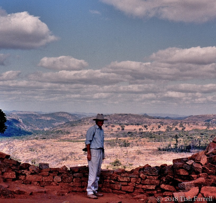
Now as I look through my photos, I see they too are becoming relics, documenting a July afternoon far away and long ago. The winter light was mesmerizing, the air thick and drowsy. Insects thrummed in the grass; all bathed in an amber glow. I recall pressing my palms to the stone wall of the Great Enclosure, absorbing the sun’s warmth, wishing for a portal back in time; to know the true story of this place.
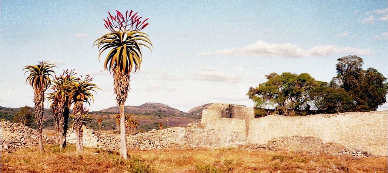
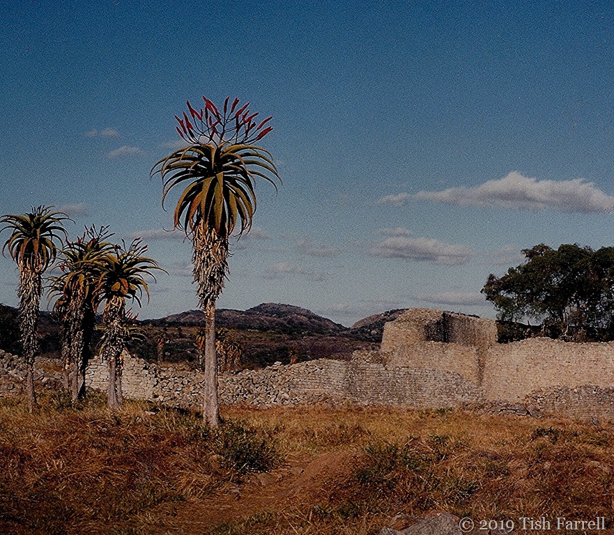
Of course archaeological excavations have yielded some general context. The valley’s stone-built ruins extend over some 1800 acres, an area bigger than medieval London. The earliest date from c1100 CE with successive phases over the following three hundred years. There is also evidence of large houses built of daga or daub, and of an extensive system of water harvesting in so-called dhaka pits.
And as for the people who lived here, the reckoned population of 10,000 souls – the discovered remains suggest they were cattle herders, farmers, gold miners, merchants, iron and coppersmiths, potters, soapstone carvers, soldiers and courtiers, all living under the rule of some powerful organising authority.

Looking down the Great Enclosure (centre)
*

Inside the Great Enclosure with its conical tower of unknown purposes
*

Looking out from the Great Enclosure. No mortar was used in the wall construction. No sign either that this gateway was ever in any way defensive.
*
Among the finds were many luxury goods that indicated a long-standing trade with the Swahili city states of the East African coast (see map below). They included Arabian coins, glass beads, Chinese celadon ware, Persian ceramics, all doubtless exchanged for the city’s gold and copper. And yet their discovery only adds to the puzzle. Why did this seeming thriving city fall into decline from the mid-1400s?

*
Shona oral accounts say the city ran out of salt, and this prompted a shift to new territory. Salt would have been essential for both people and their herds. Other theories suggest an outbreak of disease, a prolonged drought, or the effects of deforestation. There’s no way of knowing. No burial remains have been discovered that might shed light on this.

In amongst the giant aloes, the tumbled remains of an African city that once extended over 1800 acres. It is not known why it declined after 1450 CE
*
But we do know that this was not the end of Shona rule. From the late fifteenth century it seems their centres of operations shifted north, leading to the rise of the Mutapa Empire. Soon afterwards, too, the name ‘Zimbabwe’ enters the historical record. The word itself derives from the Shona phrase meaning houses of stone, and from the early 16th century, it appears in various renditions in the written accounts of Portuguese conquistadores. They were busy scouring the East African hinterland in search of the mines that were yielding the gold they had seen in the Swahili city states along the Indian Ocean coast.
In 1531, Vicente Pegado, Captain of the Portuguese Garrison at Sofala has this to say:
Among the gold mines of the inland plains between the Limpopo and Zambezi rivers there is a fortress built of stones of marvelous size, and there appears to be no mortar joining them … This edifice is almost surrounded by hills, upon which are others resembling it in the fashioning of stone and the absence of mortar, and one of them is a tower more than 12 fathoms [22 m] high. The natives of the country call these edifices Symbaoe, which according to their language signifies court.
In an earlier 1505 letter to the King of Portugal, one Diogo de Alcacova describes a city “called Zimbany…which is big and where the king always lives.” He says the houses are “of stone and clay and very large and on one level” and that there are many very large towns and villages within the kingdom.
Another Portuguese account describes the King of Mutapa’s great retinue which included the governor of the client kingdoms, the commander-general of the army, the court steward, the magician, the apothecary, and the head musician “who had many under him and who was a great lord”. It tells also of the vast territories over which the king ruled, the revenues and subject kingdoms of the king’s several queens.
These references to many large towns and villages and extensive territories ruled over, can be further backed up by archaeological remains. Great Zimbabwe might be the largest surviving ruin, but over a hundred similar sites of varying sizes have been discovered on the High Plateau between the Zambezi and Limpopo rivers. The Empire of Mutapa did once exist. It was only in 1888 that it finally fell to the Portuguese.
Nor was it the only city state. There is another impressive ruin at Khami, near Bulawayo to the west of Great Zimbabwe. It came to prominence at the time of Great Zimbabwe’s decline, and for two centuries the ruling dynasty there oversaw a thriving trading centre, importing luxury goods that included 15th and 17th century Spanish porcelain, Rhineland stoneware and Chinese Ming porcelain.
*
The later European occupiers of African lands would ever assert that local people could not be the builders of these cities. Phoenicians, Arabs, Ancient Egyptians and even the Queen of Sheba were the claimed originators. For a brief account of some of controversies attached to the interpretation of Great Zimbabwe, there’s a fascinating BBC Witness History clip with Zimbabwean historian, Dr. Ken Mufuka.
But in the here and now, looking back on that afternoon at Great Zimbabwe, it seems more dream than reality. But then, courtesy of the Olympus-trip, we do have historical proof we were actually there.


*
P.S. If you want a brilliant, if brief, virtual visit to Great Zimbabwe, go to the Metropolitan Museum of Art page here. The film, posted last year, is only seven minutes long and shows Zimbabwean stone masons at work, repairing and conserving the dry stone walls. It gives an inkling of the extraordinary endeavours of their ancestors.
*
Copyright 2026 Tish Farrell
Lens-Artists: History through the lens Please see John’s post for some fascinating slices of American history.


")


![kenyas-nubians-officer-mw19-910[1]](https://tishfarrell.com/wp-content/uploads/2014/07/kenyas-nubians-officer-mw19-9101.jpg "kenyas-nubians-officer-mw19-910[1]")
![Sudan_Meroe_Pyramids_30sep2005_2[1]](https://tishfarrell.com/wp-content/uploads/2014/07/sudan_meroe_pyramids_30sep2005_21.jpg "Sudan_Meroe_Pyramids_30sep2005_2[1]")
![kenyas-nubians-family-formal-mw19-910[1]](https://tishfarrell.com/wp-content/uploads/2014/07/kenyas-nubians-family-formal-mw19-9101.jpg "kenyas-nubians-family-formal-mw19-910[1]")


![A-Nubian-woman[1]](https://tishfarrell.com/wp-content/uploads/2014/07/a-nubian-woman1.jpg "A-Nubian-woman[1]")


