Borderlands ~ Distance In Time And Space

P1030690a

We’re in border country here – between the Shropshire Hills and Wales  and I’m standing inside a Bronze Age stone circle, Mitchell’s Fold, looking in a northerly direction. And if the circle is a little raggedy  after three millennia, then its location is surely still impressive.

*

Here is the southerly view towards Corndon Hill on whose flanks are the remains of several prehistoric burial cairns. To the right are the hazy Welsh uplands.

a

*

This westerly view towards Wales shows more of the Bronze Age circle. Several of the stones have been laid flat or damaged, and this apparently happened long ago. Perhaps when the land through the circle was being worked. You can see here the rig and furrow outlines of medieval fields. I think the climate must have been milder back then or they grew very tough crops.

100_9480

*

Now looking east, the furthermost ridge is one of Shropshire’s most mysterious and curiously named hillscapes: the Stiperstones with its lunar Manstone and Devil’s Chair outcrops. This ridge is formed from quartzite laid down some 480 million years ago.

P1030691

All these places loom darkly in local legends and folklore. I’ve told the story before of Mitchell, the wicked witch for whom Mitchell’s Fold is named. You can read about her grim deeds and sticky end in an earlier post: Witch Catching in the Shropshire Wilds which also comes with snow-scene photos courtesy of he who no longer uses his camera.

Cee’s Black & White Photo Challenge: In the distance

Cornwall’s Smallest Stone Circle ~ Thursday’s Special

P1020776 - Copy cr

When it comes to photographing prehistoric stone circles, you need the right kind of light, preferably a dramatic dawn or sunset or a good frost. And this clearly wasn’t any of these, but the best I could do on dull, dank December morning. The whole thing was definitely improved by the arrival of the sweet little girl in her tangerine wellies.

Anyway, here it is – Cornwall’s smallest prehistoric stone circle. It is just over thirty feet across (10-11 metres) and is at least 4,000 years old. It sits most domestically behind farm cottages and among a few sheep in the small village of Duloe. There are eight stones, some estimated to weigh around 12 tons, and they were probably chosen because of their high quartz content, which gives them an otherworldly bloom even in this poor light. In any event, they had to be manhandled from the nearest source, at least one mile away.

The  first historical reference to them was in 1329 CE, when they are mentioned in a record relating to the farm called Stonetown (still existing with that name), on whose land they stand.

In 1801 they were discovered again, although at that time the stones were all lying flat and there was a hedge growing through the middle, with a field on one side and an orchard on the other.

Many stone circles in Britain have recumbent stones, (e.g.  see my post on Arbor Low in Derbyshire) and it is usually not known at what stage the stones were laid flat, or in what circumstances. Certainly there is archaeological evidence of prehistoric people themselves ritually ‘closing’ a monument or burial site when it is no longer needed. In more recent times superstitious dread, and/or Christian repugnance at old ‘pagan’ ways prompted people to bury standing stones or lay them down. All of which is to say, everything to do with stone circles is pretty much shrouded in mystery and conjecture.

At Duloe though, there was an interesting and tangible discovery. In 1861, during efforts to restore the circle and raise the stones, a workman put his pick through a Bronze Age burial urn containing human bones. It had been placed at the foot of the largest stone which was also broken during the restoration work, and is still lying on the ground in two pieces. The urn and its contents have since been lost.

But it is this find that provides 2,000 BCE date for the site. However, the circle itself may well pre-date this. As has been shown with recent work at Stonehenge, the world’s most famous prehistoric circle, the stones there were erected in the late Neolithic (c.4,500 BCE) and not in the Bronze Age as originally conjectured, although there are many Bronze Age burials in the vicinity. It also appears that before the Stonehenge stones, there were earlier wooden pillars on the site and these belonged to the Mesolithic period circa 8,500-7,000 BCE when people were still hunter gatherers.

In other words, throughout human existence, a site that has once held, or is perceived to have held ritual significance will often be re-used by succeeding inhabitants across many centuries, and by people of quite different ethnicity and religious viewpoints. So we find Roman temples in earlier Iron Age hillforts, or medieval churches built atop Neolithic chambered tombs.

We cannot divine what these stone circles truly meant to the people who constructed them. But we can surmise that the monumental effort involved implies life and death importance. There are political implications too, both in the conception of the work and in its realisation. Even the building of a small circle like Duloe would have required considerable organisation of people-power. But if these circles have no stories to tell us, they do at least reflect an era when humanity had a very different relationship with the natural and cosmic world than we do today, and that alone might give us some pause for thought.

P1020774

Thursday’s Special Paula’s August ‘pick a word’ prompts include fortified, chic, submerged, embodiment, prehistoric. I think I might claim submerged here too, since the meaning and means of construction of this site are well and truly buried.

copyright 2018 Tish Farrell

Derbyshire’s Arbor Low ~ They Call It The Stonehenge Of The North

IMG_3357

Unlike Stonehenge a visit to Arbor Low does not include accompanying hosts of fellow enthusiasts, tacky gifts and bad coffee, nor the parting with large sums of money to go in (adult ticket £16.50). In consequence there are absolutely no facilities, no opening or closing times, and thus no need to pre-book to avoid the rush.

There is, however, an honesty box by the farm gate, and a requested fee of £1 per person. This is fine by me. The monument, though scheduled, is on private land. The farmer has to put up with the repeated nuisance of standing stones devotees, although on the September afternoon of our visit, takings suggested that scarcely a couple of dozen others had preceded us that day, and as we set off from the car there were only three people ahead of us on the track.

The only problem with Arbor Low is that once you’ve trekked through the farmyard and across the field to visit Derbyshire’s most important Neolithic henge (one’s head inevitably full of Stonehenge images, and lots of anticipation) it all looks decidedly flat when you get there, and so quite lacking in the upstanding drama of its more famous southern analogue. And while Arbor Low surely has considerable edge when it comes to setting (a thousand feet up on a limestone crest of the White Peak)  one wonders why the comparison has been implied at all. Isn’t Arbor Low its own special place?

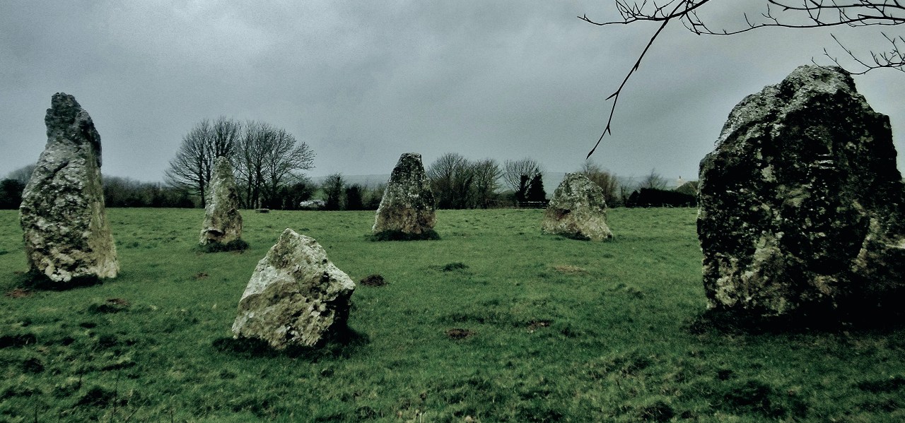
I suppose, then, that mentioning the two sites in the same breath is really more about emphasising their prehistoric importance than suggesting any correspondence in physical scale or appearance. Arbor Low is anyway a much smaller circle. But it does have its own unique features, apart from the recumbent stones that is. These include a very impressive encircling ditch and an outer rampart with the added extra of a later Bronze Age round barrow built across its southerly bank. You can see it on the right of the next photograph.

IMG_3358

So now that I’ve raised the vision of Stonehenge with its great sarsen lintels, I want you to forget it, and think about digging. The time is some four and half thousand years ago. I am the foreman, and I am handing you an antler pick, and maybe a cattle bone shoulder-blade to use as a shovel. We have marked out a circle some 70 metres across, and now you have to start digging 3 metres down into the limestone bedrock, while shovelling up your spoil to create the outer bank.

After many, many, many man-, woman-, and child-hours you can step back and regard the massive earthwork thus created. The freshly dug limestone of the rampart will doubtless have an unearthly white-grey glow. It will be visible from miles around, despite a more wooded landscape than today. At sunrise and sunset it will look spectacular against the skyline, the bank much taller and with a sharper profile that the present remains. In other words, it cannot be mistaken for anything other than a highly prestigious, and momentous man-made structure – the visual shock equivalent of coming upon a designer high-rise in the middle of a wilderness. Or maybe Starship Enterprise.

IMG_3354

After all the digging you are left with a central oval platform around 50 metres across. Perhaps the limestone slabs are already located there, set up on end, and bedded, after much hefting and shunting, in the rocky ground. They could have been worked during the making of the ditch, or sourced from somewhere nearby. In any event, they would have involved considerable effort given your limited toolkit of stone, wood and bone.

From outside the earthwork – and because of the height of the outer bank, you cannot see either the stone circle, or to observe anything that is going on within. Stepping through the entrance to view the newly built monument is thus perhaps a deliberately contrived catch-your-breath moment: the scene before you covert, unnerving, awe-inspiring, drama-filled. If some ceremony is in progress – a narrative declaimed or sung, the outer bank will amplify the sounds in mysterious ways – echoing, resonant, other-worldly; it may be a place of loud whispers.

There will perhaps be no grass cover, just an exposed limestone arena. Around the oval platform you will see some forty standing stones.

IMG_3347

In the centre there is also some kind of sanctuary, a rectangular configuration of more standing stones. The barrow on the southern bank is not yet there. It will be another thousand years before this spot is used as a burial site – perhaps by strangers, perhaps by the distant descendants of  you henge builders. These newcomers have also built another barrow, Gib Hill, just across the field from Arbor Low. Here they raised their own tomb atop the long barrow built by your forebears, a monument that possibly long preceded the stone circle. And so although you can no longer remember the rites and customs of these ancestors, you do know that, like the great mediaeval cathedrals of Europe with their roots in Roman and Saxon times, this place was considered ‘sacred space’ for a millennium and more…

*

And so back to reality and the flattened circle we see today. No one knows when the stones were laid low or why. There are other so-called recumbent stone circles in Britain. Sometimes some of the stones have also been buried. Superstitious dread could have much to do with it: an attempt to neutralise the stones’ power perhaps. There is also archaeological evidence in other contexts that suggests that the prehistoric occupants themselves have ritually ‘closed’ particular sites, perhaps prior to moving to a new centre of operations. There are other more practical reasons too: later farmers came along and simply re-used or moved the stones because they were ‘in the way’.

I also seem to remember from my student field-trip days to Avebury stone circle in Wiltshire that one of the stones had been buried in mediaeval times to cover up a murder. When the stone was being restored to its upright position, beneath it was found the grisly remains of a surgeon-barber, identifiable by the tools of his trade that were still with him. More fanciful interpretations of this find could of course suggest the presumed continuing practice in pagan sacrificial offerings, i.e. the kind of activity that we modern folk so very much like to associate with all ancient stones.

IMG_3353

I suppose one of the most surprising things I discovered about Arbor Low is that there has been no archaeological exploration of this site since early Victorian times when the local antiquarian Thomas Bateman of Lomerdale Hall, and serial excavator of prehistoric barrows, tackled the place. It was he who discovered a human burial in the stone circle barrow and, during his Gib Hill excavation, uncovered a stone cist (a slab built tomb) in which the cremated human remains were placed along with an urn and offerings of meat and flint tools. And this, it seems, is all that is known.

IMG_3364

So many mysteries then, and no likely answers. Instead I’ll leave you with the words of Thomas Bateman and his description of Arbor Low from his Vestiges of the Antiquities of Derbyshire 1848:

…the solitude of the place and the boundless view of uncultivated country are such as to carry the observer back through a multitude of centuries, and make him believe that he sees the same view and the same state of things as existed in the days of the architects of this once holy fane.


copyright 2016 Tish Farrell

Witch-catching in the Shropshire wilds

Naturally, suffering as I do from Out-of-Africa-itis (some of you may just have noticed this)  any mention of ‘wild’ instantly conjures the sweeping Mara grasslands and herds of wildebeeste.  Or scenes of Zambia’s South Luangwa as featured in the last post (here). But then I thought it was time I took more joy in the place where I actually live  and, indeed, grew up – the wonderfully rural county of Shropshire. And for those of you who do not know England, Shropshire is in the Midlands, along the border with Wales. Also as I have mentioned in other posts, this segment of Great Britain was once (400 million years ago) to be found somewhere off East Africa. Shropshire’s rocks are thus among the world’s oldest, and its hills a magnet for geologists from all over the planet.

My home county, then, is largely farming country – dairy, sheep, and arable – the population living in scattered small settlements and market towns, many dating back to Roman times and the early Middle Ages. But there are also many wild places, especially up in the hill country overlooking Wales. One such place is Mitchell’s Fold, a Bronze Age stone circle.

Scan-130804-0041

This bleakly sited  monument comes with a strange legend attached – the tale of a wicked witch and a fairy cow. And so one December day Nosy Writer and the Team Leader set off to explore. Winter seemed a good time to go searching for the spirits of the past. The photographs, by the way, are all Graham’s. Nosy Writer said she could not possibly take her gloves off in such frigid conditions.

The site itself is near the Welsh Border on Stapeley Hill, south west Shropshire. The stone circle was created between three and four thousand years ago, and originally comprised thirty stones of local dolerite. Today, only fifteen are visible. Some were perhaps re-purposed by subsequent generations; others buried. Often such circles were regarded with superstitious dread, particularly during the Middle Ages.

Scan-130804-0012

In the prehistoric past, though, the place was not so isolated as it appears today. In the vicinity are two other stone circles, although one of these, known as Whetstones was blown up in the 1860s. The other, Hoarstones, was said by locals to be a fairy ring, where on moonlit nights, six ‘fairesses’ would dance. There are also numerous cairns and a long barrow, and, not too far away,  the Bronze Age stone axe factory of Cwm Mawr whose finely carved mace heads were traded far and wide across England and Wales. Of the reasons for this and the other circles, all is shrouded in mystery. All that may be said is that once these upland places were of great importance to the people who laboured to make them.

Scan-130804-0039

But what about the witch-catching story, I hear you ask. Well that I can tell you. It goes like this.

Once, when there was a terrible famine in the district, the fairies took pity on the starving peasants and sent them a snow-white cow. The cow was kept in a circle of stones on Stapeley Hill, and, as with all such gifts, there were strict conditions as to usage. Every person was allowed to milk the cow by turns, but only so long as  the cow was never milked dry, and each person took no more than one pail full.

Everyone followed these instructions, and all went well until the wicked old witch who lived nearby grew envious of the peoples’ good fortune. Why had they not called on her to solve their problems? Her name was Mitchell, and out of sheer spite, she thought up an evil plan.

And so one night, when all honest folks were asleep in their cottages, she approached the cow and began to milk it. The only thing was, the bottom of her bucket was full of holes. She milked and milked until the cow was dry, thus breaking the fairy charm. At once the cow sank into the ground, never to be seen again. But Mitchell did not escape either. She had challenged the forces of good too far and found herself trapped inside the stones. And when the people came next day and saw their fairy cow gone,  and they saw the false pail and pool of wasted milk, they knew exactly what the witch had done. So just to  make sure she never escaped, they walled up old Mitchell inside the stone circle, where she was said to have finally starved to death.

Scan-130804-0008.jpg

And just in case you are wondering, no, this is not Mitchell’s ghost in the photo, but me, wrapped up in many post-Africa layers. And beyond me, the Welsh hills.

Finally, here are more scenes of Wild Shropshire – in particular, the hills known as the Stiperstones, which featured often in the novels of Shropshire writer, Mary Webb. The last photograph is of the  peak known as the Devil’s Chair. It also features many local legends, but they will have to wait for another post.

Scan-130804-0006

Scan-130804-0018

Scan-130804-0026