This Morning’s Walk With Some Rural Geometry

IMG_6696sq

*

Barn roofs, gates, styles, fence- field- crop- and power-lines, pylons and pole shadows. Oh yes, and some bull rushes…

IMG_6693ed

A brilliant sun-frosty morning and, so we’re told, the last of the super-cold days. But just the morning for a hike up to the dew ponds above the town.

I love this green lane, perhaps the remains of an ancient thoroughfare between settlements, this before the creation of the modern road system, or maybe even part of the old drovers’ routes out of Wales, shepherds and cattlemen driving their flocks and herds to markets in the English Midlands.

Bishop’s Castle was anyway an important market centre at least as far back as the thirteenth century, when the Bishops of Hereford ruled it from their castle at the top of town. Charters were granted for weekly markets and seasonal fairs to be held outside the castle walls.

On market days this now quiet track might well have been bustling with carts, farmers’ wives with their produce: ducks, geese, hens, eggs, butter, cheeses; farm boys on foot, driving pigs, goats, cattle and sheep to sell. Other traders too might have come this way: basket, hat and chair makers, dealers in songs, fortune tellers, herbalists, and street musicians.

IMG_6697sq

The Long Mynd

*

At the top of the hill are some dew ponds. These are man-made pools, created in upland areas without natural water sources, to provide for grazing stock. Water then collects in them, either rain or field run-off. Some may date from the Neolithic period, that is 6-7,000 thousand years ago. Others may date from the Middle Ages or more recently in the 18th/19th centuries when there was still a high demand for wool. Much skill was required to make them. They started out as a saucer-shaped excavation, about a metre (3 feet) deep, and anywhere between 3-15 metres in diameter. This was then lined with straw, followed by an impermeable layer of puddled clay.

IMG_6725sq

*

One of the dew ponds no longer in use for stock watering is in its own enclosed domain and filled with bull rushes.

IMG_6716sq

*

There are many fine views all round from this point on the footpath; also another dew pond, not presently in use:

IMG_6707sq

IMG_6709sq

*

And in the field with the operational dew pond, lots of ewes waiting to have their lambs:

IMG_6724sq

*

At this point we retrace our steps, although we could (if all of us were willing) follow the path for several more miles, taking a wide loop back into town. Instead, we head straight down the hill, watching the ribbon of fog flowing along the far valley from Clun towards Craven Arms. We’ve recently learned that this mist phenomenon, rather common in these parts, is also called brume.

IMG_6729sq

*

Finally at the foot of the hill by the Wintles, another favourite old barn:

IMG_6734sq

*

And by now it was lunchtime so we called in at Tahira’s Chai Shop  on the High Street for some delicious beef and vegetable samosas (also geometrical) plus lots of good chatting, topped off with (triangular) slices of Rose’s light-as-a-feather, and mouth-wateringly warm cardamom cake. None of which stayed on our plates long enough to think about taking photos. Sorry.

#GeometricJanuary Day 16

Oh, What A Perfect Day…

IMG_6231ed

Yesterday felt as if all our missed summer days had been rolled into one. It was warm, the light golden, the sky a flawless blue in every quarter. In the afternoon I took myself off for a walk – up Laburnum Alley and into Welsh Street, and thence up a green lane out of the Castle and onto the uplands.

IMG_6233ed

IMG_6220

IMG_6191

*

There’s little to hear but the bleating of sheep, the thrum of a combine harvester just over the hill and rook call. The town lies quietly below.

As I climb, I stop to scan the changing vistas. From the highest point there is a near 360 degree ring of hills surrounding Bishop’s Castle, the most obvious for its length being the Long Mynd. Whenever I see the Mynd I always give a mental wave to sister Jo, who lives on the other side. I sometimes thinks it’s odd to have this very big and ancient hill between us; some of the oldest rock in the world in fact.

IMG_6195

Looking east-ish towards the Long Mynd

*

And towards the opposing quarter…

IMG_6221

*

I need a Castle local to teach me the hills, particularly those to the north and west and into Wales. I know the names – Corndon, Lan Fawr, Roundton, Todleth …and I’m guessing they are in the next photo moving from right to left (?) and that the big wood below is Saddler’s Big Wood.

IMG_6228

*

For now, some other scenic spots…

IMG_6223ed

IMG_6196ed

copyright 2024 Tish Farrell

Teeming Green Above Ludlow’s River Teme

IMG_4959ed

The Green Cafe below Ludlow Castle

*

Ludlow is one of Shropshire’s loveliest old market towns, the earliest surviving remains (including parts of the castle) dating from the early Norman period in the 11th century. It’s also one of our favourite places, about 20 miles from Bishops Castle, but we had not visited for ages. And so a couple of weeks ago, when spring was teasing us with the notion that sunny days had returned, we thought it was about time for an outing. A significant lure included thoughts of lunch at The Green Cafe.

This award-winning little restaurant sits on the riverbank, between Dinham Weir and Dinham Bridge. Ever popular, it has an outdoor terrace, and an inside (compact) dining room. But wherever you choose to sit, you are guaranteed a warm welcome, including with added blankets if it’s cold outside and there are no seats free inside.

IMG_4951

*

The menu is always inventive, dishes coming in large or small versions, and with emphasis on fresh, locally produced ingredients. The cakes and deserts are fabulous, although this time we had no room for them. We’d filled up on smoked salmon with pickles, labneh and mustard yoghurt, plus a dish of roasted tiny new potatoes with aioli sauce. All very delicious. After that, there was nothing left to do, but to wander over Dinham Bridge, look at the views, see spring happening and watch the river flow by.

IMG_4968ed

Going with the flow

*

IMG_4962ed

#SquaresRenew   Every day in May Becky is hosting a square format header photo. The themes are move forward, reconstruct, renew, burgeoning.

Breakthrough

6

Day two of Becky’s month of squares. The themes are burgeoning, move forward, reconstruct, renew to interpret how we will. The only rule: the header photo must be SQUARE

*

Sometimes to move forward you need a flash of inspiration: the kind of serious ah-ha moment that brings clarity, or a shift of focus. Not always a comfortable process, mind you, but if it sparks momentum, then that alone can be salutary. Or as Tom Petty put it “if you don’t run, you rust.”

*

This photo was taken one Christmas afternoon on the lane to Penmon Point on the island of Ynys Mon (Anglesey). The view is of the North Wales mainland across the Menai Straits. These extraordinary light shows over the water are a local feature, and so I tell myself that it’s not surprising that the island was the Druids’ last stronghold in the face of the Roman invasion, or that early Christian hermits settled here. (See Island of Old Ghosts.

ed

Early morning above Beaumaris

*

#squares-renew

Seeing Things In A New Light

4

Hurrah for May and Becky B’s month of squares. The themes are burgeoning, move forward, reconstruct, renew to interpret how we will. The only rule: the header photo must be SQUARE.

*

This photo is a view of very familiar terrain as seen from the upstairs windows of our cottage in Much Wenlock. It was a piece of landscape we looked at every day for sixteen years. What wasn’t familiar was this glorious copper light and that cloud come visiting from a Baroque masterwork.

It was early spring, the sun already up at 5 a.m. a time I rarely saw. And now here was the field, usually so plain in the flatness of main-day light, quite transformed. It felt like a parallel universe. So, I thought, this is what Townsend Meadow gets up to when we’re not looking, showing itself off in this magically theatrical glow. What have we been missing?

I never saw anything like it there again, although there were many other light and cloud shows over the years, usually at sunset. But it made me think. Sometimes it pays to break a habit. And if that unexpected view changed the way I saw the meadow, what other bigger shifts may be possible?

#SquaresRenew   burgeoning, move forward, reconstruct, renew

Welcome To My World ~ A Late-Day Walk Above Bishop’s Castle

IMG_4567a

On Sunday I did a lot of complaining about the cold and lack of sunshine. Perhaps the weather gods took pity. At five o’ clock the clouds lifted and the sun came out, and although it was still chilly, we thought a walk was called for. There was a path I had my eye on back in the winter when it was too muddy underfoot to attempt it. But after a couple of downpour-free days and lots of drying wind, I thought it should be passable.

First, though, a spot of orientation by way of some archive photos. Above is Bishop’s Castle High Street as viewed from the Town Hall window. Our street runs parallel to it, behind the ancient timber-framed house in the right hand foreground (the Porch House).

Next is an autumnal view of said street, named Union Street after the Clun Union Workhouse that once occupied the site next door to us, now a care home with a community hospital behind.

IMG_3995

Our walk took us uphill, and left between cottages into Laburnum Alley, a shadowy path that runs between old stone walls and gardens. I imagine much of the stonework along this ginnel came from the demolished castle.

IMG_4077

The path exits onto Welsh Street near the top of the town. There’s a handy kiosk here selling eggs and garden plants and sundry items that need a good home. I noted the tray of chunky broad bean seedlings, and pots of strawberry plants. There was also a notice advertising baby rabbits for sale.

IMG_5031

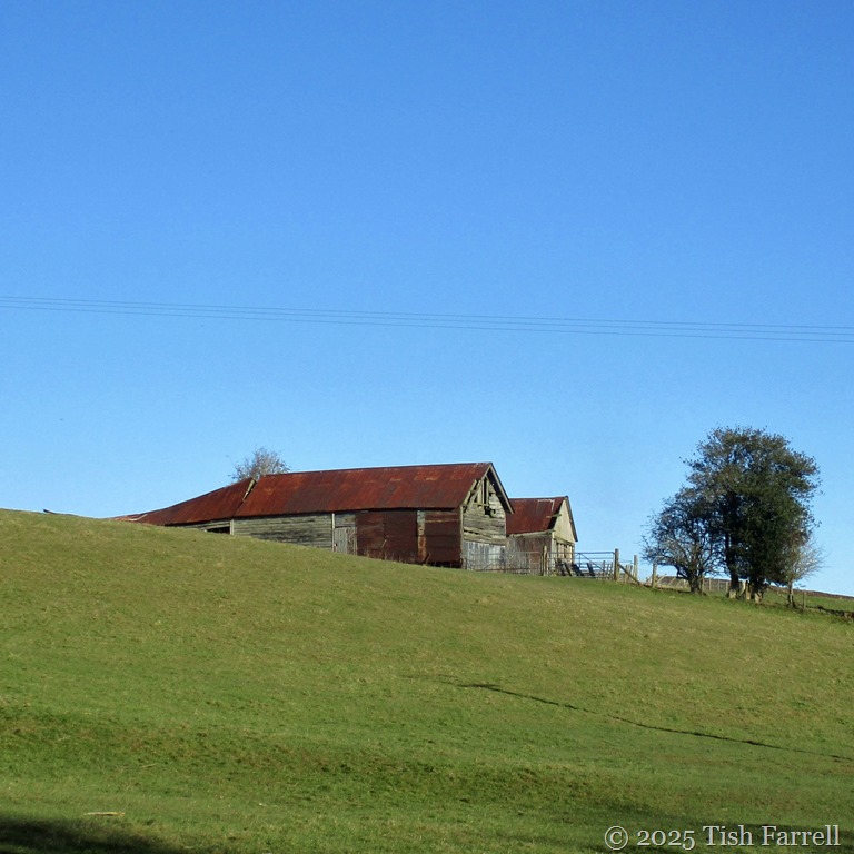
Just beyond the kiosk are a couple of striking looking  barns – a case of scenic dilapidation…

IMG_5033

And across the road is The Wintles, an upmarket community of eco-homes, built in the days before eco-homes were quite invented:

IMG_4154

*

We’re on the edge of town now, and this is the green lane path that had caught my eye. It borders The Wintles’ communal ground of allotment and vineyard.

IMG_5045a

The verges were bright with stitchwort, wild garlic flowers, cuckoo pint, violets, cranesbill, unfurling ferns and cow parsley just opening, Jack by the Hedge aka Garlic Mustard. The lane was sheltered, but even so, I wished I’d put a hat on. It was easy, then, to promise Graham that this was not a major expedition; simply a brief foray to see where the path led.

IMG_5090

IMG_5042

IMG_5044

*

It led us to a gate and wobbly stile into a sheep field. We struggled over. Ahead the pasture rose steeply, and I could tell G’s enthusiasm was waning. Just as far as the horizon, I said, in winning tones.

IMG_5082a

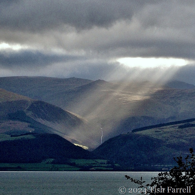
But once we were in the field, we found ourselves looking at marvellous hill country. On our right stretched the Long Mynd, its westerly flanks bathed in sunshine…

IMG_5052a

The sight of the hills all around had us striding on and up, now and then stopping to look back on the town. You can see the parish church of St. John the Baptist, dating from the late 1200s, in the second photo. It stands at the foot of the town.

IMG_5054a

IMG_5055a

*

We were watched of course…

IMG_5078a

IMG_5056

*

At the top of the sheep pasture there was another stile and beyond it an increasingly uncommon sight – a ploughed field (no-till farming becoming the norm these days).

But beyond the plough, what a fabulous scene, the hills of the Shropshire-Wales borderland. A hint of The Lost Continent somehow miraculously manifested on our almost doorstep? It was too exciting. And anyway it was at this point we lost sight of where the path actually went. The way marker arrow suggested straight ahead, but tramping on wind-dried plough is v. bad for the ankles.

IMG_5068a

IMG_5069a

IMG_5072a

A retreat was declared. But we’ll be back to discover more.

*

IMG_5087

IMG_5106

Heading for home down Union Street.

*

IMG_5073header

Jo’s Monday Walk Go here for some stunning Portuguese walking.

Moving Water, the Wales Edition

IMG_1740ed

*

Whenever  you visit Wales, you can always be sure of plentiful H2O. Whether it’s tumbling down mountains, as here at the foot of Cader Idris…

100_6495ed

IMG_1725ed

*

Or filling rivers as in the Mawddach Estuary near Dolgellau…

p1040713bw

57

IMG_1645ed

*

… and the River Glaslyn at Porthmadog  (Wales’ tallest mountain, Snowden, in the background…

100_4726

*

Or on its sea shores…

IMG_0620

at Harlech, North Wales,

*

Broadhaven

P1040499

…Newport and Fishguard, Pembrokeshire:

IMG_4614ed

DSCF1110ed

*

or on the island of Anglesey

Henllys

IMG_0789ed

100_7163

P1060448

P1060382ed

*

Or simply dropping from the sky…

storm

IMG_9280

*

You can tell we love visiting Wales, can’t you?  Though usually best to take good rainwear.

IMG_1740ed2

Lens-Artists: water in motion   This week Sofia inspires us with some wonderful compositions. Go see!

Ancestral spaces

P1080417cr

Offerton Moor viewed from Callow Farm, Highlow, Derbyshire

*

I’ve been posting views of South Shropshire lately, the green and wooded hill country of my home county. It is a terrain that, on the whole, seems more amiable than rugged, although in bad winter weather the tops of Stiperstones and Long Mynd  will ever prove challenging.

But today, on another hoar-frosted day in Bishops Castle, I’m thinking of the Derbyshire Peak District where my maternal Fox family ancestors farmed over many generations. What a tough life they must have led, running sheep on the high moors, struggling to raise essential oat crops in more sheltered enclaves, raising a few cattle to provide milk to make cheese and butter: the cheese a staple with ale and oatcakes, the butter to sell at market.

The header photo is the view from the former farmyard of Callow Farm, last occupied by 3x great grandfather George Brayley Fox in 1892.

Most of the High Peak farmers (even if they were yeomen owning some land and property) were also tenants of large estate owners – the Dukes of Rutland and Devonshire as well as lesser lords of manors. The farms provided food and shelter, but Derbyshire farmers were opportunists too. For centuries they mixed farming with other trades, butchery, hat making, grindstone making for milling and the Sheffield cutlery trade, weaving, haulage, and most dangerously of all, but potentially lucrative, lead mining; this last usually carried out in winter months when there was little farm work.

These next views are of Stanage Edge. This gritstone escarpment lies across the valley from Callow Farm. This is where millstones were once cut and hauled to nearby Sheffield. I know there were farmer Foxes who went in for this arduous trade, but none, as far as I know, in my immediate family tree.

P1000999ed

*

P1080864ed

*

This next photo is of Scraper Low Farm also known as Scraper Low Hall. It stands above Hathersage, and for a short time was the home of my 2x great aunt, Sophia Lister nee Fox who married Mr. Lister the silversmith while still attached to hill farmer, John Brocklehurst who himself had bigamously married a young next-door widow. You can read the story at the link.

When we first came upon Scraper Low, I was astonished that the Listers would choose to move to such a lonely place after living in a Sheffield city centre flat, to say nothing of taking on a farm in their sixties. But then when I walked up the long approach lane, I realised that whenever Sophia walked this way from her extraordinary castellated porch house, she would have been able to scan across the Derwent Valley and spot Callow Farm where she was born in 1814, the place where her brothers George and William still lived.

But then was she engaging in family feeling, or cocking a snook at the relatives now that she could pretend she’d finally made something of herself?

P1080976ed

*

This is the view from Scraper Low: Hathersage Moor – Higger Tor, Carl Wark hillfort and Burbage Rocks. It’s a landscape that already looks bleak in September. Imagine it in winter:

P1090030ed

P1080997ed

*

And finally back to Callow Farm, a more benign scene of the fields below the house, once worked by four generations of Foxes: George, Robert, George and William.

P1080325ed

*

And an early morning flight trail across the valley. Not the sort of phenomenon the ancestors would have spotted, nor dreamed of seeing.

P1080444ed

Lens-Artists: Empty Spaces  Over this past week Patti has asked to show her empty spaces, however we chose to interpret the theme.

In A Winter Light

P1000056 - Cropped

This week Amy at Lens-Artists wants us to show her contrasts. Here are some of mine from winter sojourns on the island of Anglesey in North Wales – a favourite destination for family Christmas gatherings.

And a favourite place for photo-taking too. The combination of solstice sun, cold air, mountain weather and light off the sea creates some striking effects, especially along the Menai Strait between island and mainland.

2

IMG_2427ed

100_7161

P1060390ed

P1060416ed

IMG_2294ed

IMG_6210ed

4

Lens-Artists: Contrasts    Amy sets the challenge with some fine contrasting compositions. Go see!

Old As The Hills: That Would Be 570,000,000 years

100_9277ed

I recall being told by my geography teacher (aeons ago) that the Shropshire uplands comprised some of the world’s most venerable rocks i.e from the Precambrian era. The hills in question lie either side the Church Stretton fault, just across the Long Mynd from where we live now in Bishop’s Castle. On the east of the Stretton Valley are Lawley, Caer Caradoc and Ragleth, all formed from volcanic lava and ash around 570 million years ago. The Long Mynd lies to the west and began forming a little later with the build up of mud- and sandstone sediments in shallow seas.

Most astonishing of all, this whole process began when the earth’s crust beneath the land on which I now live was sited south of the Antarctic Circle. I’ll say that again: South Shropshire once lay south of the Antarctic Circle. Which obviously means this part of the British Isles has travelled from one end of the globe to the other.

On that journey, over millions of years, sea levels rose and fell; tectonic plates collided as continents shifted and shunted; uplifted landmasses were compressed, folded, tilted.

Then a succession of Ice Ages knocked the hills into shape. The Long Mynd is probably the most dramatic example – seen here in the the next photos taken in Carding Mill Valley, near Church Stretton. From 2.4 million years ago to 20,000 years ago glaciers shifted around the Mynd. When the ice sheets melted during interglacial periods, streams fed by melt water and rain carved out deep valleys, locally known as ‘batches’.

How mind-bogglingly amazing is this for a piece of landscape sculpting: water power plus the passage of time.

P1030461ed

P1030466resixws

IMG_6743ed

P1030464ed

P1030457

Lens-Artists: Time