Cinematically Cornish

P1080012cheesewring Bodmin

This week at Lens-Artists Sofia calls for a cinematic approach to our photography.

This is what she says:

“There are a few things that give a photo that cinematic feel: camera angles, bold and high-contrast colours, light, locations, just to name a few. The main objective is to take a shot that is part of a story, there’s mood and a sense of location; our image is but a snapshot of a much wider situation.”

The first four photos here were taken one bleak spring day on the edge of Bodmin Moor near Minions in Cornwall. This, Great Britain’s most south-westerly county is a land of dramatic vistas: of high moors and rugged shore-lines. There are stories everywhere, layered through time like the ‘pillows’ of this granite tor, known locally as the Cheesewring.

The tor has its own stories of course. The first is one of weathering over millions of years, wind and rain driving into its crevices. Then there is the Dark Ages tale, from the post-Roman times when Christian missionaries  were beginning to make their presence felt. The proponents of new faith were not always welcomed, and so the formation of the Cheesewring is explained as the result a quoit-throwing contest between Uther the giant and a saintly missionary named Tue. If Uther won, then the Christian must go. Th giant lost of course.

The Cheesewring name itself has different derivations – either a straining device for making cheese, or else relating to cider brewing wherein the press of apples to a pulp is referred to as cheese.

There also some mystical notions, for it’s said that if you come to the Cheesewring as day dawns you will see the top ring turn three times. Which makes me wonder if that crow might have something to say on the matter.

*

Below the Cheesewring we step back into the remnants of a prehistoric landscape: three Neolithic stone circles called the Hurlers. But as to that figure apparently hovering on the horizon – who knows what time stratum he belongs to.

P1070982ed

P1080022ed

Looking through the Neolithic circle we come to another narrative: one belonging to the 1850s – 1890s when the South Phoenix Mine was churning out train loads of copper, a time when over 3,000 people were employed here – women and children included.

P1070983ed

There is more about these stories at an earlier post: ‘Hurlers and Miners: 6,000 years of heritage on Bodmin Moor’ HERE.

*

Cornwall does have its own cinematic history. Several Cornish based novels by Daphne du Maurier have made it to the big screen, some in duplicate versions – Rebecca, Frenchman’s Creek, Jamaica Inn, My Cousin Rachel. Her deeply disturbing short story,The Birds, is also set in Cornwall, although Hitchcock chose to transpose it to San Francisco. Du Maurier’s works are usually classed as romances, but they also have dark undercurrents, sometimes touching on the paranormal, their settings the wilds of Bodmin Moor, brooding mansions, sheer-drop sea cliffs, rocky coves and crashing surf.

So here are some more Cornish photos, taken one gloomy December, and with a little nod to Daphne du Maurier’s sensibilities.

P1020701ed

*

P1020927 ed

*

P1020611ed

Lens-Artists: Cinematic This week Sofia at Photographias sets the theme.

Mad About Megaliths

2

It’s an old passion, the love of old stones, already set in before my first decade on planet earth. My memory tells me it had something to do with Saturday afternoon drives along Cheshire lanes and mother announcing that the unusual row of cairns along one such lane were the ancient Celtic graves of sacrificed virgins. Sometimes she could be most unsuitable. The story wasn’t true anyway, but it sparked a yen for things prehistoric.

P1030697ed3

Mitchell’s Fold Bronze Age Stone Circle, Shropshire

*

My second decade thus found me sitting in the basement lecture rooms of Sheffield University Arts Tower, looking at slide shows of standing stones, cairns, cists and chambered tombs, the subjects frequently screened upside down. The lecturers in the small Prehistory Department, couldn’t seem to fathom the loading of the slide carousel (it became a standing joke). And then they didn’t seem to think it mattered which way up we looked at things.

P1070984ed

They were probably right. After all, there is very little one can say about these ancient structures and configurations. We might be able to hazard a date for their construction from some excavated artefact found nearby. And we know that tombs were tombs from the human remains found within them.

We also know that these sites must have been hugely important to the people who constructed them. (Think physical effort needed to heft the stones; antler picks and stone axes the only available technology). And then there is the siting of the monuments which, in nearly all cases, strongly suggests pre-literate humanity’s elemental connection with landscape. Place had MEANING; all of it doubtless sacred in ways we no longer grasp.

But when it comes to knowing who the people were, and how they lived and what they believed – the rituals and customs honoured over generations – then the stones remain stonily silent.

And I think that’s what I like about them. They are mysterious. Utterly mysterious.

Here’s another photo of  The Hurlers stone circles on Bodmin Moor, Cornwall. (The obvious mystery here being who or what is that seeming pendant figure on the horizon?) The Hurlers are said to date from the late Neolithic, early Bronze Age (so around 2,500 BCE) and they are unique in that the site comprises three perfect circles set in a row. (Impossible to photograph without a drone). But that’s not all. P1070982ed

*

The circles line up with a striking natural feature – the Cheesewring granite tor (Keuswask in Cornish), which of course makes one wonder if it somehow featured in the circle ceremonies, if only as a beacon site to gather in communities from across the moor.

P1080012ed

*

In Pembrokeshire, West Wales, there are numerous megalithic sites. One of the most striking is Pentre Ifan chambered (dolmen) tomb c. 3,500 BCE. The capstone is seventeen feet long and thought to weigh around 16 tons.

IMG_4581ed

*

The finished tomb would have been covered with a huge mound of stone and earth, and the whole constructed in sight of the sea and  Mynydd Carningli (Mount of Angels).

Pentre Ifan

Pentre Ifan 2

You can read more about Pentre Ifan in a previous post HERE.

Lens-Artists: Rock Your World   This week Donna sets the theme with photos of some fabulous rocky subjects. Go see!

Hurlers And Miners ~ 6,000 Years Of Heritage On Bodmin Moor

IMG_4690

In the last post I featured The Hurlers stone circles  near the Cornish village of Minions on Bodmin Moor. Here they are again, if only a small segment. They date from the late Neolithic or Early Bronze Age, around 2,000 years BCE.

The landscape around is exposed and bleak, itself  a product of the human intervention that began at least 6,000 years ago, when the first Neolithic farmers, equipped only with stone axes, began the systematic clearance of the forested uplands.

It is an arresting thought that, armed only with stone-based technology, we humans were already consciously rearranging the planet’s surface. Early farmers carried out shifting ‘slash and burn’ cultivation, clearing ground, then moving on to virgin territory when the farm plots lost fertility. By such means the earliest farmers cleared great swathes of forest right from one end of Europe to the other. On Bodmin, any chances of forest regeneration were then reduced by stock grazing, which through subsequent millennia finished what Neolithic communities had started, creating the windswept moorland we see today.

P1080009

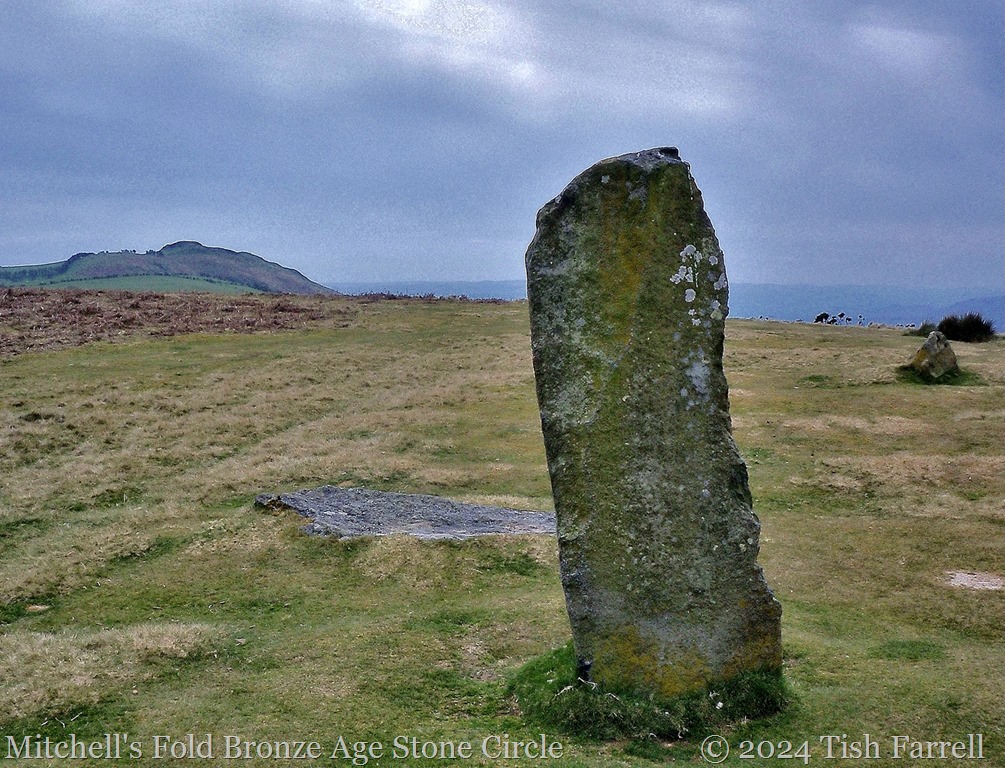
Of course these days  we know that removing tree cover contributes to climate change and environmental degradation, by altering rainfall patterns, and accelerating soil erosion. But in this case global climate change was also a factor.  During Neolithic-Early Bronze Age times it seems the climate was much warmer, with these uplands offering a more benign environment than today. A quick look at an ordnance survey map shows that Bodmin was a very busy place back then. There are numerous hut circles, burial cairns and tumuli, tor enclosures, stone-walled field systems, ceremonial stone circles and standing stones.

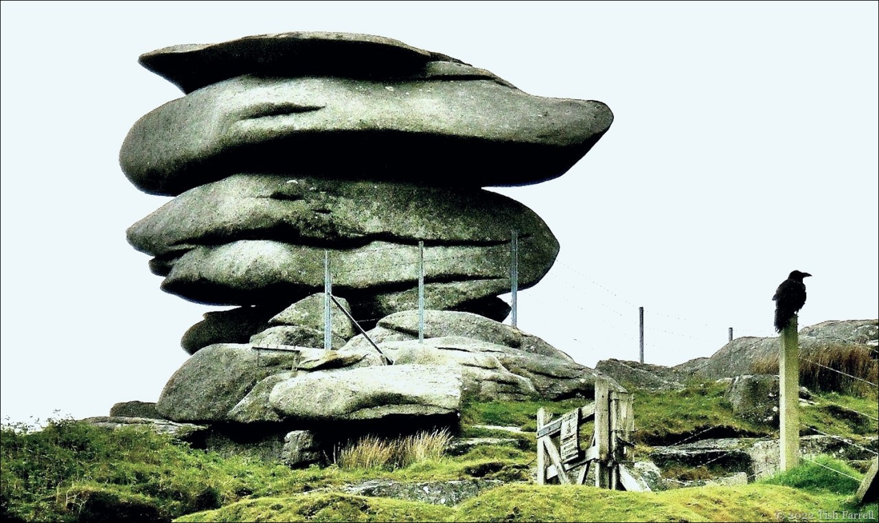
The siting of burial monuments, in particular, was very important – often on the skyline to be seen from one monument to another; or else related to a naturally prominent feature such as one of the stone tors. The Cheesewring Tor is a good example. It lies due north of The Hurlers circles. You will soon see why this weathered granitic pile of rocks captured the imagination of the ancestors, just as it captures ours today.

But there may also have been practical considerations too. When it came to the gathering of clans and families for important occasions, the visibility of man-made and natural features in a landscape without highways would have been the prehistoric equivalent of SatNav.

P1080012

P1070999

Looking southwest from the Cheesewring this is what you see on the skyline beyond the quarry: a series of round barrows:

P1080013

But sometime around 2000 years BCE, the climate began to deteriorate and humanity moved to settle more low-lying areas. It is an interesting irony that the combination of human action and natural climate change which rendered the abandoned uplands unsuitable for anything other than grazing, thereby led to the survival of so many of the prehistoric remains.

Farming, though, is not the only agency of landscape change in this area. Shunt forward to the mid-nineteenth century and you will spot the evidence for quite a new kind of invasion. There’s a clue in that first photo of The Hurlers. Here’s another glimpse:

P1070972

And closer still:

P1070995

This is the Houseman’s engine house, part of South Phoenix Mine, now partially restored as the Minions Heritage Centre. It one of many such mines in the locality, their ruins as dramatic in their way as the stone circles and tors.  For fifty years, between the 1840s-1890s, Minions was the centre of a booming copper mining industry. Over 3,000 people were employed here, including women and children.

Hundreds and thousands of tons of copper ore was extracted, and exported down to Liskeard and the coast at Looe by means  of the ‘Cheesewring Railway’ otherwise known as the Liskeard & Caradon Railway. It was opened in 1844, operated initially by gravity and horsepower, and also carried granite and tin. You can just see part of the granite quarry below the Cheesewring tor. Other signs of Minions’ industrial heyday of miners, quarrymen and railway workers are the humps and bumps of abandoned spoil heaps. The nearby settlement of Minions is also evidence of the industry – it grew up around the junction of several branch lines to house the influx of workers. It is the highest village in Cornwall, and today has a rather desolate air.

P1070994

And now for another kind of heritage: legend. There are all sorts of stories connected with Bodmin’s man-made and natural features. I mentioned the origin of The Hurlers in the last post. The Cheesewring tor has also inspired all manner of explanations. One story tells how it was created by Giants and Saints at the time in the early Dark Ages when Christianity was spreading through the land.

The Giants, who were used to tramping about their domain, and doing just what they pleased, were fed up with the Christian Saints invading their land, putting up stone crosses, and declaring all the wells holy. They called a council to decide how to rid Cornwall of the nuisance.

And to this council there dared to come the frail St. Tue. He challenged Uther, the strongest of the Giants, to a trial of strength. They would have a rock hurling contest.

Rock hurling was one of the Giants’ favourite pursuits. Also, seeing the slightness of Saint Tue, the Giants were sure they would win.

Saint and Giant thus then took turns to throw six very large quoit shaped rocks across Craddock Moor and onto Stowes Hill, but to Uther’s surprise the little Saint soon proved a formidable opponent. By the time the Giant came to throw his last rock, his strength was failing. To the sounds of much Giantly groaning, his stone tumbled from the pile. Tue then  went to make his final throw. The rock was huge, but just as it seemed that the task was beyond him, an angel appeared and placed the rock on top of the pile. The Giants were so overawed by the sight of angel wings casting their golden glow about the place, they conceded to the Saints, and by this means Cornwall became a Christian land.

Another yarn has it that if you visit the Cheesewring at sunrise, you will see the top stone turn three times. This is more up my street myth-wise, and I truly would like to be there at dawn to see what happens, and also to hear the wind on the stones making them resound and mutter.

P1080008


copyright 2017 Tish Farrell

Daily Post: Heritage


This slideshow requires JavaScript.


Of Men Turned To Stone And A Cup Of Gold

P1070982

We were spending a few days in south-east Cornwall last week and, in between downpours, we managed a trip up to Bodmin Moor to visit The Hurlers. This unique prehistoric site comprises three stone circles set out in a row, and dating from the Late Neolithic or Early Bronze Age. This would make them around 4,000 years old. It is impossible to capture the full complex without aid of  hot air balloon or hang glider, so here are some piecemeal shots. Also the light, as you can see, was pretty poor.

The local explanation for the origin of these stones is that they are petrified men – turned to stone in punishment for playing hurling on a Sunday. (Cornish hurling is an ancient team game played with a silver ball. See the link for more details. And no, I don’t think that is an ancient hurler on the skyline).

P1070972

IMG_4692

The circles are 33, 42 and 35 metres in diameter (108, 138  and 115 feet respectively), and none have all their stones intact. The central circle is the best preserved with 14 standing stones and 14 marker stones. This circle and the one to the north of it align with the huge Bronze Age Rillaton Barrow, visible on the skyline to the north-east. It was here that one of the British Museum’s most precious treasures, the Rillaton Gold Cup was discovered during excavations in 1837. At that time it was passed as treasure trove to King William IV and so remained in the royal household. It was only a hundred years later, after the death of George V in 1936 that its full historical significance was recognised. HRH had apparently been using it as a receptacle for his shirt and collar studs.

779px-Rillaton_Cup[1]

Photo: Creative Commons      Rillaton Gold Cup circa 1700 BC


Thursdays’ Special: Traces of the Past – Please visit Paula to see her dramatic view of San Geremia church in Venice, plus other bloggers’ posts of relics of times past.