Charlotte Bronte Was Here ~ North Lees, Hathersage 1845

P1080850

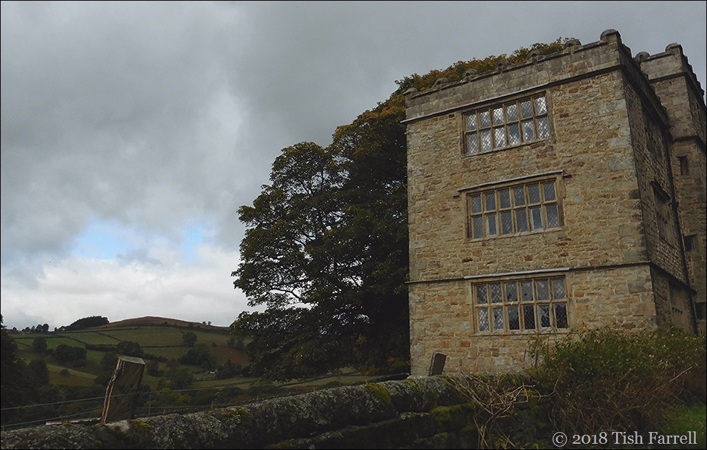
I stepped over the threshold. It was a fine autumn morning; the early sun shone serenely on embrowned groves and still green fields; advancing on to the lawn, I looked up and surveyed the front of the mansion. It was three storeys high, of proportions not vast, though considerable: a gentleman’s manor-house, not a nobleman’s seat: battlements round the top gave it a picturesque look.

Charlotte Bronte’s description of Thornfield Hall from Jane Eyre

P1080848

I’ve written about this before – that the Derbyshire village of Hathersage and its bleak high moors seem to have provided Charlotte Bronte with much of her setting inspiration for Jane Eyre (See earlier post Jane Eyre was here: or was she? ). But on our recent trip to Derbyshire I had the chance to have a look at North Lees for myself and take these photos.

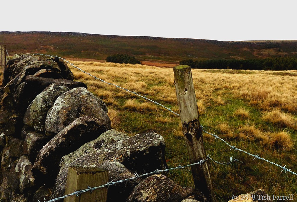
The house sits on a wooded  hillside above Hathersage and below the millstone scarp of Stanage Edge. There is the sense of great isolation there, and it was anyway not a good day for photographs. But my timing was apt given Bronte’s description.

P1080821

Jane Eyre was published in 1847. In 1845 Charlotte Bronte spent three weeks in Hathersage, staying with her old school friend Ellen Nussey, the vicar’s sister. The vicar himself, Henry Nussey, was away on his honeymoon. He had apparently once proposed to Charlotte and been rejected. His absence from the vicarage may well have been chosen for an opportune time for her visit. The two friends then did the rounds of local worthies, including more than one visit to North Lees Hall.

At the time George Eyre, his widowed mother and two sisters were living there. The Eyres had lived in the house since 1750. During the 1400s members of the same dynasty had lived in the manor house that preceded the present hall which dates from around the 1590s. During one of Charlotte’s visits she is said to have been told the grim tale of a previous ‘lady of the house’, one Agnes Ashurst, who became mad and was confined on the second floor, in a room with padded walls so she would not injure herself. Like Edward Rochester’s wife in the novel, she apparently also died in a fire.

Clearly it was a story too good to waste. It is also an excellent example of how writers hoard everything and anything that resonates:  tales, impressions, details of vistas and people, all to be reworked in the ‘world building’ process of creating a convincing context for their narrative.

Knowing that a writer’s source of inspiration could be a real place does not add to our appreciation of the novel; for some it may even detract, and especially if they subscribe to the (false) notion that fiction writers make everything up. Of course they don’t. Immaculate conception without source material to inform the creative process simply does not happen. Here’s some more description of the hall’s surroundings:

Leaning over the battlements and looking far down, I surveyed the grounds laid out like a map: the bright and velvet lawn closely girdling the grey base of the mansion; the field, wide as a park, dotted with its ancient timber; the wood, dun and sere, divided by a path visibly overgrown, greener with moss than the trees were with foliage.

Charlotte Bronte Jane Eyre

P1080849cr

copyright 2018 Tish Farrell

On Derbyshire’s Moors And A Change In The Weather

We were driving over the moors below Stanage Edge and stopped to take in the view. In this first shot to the east  it was all lowering skies and rain in the air. And then I turned on the spot through 180 degrees and took this next shot.

P1080872cr

It was hard to believe, the Hope Valley as evanescent as a soap bubble, as if the sun was shining only on that place. To the left you can see the cut through the upland – the wild Winnat’s Pass, scene of real and legendary tragedies. On the right is Mam Tor with its scree-scarred face. If you squint you can just make out the ramparts of an Iron Age hillfort on the green plateau top.

Further back along the road above North Lees Hall I had tried to take a photo of Stanage Edge. The light was poor and it was not co-operating. And then there was a moment, and the Edge emerged like the mythic backdrop in some Renaissance painting. It is a shape-shifting place, the Peak District.

P1080864cr2


Lens-Artists: Change This week Amy asks us to show her change, however it strikes us.

Disconnected Sunday: Plane…Sheep…Cloud…And Then…?

P1050650

I was attracted by the sheep doing an ovine impression of Landseer’s Monarch of the Glen –  as spotted last week during our short break in the Derbyshire Peak District. Its posing place of choice is Hordron Edge, below Moscar Moor and Stanage Edge. We were walking up here on what he-who-is-usually-the-team-leader suspected would turn out to be a Tish-type wild goose chase. In short we, or rather I was in pursuit of a Bronze Age Stone Circle, otherwise known as the Seven Stones despite the fact that there are apparently eleven stones in the circle, and three more besides nearby.

I should admit straight off that I’m not renowned for my accurate map-reading, and so once we’d passed the sheep, walked for ages in surprisingly hot sunshine for late September, and then found ourselves on a path which kept wending onwards and upwards with absolutely no sign of a megalithic monument anywhere on the sky-line where I was expecting it, even I began to think I’d misread the map, and that we were definitely on a wild goose chase. Worse still, we’d left the lunch picnic in the car, so there wasn’t even the possibility of making the best of a bad job. And it was just the day for a moorland picnic too, not a state of affairs you can rely on in England’s uplands whatever the time of year.

‘We’ll just go to the next bend’ – I said – ‘so we can see over the brow of the hill’. But as always happens in such situations, we never came to the bend’s end. In fact the path began to rise very steeply. Then we noticed that exposed here and there beneath the turf were signs of a stone-paved trackway. Very puzzling in this middle of nowhere, but at least it suggested that we were headed somewhere. (I surmised later that it must be the relic of an old packhorse road up to Stanage Edge whither the locals once went quarrying to make millstones and grind stones).

And so as we pushed on, drawn on by the stone road, and quite unexpectedly Moscar Moor and Stanage lay before us. It is an awe-inspiring landscape, and so it is scarcely surprising that this whole area is rich in prehistoric cairns, circles, and settlement remains.

Also, by now I could see that my map-reading had been spot on, although the stone circle really took some finding in the heather.

P1050637 (2)

So I hope you weren’t expecting Stonehenge. Because here it is – the Seven Stones Circle of Hordron Edge, probably dating from around four thousand years ago.

IMG_3319

The tallest stone is the one seen here in the foreground, and is about 1 metre high. It stands on the south west edge of the 16 metre circle, and has been dubbed the Fairy Stone. You can see it on the far right in the middle ground of the next photo. P1050638

Its particular significance is taken to be its relationship to the two conical hill tops, Win Hill on the left and Lose Hill on the right, the top of the stone possibly mirroring the landscape features. Peak District archaeologist John Barnatt has apparently observed that at the traditional start of winter and spring, the times of age-old festivals, the setting sun appears to roll down Win Hill.

Perhaps the placement of stone had something to do with the gathering of sun-power? Or the marking of the seasons in relation to the farming calendar? We can never know. All we can be sure of is that these monuments were important to the people who created them – gathering places for discourse, rituals, trade, or all of these. More recent local folklore has its say too – hence the naming of the Fairy Stone, and tales of strange lights being seen around about it.

And what do these monuments say to me? Well the main thing is that we should never underestimate the capacities of our ancient antecedents. Also that we should never equate current technological whizz-kidery with intellectual superiority. These people  of the past  knew how to make a life in this challenging territory – a life charged with meaning and a deep sense of their place in the landscape. I feel too, we have lost much of our ancestors’ capacity for poetry and metaphor – the exchange between fellow humans that relied almost exclusively on language – the songs sung, the tales unfolded, the riddles set, the nuances of double and treble meanings.

But before I get too carried away with highfalutin notions, we decide that lunch is now too far away for comfort. We retrace our steps down the old stone trackway. It perhaps does date from much more recent medieval times. I’ve been unable to find out anything about it, although there is medieval packhorse road along the top of Stanage Edge.

As I descend the steep hill on a sunny Indian Summer day I wonder what it must have been like to urge pack horses up this route in a blizzard, the wind slicing under your cape, threatening to snatch your bonnet, the biting cold, the darkness. Just imagine…

IMG_3311 - Copy

copyright  2016 Tish Farrell

Hordron Edge Circle
Bronze Age Stone Circle
East of Ashopton, Derbyshire  OS Map Ref SK21528685
OS Maps – Landranger 110 (Sheffield & Huddersfield), Explorer OL1 (The Peak District – Dark Peak Area)