Nice To Meet Ewe…

Stiperstones 2

*

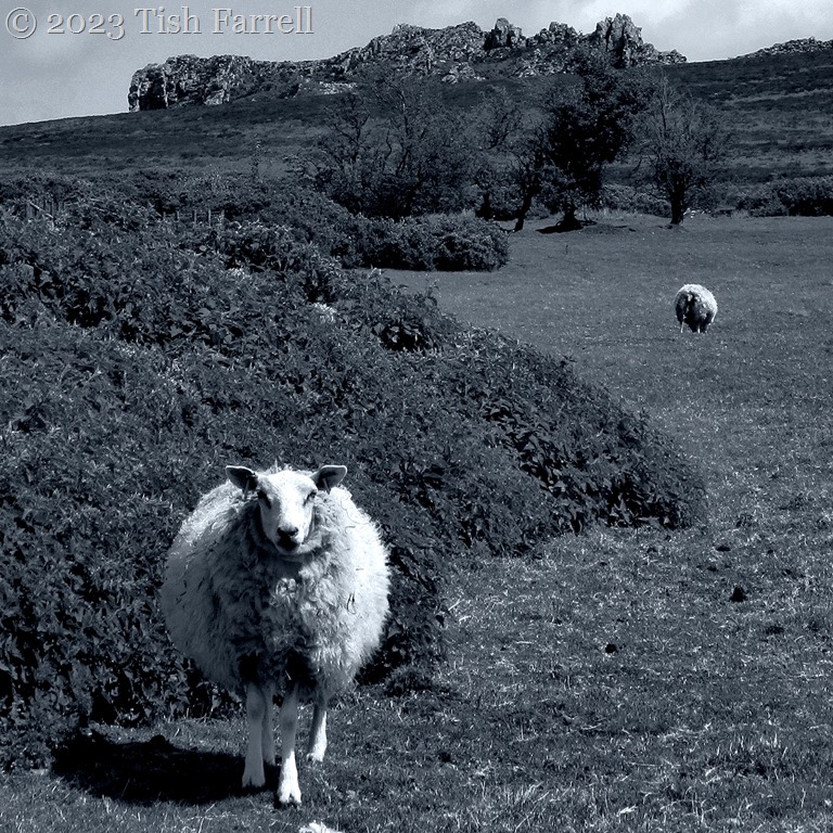
The sheep eyeing me here is posing so neatly beneath the rocky outcrop of the Devil’s Chair. She is clearly untroubled by that landmark’s eerie and supernatural  associations.

This is a stunning landscape, the hills rolling westwards out of Shropshire and into Wales. But it is no easy place to live, the ground marginal, rocky and exposed to all weathers. These days, many farming families struggle and must deploy much ingenuity to keep a viable foothold in the small upland communities, sheep being the primary source of income. Yet, as managed wildernesses go, this is surely priceless terrain; rightly protected and designated an Area of Outstanding Natural Beauty.

It is also a landscape that has been inhabited across five and more millennia. The prehistoric people who lived here left us many signs of themselves – their cycles of living and dying, their field systems and burial cairns, house circles, standing stones, hillforts and henges. The fields, in particular, appear to be at altitudes too exposed for successful cultivation. But then there is also evidence from various post-glacial times indicating the climate was warmer than today, particularly during in the Bronze Age. So perhaps those prehistoric farmers did enjoy their place in the upland sun and a spell of good growing and grazing.

Shropshire hills

There are other historical ironies. The whole locality is riven with old lead mine shafts and workings, some dating from Roman times, but most belonging to the lead mining heyday in the 1850s when the nearby Snailbeach Mine employed 500 men and was known as the richest land per acre in Europe. It is hard to comprehend this now.  Other valuable minerals were also extracted: barytes (the main source of barium used in the taking of X-rays), zinc, calcite, fluorspar and even some silver.

Now lamb chops are the primary resource along with farmhouse B & Bs catering for holiday hikers and cyclists. But also, we can be glad to hear, after many difficult years, hill farmers are now being given credit and support as they continue to farm environmentally protected landscapes.

Here’s a nice story of smallholder Hare Hill Farm and how its owners are making a living with sheep and vegetable growing.

*

a

*

Corndon Hill, Powys border sheep country.

Photo taken from Mitchells Fold Stone Circle

*

P1080526

By contrast, the easterly parts of Shropshire below the hill country, are plain-like. As you can see, it is largely farm fields and scattered habitation. Most production is arable (wheat, barley, hay, oil seed rape, root crops including sugar beet, maize) with some beef, pig and dairy farming.

Photo taken from Shropshire’s most famous hill, the Long Mynd.

*

And now for a favourite sheep photo. One of a flock of sheep, so I was told, brought from Wales to Much Wenlock for a spot of sheltered winter grazing on the Wenlock Abbey estate.

sheep

*

To find out more about Shropshire’s Area of Outstanding Natural Beauty and all the things that go on in our beautiful uplands, take a look at the AONB site HERE. Lots of stunning photos.

*

Cee’s Black & White Photo Challenge: all things farm related

Ups And Downs On The Broseley Jitties

Ding Dong steps 2

The Broseley Jitties are quiet these days. On our early evening rambles we meet only a now-and-then walker with their dog. And then perhaps a stray chicken. Or a watchful cat in a cottage gateway. The atmosphere is somnolent; a sense of falling back through time. There’s the subtle scent of cow parsley along the verges,  of garden flowers wafting over the walls and hedges.

Yet a hundred/two hundred years ago there would have been no quietness (or cleanly odours) here. Only the shouts and chatter of working men, women and children; rattle of clogs as the folk of Broseley Wood went about their day – to the mines and quarries, to the pot and pipe factories, to the taverns, to the chapels, to the wells.

Ding Dong Steps

*

Botswell Lane Jitty down and up – and as the name denotes, a main route for fetching water from the well in the valley bottom. Hard work fetching washing and cooking water, especially in the winter.

Botswell Lane

Botswell Lane up

*

Another water source was the spring on Spout Lane, not far from the bottom of Jews Jitty where the Wolfson family lived and ran their pottery factory.  The daughters of the house apparently carried out the ritual bathing rite of mikvah at this spring – a somewhat public spot.

spout lane spring

*

Jews Jitty up…

Jews Jitty up

*

And Jews Jitty down …

Jews Jitty sepia

*

And a final up on Gittings Jitty yesterday evening, the cow parsley in full flourish…

Gittings Jitty

Cee’s Black & White Photo Challenge: steps or ladders

Into the Light On The Mawddach Estuary

mawddach6

The Mawddach Estuary in mid-Wales is one of my favourite places. We stayed there for a few days last October.

On the southern shore there’s a fabulous footpath, the Mawddach Trail that starts in Dolgellau and follows the long-gone railway track. You can walk all the way to the coast and cross into Barmouth via the old viaduct, and then catch the bus and travel back to Dolgellau following the northern shore line. The trail is flat and even and accessible to all.

Mawddach trail sepia

Cee’s Black & White Photo Challenge: Vanishing Point

A Fountain Fit For A Tsar…?

P1080754 ed1

It might have been a protocol blunder of imperial proportions, but then it tells you much about the man almost responsible for it. And so it was that when the high-spending William Cavendish, 6th Duke of Devonshire, thought Tsar Nicholas would  visit his Chatsworth domain in 1844, he commissioned Joseph Paxton to build the world’s tallest fountain; this to outdo both Chatsworth’s existing Great Fountain (then the tallest in Britain) and the Tsar’s own grandest fountain at his Peterhof Palace in St. Petersburg. So: a back-handed sort of honouring, and I wonder how the Tsar would have taken this spectacle of extravagant one-upmanship: smiling through gritted teeth perhaps?

He anyway did not come, although the fountain was named ‘the Emperor’ to mark the non-occasion. The jet has been known to reach nearly 300 feet, although it was ‘turned down’ on the day I took this photo due to high wind.

For more about Chatsworth and a small family connection see my earlier post To Chatsworth and how Mary Ann went to the ball

Cee’s Black & White Photo Challenge: fountains and sprinklers

Spanning The Straits: Thomas Telford’s Magnificent Menai Suspension Bridge

IMG_2388ed

“…some of the horses are unsettled by the drop…”

Thomas Telford 1826

I’m not one for heroes, but I make an exception for Thomas Telford (1757-1843), the son of a Dumfriesshire shepherd who became one of Britain’s most outstanding engineers, the first President of the Institute of Civil Engineers and the man who left us with many astonishing structures still in daily use. Not the least of his many achievements are Scotland’s 60-mile Caledonian Canal and the magnificent Pontcysyllte Aqueduct whose still working canal crosses the River Dee near Llangollen in Wales.

And then there is the Menai Bridge that bridges the strait between mainland Wales and the island of Anglesey, with arches tall enough to allow ships to pass without lowering their sails. With a span of 580 feet it was, in its day, the longest suspension bridge ever constructed. Work began in 1819 and the bridge was opened to coach traffic in 1826. The project was part of Telford’s major improvements of the road from the Anglesey port Holyhead to London, otherwise known as the A5. One object was to ensure the swift, safe transport of Irish Members of Parliament to Westminster. Before the bridge, they had to risk a perilous ferry crossing between Anglesey and Bangor.

Telford was not only a man of vision in construction terms, but he always looked to the bigger picture, building roads that, though expensive to construct, were well drained and low maintenance, always looking to create integrated transport systems that would bring local and national prosperity. He was fastidious, too, in his project planning, and astute when it came to political lobbying and fund raising. He was also a man who made fast friendships and was a diligent letter writer, and he did much to encourage the young engineers who would succeed him.

In fact he never stopped working. Only death at the age of 77 concluded his prodigious career. There was never time to marry  either (though there were near misses) and only in his late years did he bother to buy his London house. Even then he still kept travelling, racketing around in a coach from project to project, the length and breadth of the British Isles. He was certainly a man who knew his own worth, but he was modest too. Here’s a letter he wrote to one of his Menai Bridge contractors, Nye Vaughn, owner of the Castle Iron Works which provided the iron chains.

My Dear Vaughn,

You will be pleased to learn that the bridge at Menai is finished and opened to mail coaches last month. I confess the admiralty demand to hang the road a hundred feet above the sea to allow sailing ships to pass was a daunting requirement. However the bridge is built and, I must say, I am proud of it. It seems I am to be known as the ‘Colossus of Roads’ ** . An odd name don’t you think? Your iron chains were a devil to hang across the straits but they are firm and there is little movement when the coaches pass across although some of the horses are unsettled by the drop. Thank your son for his suggestion to coat the chains in linseed oil to protect them from corrosion. His idea has proved better than the lead paint we planned to use. To be doubly sure we have done both. When he proposed linseed oil I believed he was repaying me for teasing you in the sealing of Pontcysyllte Aqueduct. I hope you forgive my jest. Please accept my compliments and thank your foundry men. Tell them we found no flaws in the links we tested. When I am next in need of heavy castings I will call on you.

My very best regards,

Telford

** It was Telford’s close friend and poet Robert Southey who coined this term Colossus of Roads

When we were on Anglesey back in January the bridge had been closed for three months. It was quite an emergency. Some structural upgrading carried out during the war years 1938 and 1941 showed serious signs of failing. Brittle hanging sockets were the problem and “analysis showed there was a credible risk of an unzipping failure of the bridge deck.”

An unzipping suspension bridge of Menai’s scale sounds horrendous. It’s good to know the bridge is now back in business. It opened again at the start of February. All the same, I wonder what Thomas Telford and Nye Vaughn would have had to say about brittle hanging sockets.

IMG_6517ed


Cee’s Black & White Photo Challenge: Arches, domes and half circles

Passing On The Saxon Past: Some Mystifying Fragments

Wirksworth Saxon carvings

Here’s a fine thing: Saxon carvings some 1,300 years old, but recycled in the 13th century when Wirksworth’s ancient church was being rebuilt. The curious fragments have been popped into one of the main inside walls, a cobbled assemblage of ram’s head, a wolf (or boar?), a leopard-like creature, a horse, and in their midst, a royal couple (?).

It is thought the carvings came from an early Christian building or Saxon cross. Wirksworth, in Derbyshire’s Peak District (England’s East Midlands) was once part of the great Saxon kingdom of Mercia, whose kings and sub-kings held sway over much of England from CE 600 to 900.

Christianity was established there in the mid 7th century as a condition of a peace treaty between pagan Mercia and neighbouring Christian Northumbria. Northumbrian Princess Elchfrida travelled south into Mercia to marry Peada, son of Penda, the last great pagan king of Mercia. She brought with her an entourage of missionary priests, one of whom, Betti, founded the church at Wirksworth in CE 653.

So could the couple be Elchfrida and Peada? We’ll never know. Though we do know from Bede that the real-life Elchfrida later betrayed Paeda, which led to his death and the reassertion of Mercian supremacy under his brother, King Wulfhere.

*

Wirksworth coffin lid

*

The church has another mysterious Saxon treasure, known as The Wirksworth Stone. It is a coffin lid dating to around CE 800, found a thousand years later during building work. The lid covered a large skeleton whose burial position under the floor close to the altar suggests a person of high religious status, an abbot perhaps.

Wirksworth Saxon coffin lid

But looking now at these curious works, and pondering, too, on my likely Anglo-Saxon origins, I can’t help but think of the opening line from L.P. Hartley’s novel The Go-Between:

The past is a foreign country; they do things differently there.

Wirksworth St Mary's

St. Mary’s, Wirksworth

Cee’s Black & White Photo Challenge: statues, sculptures and carvings

The Day The Sun Fell Into Henllys Woods And Other Light Shows

Henllys Woods

It is said that the Druids faced their final battle with the Roman Army on the North Wales island of Anglesey in 60-61 AD. According to Tacitus, things did not end well for them and their sacred oak groves. [See my earlier post Island Of Old Ghosts]. Early on in the invasion of Britain, the island had become a refuge for resisting Celtic warriors, doubtless assuming that the Menai Strait would present an obstacle to the legions. (It didn’t).

But for the Druids – the seer-diviner-lore-keeper-law-makers of the community, I tend to wonder if it wasn’t the island’s more extraordinary characteristics that they drew on. The quality of the light for one, and especially in winter when the sun over sea and strait and mainland mountains creates some mesmerizing effects, even when caught in monochrome.

P1060396 - Copyc

P1060522sep

100_5262

Henlyss Woods 2

Cee’s Black & White Photo Challenge: Light