When Creator Comes Visiting…

Mt Kenya

…this is one of his domains – the craggy summit of Kere-Nyaga, Mountain of Brightness, better known outside East Africa as Mount Kenya.

And the supreme being concerned is Ngai, maker of earth, the cosmos and everything. And it was to Ngai that the Kikuyu farmers of Mount Kenya’s southerly foothills once offered their sacrifices and prayers. Although they only did this in times of great crisis, since it was generally held that Creator was a remote figure, little concerned with human affairs. When his help was sought, he was addressed as Mwene-Nyaga, possessor of brightness (Jomo Kenyatta, Facing Mount Kenya 1938). Nyaga also has figurative connotations, meaning ostrich, but in this context suggestive of the white plumes of the male ostrich, a visual analogy for the glaciated zones among the dark mountain peaks.

You’ll see the thinking in this next photo:

ostrich and Ngong hills best

This shot of a retreating male ostrich also captures a distant view of the Ngong Hills, another landmark of spiritual significance, not least in recent times to Out of Africa  writer Karen Blixen and her lover Denys Finch Hatton whose burial place it is. For that story see Caught inside a Kikuyu garden.

I’m sorry I don’t have more and better photos of Mount Kenya. The ones I do have are a little odd, as if the mountain meant to tease by showing off parts of itself at times and in places where it was not expected to be. I remember spotting it early one morning as I stood in the garden of the Outspan Hotel in Nyeri, the jagged summit floating gauzily above the horizon.

For several moments I was fixed to the spot. By the time I thought of taking a photograph it was gone – only empty sky in the place where it was, and a visceral sense of loss. Kilimanjaro just over the border in Tanzania, plays the same trick. Both mountains spend much of their time being mysteriously invisible. Yet there are travellers’ tales that claim occasions when, looking north and south, both mountains appeared simultaneously. Just imagine!

002 (2) ed

*

And now for the Mount Kenya photos I do have. The first one was taken from a small plane on our way to Lewa Downs:

Mt Kenya from plane

Grevy's Zebra and Mt Kenya

Mount Kenya and elephants

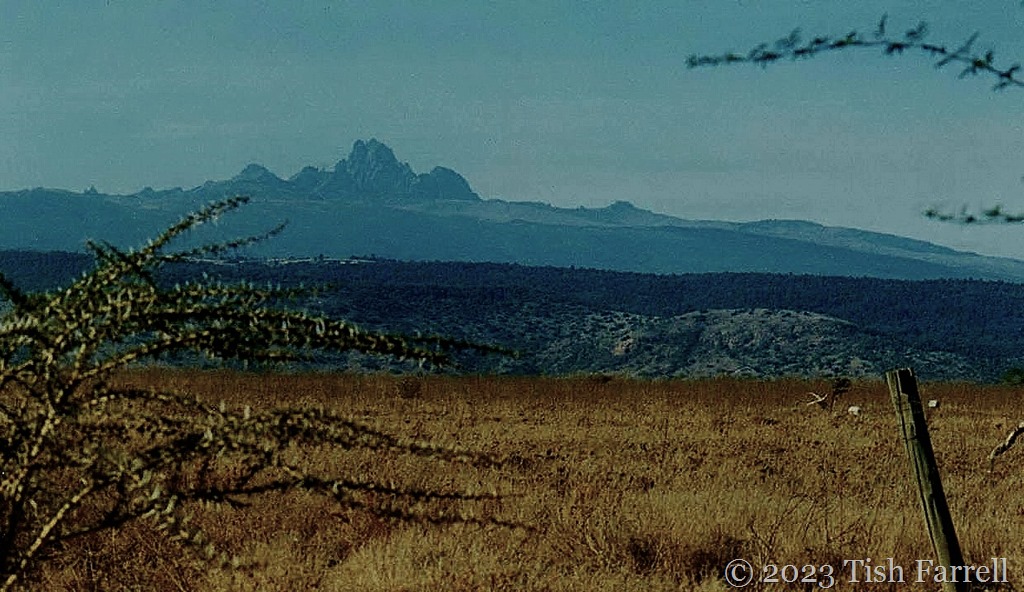
This photo was taken beside the Lewa Downs air strip. At the time, it was the two elephants, just visible in the foreground, that caught my eye. It was only when I was scanning the image that I noticed the odd geographical juxtaposition of Mount Kenya’s summit. What are its lofty peaks doing just there, and so sneakily? They are over 17,000 feet high.

*

Kenya Aberdares

And finally a sunset view of Mount Kenya from the neighbouring Aberdares National Park. The Aberdare Range is also one of Creator’s dwelling places when he is checking out earthly doings. Its Kikuyu name is Nyandarua, which I believe means place of the crumpled hide – another interesting metaphor. Here’s an aerial view:

Scan-130608-0051

These vivid names for spiritual landscapes remind me that in traditional pre-literate societies, the natural world provided humans with unlimited scope for pondering, creating and observing. Its diverse parts were sources of inspiration and expression, things to think by, a resource for metaphor, analogy, riddles, song, dance and story telling as means for making sense of existence.

Particular mountains, trees, rocks, lakes, chosen as places to make sacrifices or pray to Creator, are gateways to congress with the divine, and so may be taken as sacred in the same way a church is sacred space for a Christian. More broadly, though, all land may be seen as sacred since it was made and given to humans by Creator.

And in this sense, then, there is no divide between spiritual and physical; all states exist in the same plane, which is interesting, if somewhat difficult for some of us to think about. We might call it respect. We might even call it love.

*

Lens-Artists: Spiritual Sites   Tina sets this week’s fascinating theme. Please take a look at her inspriting post.

Nice To Meet Ewe…

Stiperstones 2

*

The sheep eyeing me here is posing so neatly beneath the rocky outcrop of the Devil’s Chair. She is clearly untroubled by that landmark’s eerie and supernatural  associations.

This is a stunning landscape, the hills rolling westwards out of Shropshire and into Wales. But it is no easy place to live, the ground marginal, rocky and exposed to all weathers. These days, many farming families struggle and must deploy much ingenuity to keep a viable foothold in the small upland communities, sheep being the primary source of income. Yet, as managed wildernesses go, this is surely priceless terrain; rightly protected and designated an Area of Outstanding Natural Beauty.

It is also a landscape that has been inhabited across five and more millennia. The prehistoric people who lived here left us many signs of themselves – their cycles of living and dying, their field systems and burial cairns, house circles, standing stones, hillforts and henges. The fields, in particular, appear to be at altitudes too exposed for successful cultivation. But then there is also evidence from various post-glacial times indicating the climate was warmer than today, particularly during in the Bronze Age. So perhaps those prehistoric farmers did enjoy their place in the upland sun and a spell of good growing and grazing.

Shropshire hills

There are other historical ironies. The whole locality is riven with old lead mine shafts and workings, some dating from Roman times, but most belonging to the lead mining heyday in the 1850s when the nearby Snailbeach Mine employed 500 men and was known as the richest land per acre in Europe. It is hard to comprehend this now.  Other valuable minerals were also extracted: barytes (the main source of barium used in the taking of X-rays), zinc, calcite, fluorspar and even some silver.

Now lamb chops are the primary resource along with farmhouse B & Bs catering for holiday hikers and cyclists. But also, we can be glad to hear, after many difficult years, hill farmers are now being given credit and support as they continue to farm environmentally protected landscapes.

Here’s a nice story of smallholder Hare Hill Farm and how its owners are making a living with sheep and vegetable growing.

*

a

*

Corndon Hill, Powys border sheep country.

Photo taken from Mitchells Fold Stone Circle

*

P1080526

By contrast, the easterly parts of Shropshire below the hill country, are plain-like. As you can see, it is largely farm fields and scattered habitation. Most production is arable (wheat, barley, hay, oil seed rape, root crops including sugar beet, maize) with some beef, pig and dairy farming.

Photo taken from Shropshire’s most famous hill, the Long Mynd.

*

And now for a favourite sheep photo. One of a flock of sheep, so I was told, brought from Wales to Much Wenlock for a spot of sheltered winter grazing on the Wenlock Abbey estate.

sheep

*

To find out more about Shropshire’s Area of Outstanding Natural Beauty and all the things that go on in our beautiful uplands, take a look at the AONB site HERE. Lots of stunning photos.

*

Cee’s Black & White Photo Challenge: all things farm related

Lens-Artists: What’s Bugging You?

IMG_9780cr

I don’t need to be asked twice to reprise photos from my bugs and butterflies archive. And this week at Lens-Artists, Donna is doing the asking.

IMG_2780cr

Comma butterfly on Doronicum ‘Little Leo’ aka Leopard’s Bane.

*

IMG_9331

Peacock and the bee.

*

100_6631cr

Marmalade hoverfly visiting the crocosmia, a variety which I’m pretty sure also had marmalade in its name.

*

IMG_1485

And another kind of hoverfly on a lace flower.

*

IMG_3103

Elephant hawk-moth found one day on the garden wall.

*

IMG_8834cr

This ladybird has found the perfect ‘platform’ on a Dyer’s chamomile daisy.

*

IMG_0670

IMG_1263

White-tailed bumble bee ‘bathing’ in Hollyhock pollen.

*

100_3915

We could call this a bee line: oriental poppy here we come. BZzzzzz!

*

Lens-Artists: What’s bugging you? That’s this week’s question from Donna at Wind Kisses. Go see her fine gallery of close-up bugs, bees and butterflies.

This Was May, But Is It Spring?

IMG_3313

It certainly looked like spring as we pursued our May explorations of Broseley’s lanes and jitties – but then looks can deceive. The trees in these photos may be bursting with greenery, the hawthorns hanging in blossom, and the cottage gardens bright with late spring flowers: Welsh poppies, columbines, clematis and wisteria, but this past month has been COLD. Even on the sunniest days we have had winds that feel as if they have just blown over an ice field. In fact, come the first of June, we switched the central heating back on for a spell.

Still, we’ve not let draughty climes stop our walks. We’ve made some special finds too, in particular the Haycop Nature Reserve, a wooded ridge a short walk from the High Street. It was once a coal mine (1760-1860), the coal extracted from it coked and used for firing two nearby blast furnaces. Later it was used to fire local brick kilns.

The mine shafts were capped in the 1970s and the ground reverted to grazing land. Then in 2007, the Haycop Conservation Group began restoring the natural habitat, including the pond that had once been the holding pool for pithead winding gear. This week when we visited the flags were definitely ‘flying’:

IMG_3370 cr1

IMG_3369cr

IMG_3363

*

The 9-acre site is a warren of trails through mature woodland, meadow and heath, the main paths smartly sign-posted at intervals, and provided with information boards highlighting the local wildlife, including several varieties of butterflies, moths and dragonflies and some 58 bird species, among them sparrowhawks and nuthatches. From the top of the ridge there is a fine view of the parish church, All Saints, built in 1745 and an excellent example of the perpendicular:

IMG_3383

IMG_3378

IMG_3385

IMG_3381

*

Looking at these views now, it’s hard to envisage Broseley in its industrial heyday (17th to early 19th century), the fumes from steam engines, furnaces, kilns and coking ovens, the clatter of waggons on the network of wooden railways, the carts pushed by humans, hauling coal, bricks and iron through the town to the River Severn.

One of Broseley’s famous industrialist residents was John ‘Iron Mad’ Wilkinson, who pioneered the use of cast iron, including the first iron boat, and the accurate boring of cannon. By way of thwarting any attempts of industrial espionage, his two furnace sites were in secluded spots just outside Broseley at Willey, on land owned by the lord of the manor. From 1763 he lived in the town, not far from the church, leasing a rather grand house called ‘The Lawns’. Nearby was a building wherein he operated a mint, producing his own token currency, a common practice among ironmasters to keep their workforce in thrall.

IMG_3268

The Lawns was first leased by John Wilkinson in 1763. Later it was the home of porcelain manufacturer, John Rose, who founded the nearby Coalport China Works

*

IMG_3271

John Wilkinson’s mint, next door to The Lawns.

*

IMG_3321

This town boundary sign takes a bit of spotting; the hawthorn hedge is definitely winning.

*

And now for a few ‘hanging’ roofscapes in and around the Broseley Wood jitties:

IMG_3283

IMG_3312

IMG_3320

Speeds Lane – John Wilkinson’s personal railway apparently ran down here to the River Severn – the waggons loaded with iron from his Willey Furnaces

*

And to finish – another visit to the Quarry Road duck and hen ‘farm’:

IMG_3395

The Changing Seasons: May 2023

Kindly hosted by Brian and Ju-Lyn. Please go and see May in their respective home territories – Australia and Singapore.