living textures: ageing with dignity

Scan-140727-0008


Today, 10 August 2014,  is World Lion Day, and I’m posting this photo of a rather threadbare old lion. He might look world-weary lying here in the Mara oat grass, but he still conveys a sense of the powerful creature he once was. Of course in these days when humanity and wildlife increasingly compete for territory, it is wishful thinking to hope that all lions might live out their natural life span in the wilderness they have left to them.

World Lion Day

DP weekly photo challenge: texture


did anyone know private victor rowles 1896-1915?

SHOT AT GALLIPOLI, BATTLE OF LONE PINE,  8TH AUGUST, 1915

IMG_0568   My Great Uncle Giles (Victor) Rowles left little trace of himself on this earth. There is only this childhood photograph inside my great grandmother’s locket. For one thing he lived so briefly. Nineteen years. For another, he does not even have a grave. He was dropped from a hospital ship into the Mediterranean, two miles east of Mudros Harbour off the island of Lemnos. This happened around 10pm on the 10th August 1915 two days after admission. I know this only from the First Australian Imperial Force (1st AIF) records that the Australian National Archives have posted on the internet. I thank them for their dedication and care in making these records so freely available. I have written what little I know of Giles Rowles in two earlier posts, but I have reason to repeat it. On October 15th 1914, Cheshire born Giles (he later, and for unknown reasons, changed his name to Victor) enlisted in the 14th Battalion AIF in Melbourne, and then went directly for training at Broadmeadows. On 22 December 1914 he embarked for Egypt on HMAT ‘Berrima’, arriving there for further training in January 1915. In April the 14th Battalion took part in the landing at Gallipoli, and so began the hell-on-earth siege that achieved nothing but the pointless deaths of thousands of brave young men – Australian, New Zeleanders, French, British and Turkish. 480_2[1]

Landing at Anzac Cove 1915.  Photo: localhistory.kingston.vic.gov.au

*

Conditions at Gallipoli were unspeakable; it was a case of death by sniper, grenade or disease. Giles survived long enough to also take part in the August Offensive. This involved the Australian and New Zealand Army Corps moving up the coast from where they had been dug in for months to attack two peaks of the Sari Bair range while the British and French forces defended Helles. Giles it seems was hit by a Turkish sniper. In the military records he is listed as Private Victor Rowles no. 1402, admitted to the hospital ship Devanha with gunshot wounds. Two days later he was dead. There are several mysteries here. The first is how did this English lad end up volunteering with the AIF in Melbourne? The last certain record I have of Giles on English soil is from the 1911 census. He is listed as 15 years old and working as an apprentice clerk for a shipping broker in Cardiff. He is living with his widowed aunt, Louisa Rowles of 10, Despenser Gardens, where his older cousins, Beatrice a spinster, and John, a shipping agent also live. He is named after his uncle, Louisa’s late husband, Giles, a mariner. The Rowles family, it seems, have generations of seafaring connections. Giles’ own father, Charles, was a retired ship’s captain, and thereafter a pilot on the Manchester Ship Canal. He was my great grandmother’s second husband. As a young widow with three small children and a stepson, Mary Ann Williamson Shorrocks (née Fox) ran the Old Red Lion Inn and farm in Hollinfare (Hollins Green), Cheshire. Her father or brother, (both were named George Fox), had taken up the license in 1894, a year after selling up the family farm of Callow in Derbyshire. At this time Mary Ann would have still been in mourning for her first husband. He had died in his late thirties, a bankrupt shuttle manufacturer. It seems that the Fox family had secured the inn on Mary Ann’s behalf to ensure she had an income. It stood beside a then busy thoroughfare to Manchester, overlooking the new Ship Canal, which doubtless explains how the pretty young widow soon came to catch the eye of one Charles Rowles. IMG_0007

Mary Ann Williamson Fox at Callow Farm, Hathersage, Derbyshire sometime before her first marriage to Thomas Shorrocks, a Bolton spindle manufacturer.

*

The sea captain was much older than Mary Ann, a widower with two grown-up daughters. They married in 1895, but by 1903, when Giles was only seven years old, Charles Rowles lay buried in Hollinfare’s quiet little cemetery. Six years later, Mary Ann joined him. She was forty six. She had died of heart disease at her stepson’s house in Moss-side, Manchester, where her simple-minded sister, and the three Shorrocks children (including my grandmother) also lived. Whether Giles went to live with his Rowles relatives before or after his mother’s death is not known. Certainly he would have finished at Hollinfare village school at twelve years old, and the photo in the locket could well date from that time. It seems likely that the chance of a secure career in the shipping business prompted the move. In 1912 there is a passenger list record for one G. Rowles travelling as labour to Halifax, Canada on the SS Hesperian, but there is no conclusive evidence that this is Giles. I could anyway find no evidence of his arrival in Canada, although if he had signed on as crew, he could have sailed onwards to Australia. A comment by a now deceased aunt repeated the family story that he had chosen to settle in Australia, and this line of enquiry remains to be followed up. By the time Giles enlisted in Melbourne, he had changed his name to Victor. On the enlistment papers he calls himself a sailor, and responds to the question of whether he had ever served an apprenticeship, with a decisive ‘NO’. And perhaps this is the reason for the change of name. Perhaps he broke his apprenticeship, and used the knowledge gained in the shipping office to find a ship and run away to sea? The Broadmeadows medical officer records him as being eighteen years and seven months, 5 feet 5 and a quarter inches, and 135 pounds in weight. His complexion is described as ruddy, his eyes green and hair brown. His only distinguishing marks are two vaccination marks on his left arm. The reason he has given Aunt Louisa Rowles as his next of kin is also a mystery. She was not in fact a blood relative, and I know for a fact that his Shorrocks half-siblings adored him. It must have been they who had the tribute to Giles added to his parents’ gravestone in Hollinfare. DSCF9350 On his death, records say a brown paper package containing Giles’ few effects – a handkerchief, pipe, cigarette case, manicure-set, letters and photos, was later sent to Aunt Louisa, followed by his three service medals, a memorial scroll and plaque. All these items are now lost. He is nonetheless commemorated in his ill-fated name of Victor at Lone Pine Memorial, Turkey and on the Australian War Memorial at Canberra. On his parents’ and grandfather’s stone in Hollinfare it says: “Pte Giles son of the above Charles and Mary A Rowles, who died of wounds received at the Dardanelles on August 10th 1915 aged 19. He hath done what he could.” And why am I posting this story once again? Well surely someone knew Giles Victor Rowles? He must have had mates – at sea, at Broadmeadows, at Gallipoli. Did not some girl love him? Doesn’t his name occur in a fellow private’s letters home? Is there not some diary entry that mentions him? Doesn’t anyone know what happened to his medals? The photo in his mother’s locket shows a boy with determination. His gaze is direct. He looks cherished. And it is his photo in the locket, and not one of his half-siblings. On the other side of the locket, delicate strands of hair from all five children – Robert (stepson), Mary, Lilian, Thomas Shorrocks and Giles – are woven together. Mary Ann would have been able to identify each child from the varying shades of blond and brown. This small locket, then, contains the only physical evidence of Giles Rowles’ existence. 100_6264   #nogloryinwar

copyright 2014 Tish Farrell

BY ALL MEANS SHARE THIS POST, BUT PLEASE ACKNOWLEDGE MY COPYRIGHT

“Wheat…fields of wheat…” Musings on the path to the allotment


100_5994

Okay, who knows which film this quote comes from? As an extra clue I give you the line in ‘full’: “Wheat… lots of wheat… fields of wheat… a tremendous amount of wheat…”

For some reason I cannot explain, this particular exhortation is rather popular in the Farrell household.  The Team Leader is wont to deliver it at unexpected  intervals and with some vigour. This habit even predates the time when we actually came to live beside  a field that often has wheat growing in it. So here is it. The field behind our house. And while I admit it might overstep the bounds of propriety to share my washing with the world, here is another view of the wheat field from our garden. I also think the flower shadows on the sheet rather fine: housework turned artwork?

077 (2)

I have written in earlier posts how our house lies on the edge of Wenlock Edge, a twenty-mile scarp formed from the upthrust bed of a tropical sea – the Silurian Sea in fact. This geological formation is a breath-taking 400  million years old – a place once inhabited by trilobites, and molluscs, and sponges and corals, although it should be made clear that when these creatures lived, the shallow sea in question was not in the northern hemisphere.  No indeed. In its tropical heyday Shropshire lay off equatorial East Africa. We are thus, for all our rustic appearance, a well-travelled county. We also have lots of geology of international importance, but  which I cannot begin to describe because the terminology and chronological expanses confound even me, a prehistorian. The Shropshire Geological Society have  a good site HERE should you wish to know more.

100_2077

The reason I’m showing you the wheat field is because my path to the allotment runs along the edge of it. I walk back and forth at least once a day. And so when I’m not writing blog posts or fiddling with my novel, this is one of the places where I’m likely to be. There is always something that catches my eye – thistles, the light, clouds, buzzards, the rooks and jackdaws, a neighbour’s three white ducks that regularly escape from their pen to eat slugs along the path, cats on the prowl, pretending I can’t see them.

Even the wheat is quite interesting. It amazes me how it manages to force its way up through a cloddy layer of grey clay that bakes to concrete after a few days with no rain. This soil, too, is a product of a geological event – a deluge of  volcanic ash from aeons ago and that has now broken down into bentonite clay.  It is the same soil in the allotment. Soft fruits seem to thrive on it. Everything else is a challenge. Wheat, though, has apparently been grown along the slopes above the town for generations, hence the name The Wheatlands for some of our now built-upon areas.

100_5840

100_5839

And talking of building, a couple of years ago when the Local Authority called for landowners to put forward development land, our local landowner proposed  this and most of the fields on the Edge side of the town, including the allotments too, gardens  that have been there since the 1940s.  Development on this scale is something that most town residents fervently  hope will not happen. We have already been threatened with up to 500 houses over the next 11 years. This in a town with antiquated drainage, severe traffic congestion, few jobs, poor public transport, and inflated house prices, and one that has seen several new developments of upmarket houses in the last few years.  More crucially, the town sits in a bowl below the Edge and has recently been designated a rapid response flood risk area by the Environment Agency.

001 (2)

More tarmac, roofs and roads that speed up run off from the hills above our homes are the last thing we need.  Some of the newest developments in the town are themselves subject to flooding.

100_5849

 100_5995

All right, I admit it. The landscape behind our house is perhaps not particularly noteworthy of itself, but the light and sky above it are. The uptilted scarp of Wenlock Edge forms a false horizon, so there is always much weather to watch. It changes every second. One day we saw a fire rainbow which we gather is quite rare.

Ironically, it it perhaps because this view from our house is ever under threat, that makes us look at it and appreciate it all the more. But it makes me angry too. I am not opposed to development, but it should be well planned, and enhance the locality, not cause problems for other people’s homes. There appears to be no mechanism in English planning that can ensure the provision of good quality housing at prices people can afford. Density seems to be the only planning criterion, not  homes with green spaces around them, and places for community orchards and gardens, footpaths and cycle tracks and areas where people of all ages can play. All things that boost wellbeing. You would wonder why it is so hard to do.

It is true that  Much Wenlock people have recently voted to have the Local Authority  accept their Neighbourhood Plan, a community compiled document that reflects our aspirations and plans for the foreseeable future. Our Conservative Party MP, Philip Dunne, tells us the Plan will deliver localism to our door, that is, we will have a say in the kind and scale of development that is proposed for our town and parish, development that will protect landscapes, open spaces and heritage while improving the quality of life for everyone. Whether it will, or not remains to be seen, particularly under a government whose recently sacked Secretary for the Environment apparently allowed for the destruction of ancient woodland as long as developers replanted elsewhere.  Bio-diversity anyone?

Which I suppose brings me back to the quote; “Wheat…fields of wheat…” You can’t get more of a monoculture than that. Hey ho. So many things to unpick. Think I’ll trundle up the path to the allotment and pick raspberries.

copyright 2014 Tish Farrell

Related:

…of Silurian Shores

Old Stones of Wenlock: repurposing the Silurian Sea

In Much Wenlock an Inspector Calls

100_4193

P.S. The quote is from Woody Allen’s Love and Death


Of Monumental Mysteries

“The past is a foreign country: they do things differently there.”   L P Hartley The Go-Between      

Scan-130804-0007


Scan-130804-0012

So what’s the mystery here? No, not that strange woman in a Welsh felted hat doing tai chi. (Actually,  I think I may be in the process of ‘grasping the sparrow’s tail’ Yang-style long form. I’ve rather forgotten).  I remember, though, the icy winter’s day, and the absolute stillness, and the hazy blue views of Wales over the border from my Shropshire homeland, and the feeling that this circle of ancient stones was a special place; that it stirred in me the sense that doing tai chi here would be a good thing.

I have written before about Mitchell’s Fold Bronze Age stone circle,  and you can find the witchy legend associated with it  HERE.  Historically speaking, little is known about the stones  beyond the fact that they were raised some 4,000 years ago. The surviving fifteen stones form a rough circle, although there may have once been as many as thirty. The tallest survivor is said to have originally been one of a pair, and so formed some kind of gateway or threshold at the circle’s edge.

These henges are, on the whole, unfathomable. There is no knowing how the people, who toiled to build them, made use of them, or what their precise significance was in their daily lives. The elevated location of Mitchell’s Fold, with its sweeping vistas, suggests to us a sacred function. There are also possibilities that the stones’ particular alignment served as some kind of calendar, marking solar and lunar events. And, for more prosaic purposes, in a world without maps and SatNav, prominently sited megaliths may also have provided travellers with landmarks to keep them on course through the upland wilds. The Bronze Age was, after all, a time of intinerant smiths and artisans who covered great distances to trade their goods and services.

Scan-130804-0041

This is borne out by the fact that not far from Mitchell’s Fold, just over the Welsh border in Powys,  is the Cwm Mawr Bronze Age axe factory. The distinctive looking axe-hammers that were made here have been found across Wales and England, their discovery demonstrating an extensive trading network. Nor is this henge an isolated monument in the immediate landscape. There are numerous cairns and two further stone circles nearby. This seemingly remote place, then, was very busy some four millennia ago.

As a Prehistory undergraduate, also in times long past, I spent three years in Sheffield University lecture theatres looking at images of barrows, chambered tombs, henges, hillforts, cist burials, urn cremations and other ancestral relics. This being the era of slide projection, the photographs were often shown upside down and back to front; it became a standing (or otherwise) joke, looking at remains from an inverted position. The fact is though, however you looked at them, their intrinsic meaning  could  not be divined. All that might be said is that these mysterious constructions were of immense importance to our forebears. We know this because of the great effort involved in their making; these were people who, by our standards, had very limited technology.

033

And so here is another example of megalithic mystery. This is the late Stone Age (Neolithic) Lligwy burial chamber on Anglesey in Wales. Excavation in 1908-9 uncovered the remains of 15-30 people, along with pottery that provided the dating evidence. It is estimated that the capstone weights 25 tonnes. This is truly mind-boggling. How did people without cranes lift this monstrosity onto the supporting stones? How  many people did it take? Wasn’t the population in prehistory supposed to be small?

Of course experimental archaeology has demonstrated that much may be achieved with the cunning use of tree trunk rollers and various simple pulley devices combined with muscle power. But even so,  the Lligwy burial chamber is surely  a triumph of human will  over an absence of hydraulic lifting gear. In this era people had only stone tools.

So yes, the past is a foreign country, and people did do things differently there, and in ways we cannot possibly know. And if I learned anything from three years of studying Prehistory and Archaeology it was not to judge people by their limited toolkit. These people were as intelligent as we are, maybe more so, since there was a greater need to apply it at all times.

Our current understanding of these  monuments may be fragmentary, wrong-headed even, but shouldn’t this be all the more reason to keep these ancient places safe? At this present time in England our heritage is daily under threat from a government that wishes to build its way out of  recession.  Worse still, current laws allow developers to take local authorities to judicial review  if their  planning applications are refused.

To avoid  incurring huge costs to the public in legal representation, local authorities are now being pushed to grant planning permission in close proximity to unique monuments.  At present, in Shropshire, the setting of  2 major sites  is under threat: Old Oswestry Iron Age hillfort, and the post-Roman Offa’s Dyke. Why this is happening is of course absolutely no mystery at all.  The past has cachet. It is a highly sellable ‘commodity’. Let’s sell it off, why don’t we?

© 2014 Tish Farrell

Related:

Valuing the Past: How  much for Old Oswestry Hillfort?

Open to Offa’s: yet another piece of Shropshire’s heritage at risk  in The Heritage Journal  along with many other excellent articles


Weekly Photo Challenge: Monument

Colourbridge

Life is great

Leya

Travel Garden Eat

PonderTheIrrelevant

The Human Rights Warrior

FRIZZ’S TAGGED ‘O’  GO HERE FOR MORE ‘O’ STORIES

Looking inside ‘The House of Belonging’: remembering artist Sheilagh Jevons

House of Belonging detail i

The following is the account of a conversation I had with Sheilagh in 2014, a year before her death. She is sadly missed.

*

I thought it was time I welcomed good friend and artist, Sheilagh Jevons, to this blog. She lives a few miles from me along Wenlock Edge, in the little village of Easthope. There, and in her studio not far away, she creates arresting work that explores the sense of belonging that people have with landscape. From time to time she and I have involving conversations about the creative process – the stumbling blocks, the sources of inspiration, the way we work (or in my case, don’t work).

A few weeks ago she came round for coffee. I wanted to ask her about a painting I had seen in her studio. I had thought it striking and mysterious, and wanted to know what she meant by it. Besides which, it is hard to resist the opportunity to grill an artist when you have one captured inside your house.

The header image is a small detail from a work called The House of Belonging. This figure has appeared in Sheilagh’s other works and represents women artists. Some of their names are written on the smock, artists perhaps not well known to the general public. Here she pays homage to their work, but also alludes to the fact that, overall, very little work by women artists is to be found in museums. The writing of names and of repeated key-words and equations is characteristic of many of Sheilagh’s pieces. It was one of the things I was going to ask her about. But first, the painting.

House of Belonging ii

It is a large canvas, some 4 feet (120cm) square. The next photo gives a better sense of scale. Here it is hanging in Sheilagh’s studio:

Shelagh 003

I asked Sheilagh how the work began. She told me that some years ago the idea of belonging had become very important to her. As she says on her website:

Our ‘sense of belonging’ ripples out from our homes to our village, street, town, county, region and country and help to shape our identity…

Key, then, to her work is a sense of connection to land and how that relationship defines us. This in turn has physical expression in community repositories, the places where we keep artefacts, our history, the knowledge of ancestors – all the familiar things we recognise and which tell us something of who we are. In other words, the museum, or as Sheilagh describes it: the house of belonging. The script running down the left-hand margin of the painting in fact repeats over and over the words ‘the museum’, the house of belonging’. The repetition reflects the strong political stance of Sheilagh’s work.

To me this is ‘the writing on the wall’, a statement of collective ownership; The House of Belonging staking a claim. Its contents are manifestations of how humans have interacted with their landscape and the place they call home. Sheilagh also says that adding text creates a certain texture; that the sense of a hand moving across the work creates a connection with her, its maker. The wheeled blue structure, then, is the House of Belonging. The words written inside say ‘everybody’s knowledge’. This is written twice so there can be no mistake. It feels like something to stand up for, a rallying call.

It is also important, Sheilagh says, that the House can move across the landscape to where the people are, rather than the other way round; this makes it more egalitarian. Inside the House are images and artefacts, symbols of creativity. Some of them are stereotypical of ‘heritage’ and therefore instantly recognisable. For instance, the chess pieces (centre left in the painting) are derived from the Scottish Isle of Lewis Chess Set in the British Museum. The set dates from AD 1150-1200 and suggests Norse influence or origins.

House of Belonging Detail ii

Sheilagh copied and simplified the images from a sales catalogue that specialises in heritage reproductions. The placing of the queen in the central position is also significant. She says she feels bound to redress an imbalance: the fact that in most of our media women only occupy centre stage when they are being commodified in some way. And then there is the mathematical equation painted in red beneath the red tree, centre right of the painting. 100_5291 The presence of equations in Sheilagh’s works adds a further layer meaning for her, and although she doesn’t think it necessary to explain them, she is always very pleased when people recognise them. This particular one refers to mathematical research by American academics in the 1920s called The Geometry of Paths. The appearance of equations in Sheilagh’s paintings also has more personal origins. She tells me she started to include them some years ago – after she had been helping her daughter revise for her Maths and Physics A’ level exams. It is another connection. There are many more signifiers in the work: motifs that have links and resonance with Sheilagh’s other works. The red tree above the equation is a symbol of timelessness, indicating ‘forever’ in human terms.  House of Belonging ii - Copy The red arrow in the top right creates a sense of energy and direction; a ‘look what’s here’ sign. There is the sense of a force field, drawing people to the House of Belonging. 100_5294

Finally, we talked about the overall composition. Sheilagh says that she began the work some years ago after she noticed that a small building denoting ‘museum’ often appeared in her landscapes. This time she wanted it to have it as the main subject, and to make it both an enticing and a mysterious place. At this point she also created the friezes at the top and bottom of the picture, these in order to suggest other layers of reality behind the surface painting. The top frieze is the wider, timeless landscape of which the museum is also symbol. The bottom frieze is deliberately ambiguous and suggestive; it invites the viewer to consider what might lie behind.

House of Belonging ii And having created the work’s essential structure, the painting was then abandoned. It was only some fifteen months later, when Sheilagh, looking for a large canvas to start another work, returned to it. She was fully intending to paint over it, but when she looked at it again she suddenly knew how to proceed and completed the work very swiftly. She says it probably is not quite finished, and suspects that something may still need to be added. In the meantime she has been occupied with a large body of work relating to Scotland.

*100_5111 100_5110

Notes and reference materials from Sheilagh Jevon’s studio

© 2014 Tish Farrell

International Women’s Day 8 March


I posted a version of this last year, but here it is again…

image

Maasai women house builders. Photo: Creative Commons – Jerzy Strzelecki


*

I’m thinking of women whose life is immeasurably harder than mine. Could I, for instance, walk the Maasai woman’s barefoot daily trek across wild bush country, searching for firewood, fetching water, taking produce to market? Could I have reared children in the dung and wattle hut that I had built myself? Could I live obeying a husband’s commands even when I thought them wrong? What kind of bravery, tenacity and inner strength would I need to live this way, and to still live well? These days, things are slowly changing for Maasai women, not least because campaigners from their own communities are pressing for girls’ education, the end of genital mutilation and forced teen marriages. But for outsiders visiting the Mara it is all too easy to see only the grinding poverty and the reconstituted, fit-for-tourist shreds of former warrior glamour. But before jumping to too many conclusions about what is really going on, here is my version of a Maasai traditional story that sheds some light (literally) on their own views of the man-woman relationship.


And the moon still shines

Long ago Sun wanted a wife
so he married Moon and they made a pact,
to ply the sky in endless round,
Sun ahead, Moon behind.
And each month, tiring of the trek,
Sun carried Moon-Wife on his back.

But then one day they came to blows.
Moon crossed Sun and Sun lashed out,
beating his Moon-Wife black and blue.
Moon struck back. She slashed Sun’s brow.
He gouged her cheek, plucked out an eye.

Later Sun fumed: I’ll shine so hard
that none will ever see my scars.
While Moon tossed her head:
Why hide my wounds?
I still light up the night sky.

*  

text© 2014 Tish Farrell

*

image

Photo: Creative Commons www.flickr.com/photos/javic


Frizztext’s tagged ‘i’

Go here for more ‘i’ inspired stories

Three bees, two bees, one bee, gone bees?

100_3915

100_3920

100_3926

There have been worrying reports this week that wild bumble bees are now catching  deadly diseases from domesticated honey bees. Numbers are declining  across Europe, North America, South America and also in Asia. You can read the Guardian article about the situation HERE. Then there are problems with pesticides that halve bees’ capacity to gather pollen. Last month the Guardian reported that:

“A two-year EU ban of three neonicotinoids, the most widely used insecticides in the world, began in December, following research that showed harm to honey and bumblebees. The neonicotinoids are “systemic” pesticides, being applied to seeds so that the chemical spreads within the plants. Over three-quarters of the world’s food crops require insect pollination, but bees have declined in recent decades due to loss of flower-rich habitat, disease and pesticide use.”

You can read the rest of the article HERE.

One thing is certain, without bees we will start going hungry. But if this is all too depressing, here’s a view of our Much Wenlock garden taken last summer where there were in fact very many bees. So for all of us who think that winter will never end, take heart. Summer will come again.

100_3922

Weekly Photo Challenge: threes for more trios

@guardian @guardianeco

Gorilla Guards in Virunga

Scan-130703-0012

I’ve been rifling through the Team Leader’s photo file again, and trying not to wish I had taken these shots. As I said in an earlier post about the Congo, Graham went on an Africa overland trip a long time ago. He calls this era TBT – Time before Tish. He knows that I am deeply aggravated not to have visited all the countries he travelled through back then. Still, it means that you and I can at least enjoy these glimpses of one of the world’s most magnificent creatures.

Scan-130703-0004 (5)

These photos were taken in the Virunga National Park, in the north east corner of the Democratic Republic of Congo. They were taken in peaceful times. Tragically, in the last few decades since the Rwandan genocide of 1994, this vast park has become a haven for armed militias. (The background to this situation is covered in the Congo post).  By 2008 it looked as if Virunga, one of the most  bio-diverse places on earth, had been destroyed. But since then the park has been restored and much of this is down to the brave Congolese rangers who continue to risk their lives to protect the wildlife, including nearly 500 mountain gorillas. Parts of Virunga are even safe once more for tourism.

Virunga ranger

Photo: Gorilla.CD  Virunga National Parks official website

*

The Gorilla.CD site is the best place to go for up-to-date reports on the Virunga National Park and its gorillas. Also see their gorilla blog for more fantastic pictures. And take a look at the fund-raising projects which need everyone’s support. Some one hundred and fifty rangers have been killed by militias. The most recently reported attack was in January this year (Virunga National Park Ranger Killed in DRC). Gorilla.CD has a project to support the rangers’ widows and children.

And yes, I did say it: tourism in this area is being revived. It takes place in part of the park where there is no militia threat. The Virunga National Park (3,000 square miles) is run by the Institut Congolais pour la Conservation de la Nature and is a UNESCO world heritage site. May be one day I will go there too.

© 2014 Tish Farrell

Frizz’s Tuesday Challenge: tagged ‘G’

Yellow Peril? Some Cut and Thrust Tactics on Kenya’s Matatus

002 (2)

Going down the Great Rift

*

Meet the matatu, one of Kenya’s 24,000 privately owned and operated mini-buses. They are the country’s main form of public transport, taking 12 million Kenyan commuters to and from work each day. It can often be a grit-your-teeth-and-hope-to-live-to-tell-the-tale form of transport. The decrepit state of some of the vehicles, reckless driving and overloading are  frequent causes of the country’s large numbers of road deaths.

Government attempts to regulate the industry regularly stall. But whatever their shortcomings, there is always a matatu to be had, and their fares are relatively affordable. They provide the only means for many traders to transport their goods to market.

In fact you could say that matatus are an example of free market enterprise at its most vibrant/rampant – depending on your stance. This is especially true in the country’s capital Nairobi, now home to 3 million souls and counting. The competition to secure key commuter routes across the unregulated urban sprawl can be cut throat. Matatu owners hire young men as drivers and touts, and since they earn a cut of the takings, the inclination to make the maximum return from every journey, and to beat competitors  to the queue of waiting passengers, can lead to hair-raising practices. ‘Undertaking’ or cutting up on inside lanes and pavements is a particular Kenyan driving style. When we lived in Nairobi there were also anguished  letters to the local press from matatu users, saying how they had been physically ‘kidnapped’ by touts, forcing them to ride a particular bus when the did not want to.

And not only that, when it rains, the fares go up.

Scan-130603-0058

Matatu stop in Westlands, Nairobi

*

These two photos of yellow matatus were taken in the late ‘90s and are bit old hat when it comes  to the exterior paintwork. But even back then many buses were mobile art galleries. In recent times a vehicle’s ‘look’  has become part and parcel of the competition war. Owners commission the hottest young graffiti artists to paint their matatus’ livery.  The expectation is that a well ‘pimped’ vehicle will up the takings. And this is the vibrant side of the matatu business. It is creating employment opportunities for educated and creative young Kenyans who finish school but cannot find work. They have a lot to say for themselves and considerable flair. Their style is increasingly sophisticated and western influenced. Go matatu spotting and you will soon grasp what is trending in popular culture and political opinion.

Photo: Cheki.co.ke

*

Then there is the loud music, especially hip hop. This is another ‘on board’ feature designed to attract and secure clientele. The touts say it brings in the beautiful girls and stylish guys, and is all about creating a cool atmosphere.  Needless to say, the Kenyan Government has also attempted to ban the music, but enforcement is another matter.

The intense competition for business has been taking the matatu in other directions. Over 1,000  Nairobi matatus have recently gone high-tech. Commuter journeys from the city suburbs can take up to 2 hours, so providing free wi-fi has been proving a significant draw. Vuma Online was launched last April by Kenya’s biggest telecom company, Safaricom. Now passengers can pass the time stuck in the capital’s notorious traffic jams on their smart phones – checking emails and watching the news. People with particular views of what goes on in African countries may be surprised at the particular sophistication of this commuter facility. They shouldn’t be. Kenya is the East African hub of telecoms interconnectivity. This is the country that has pioneered the M-Pesa mobile phone money transfer and micro-financing system that is now facilitating so many small businesses.

But enough from me. If you want a flavour of what city life is like for ordinary Kenyans, take a look at these two short films.

Ailsa’s Travel Theme for more yellow entries besides these that caught my eye:

Melissa Shaw-Smith

Travel Words

Figments of DuTchess

PDJPIX

The Changing Palette

Photos by Emilio

Valuing the past: how much for Old Oswestry Hill Fort?

nxeHdjNTMMiNFPH-556x313-noPad1_thumb.jpg

SIGN HERE: Change.org petition against developing land below the hill fort

*

Last Sunday it made the national press – the campaign to stop housing development beside Old Oswestry Hill Fort. You can read The Guardian/Observer article HERE.

Recently I wrote about the Great War poet, Wilfred Owen. Oswestry is his birthplace, and I mentioned that the garden of his former home has planning approval for several upscale houses. All of which leads me to ask, who values heritage the more – the developers trying to cash in on its cachet  and so add mega-K to their price tags; or the rest of us, who too often ignore, or take for granted threats to the historic fabric of our towns and countryside? Or who only find out after the event when it’s too late to speak up? Of course, some of us may not care at all: what has the past ever done for me?

In Oswestry, however, they are rallying to the cause of their hill fort, and they have every reason to. It is one of the best preserved examples in Europe, built around 3,000 years ago. On its south side is another important monument – a section of the 40-mile long Wat’s Dyke, probably dating from the early post-Roman period.

Unusually, too, for a hill fort, Old Oswestry is very accessible, being close to the town; it is an important local amenity and landmark and currently in the care of English Heritage. This government funded body does appear to be objecting to at least some of the development plans, but not strongly enough in some people’s opinions. EH will apparently be meeting the developers to discuss matters in December.

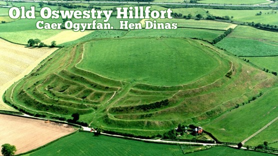
Photo from: The Heritage Trust Old Oswestry Hill Fort Under Threat

*

The photo above shows (along the top edge) how close the town is to the fort. The farm complex in the upper left-hand corner, nearest the hill fort, is one of the sites allocated for upmarket housing. Hill Fort Close, Multivallate Avenue anyone?

Below is the view from the other direction, showing the proposed developments. These sites (in pink) are outside the town’s present development boundary. Usually there can be no development outside a development boundary, unless a good case can be made for an exception site for affordable houses. On such sites, houses must remain affordable in perpetuity and are thus normally managed by a housing association or social landlord. So, you may well ask, how come the environs of this hill fort are suddenly under threat, and not from affordable, but from upscale market housing?

Os28

*

SAMDev – who’s heard of it?

In Shropshire we have a thing called SAMDev (a nasty-sounding acronym standing for site allocation and management development). Shropshire is one of Britain’s largest counties, mostly rural and agricultural, but with light industry and retail zones on the edges of market towns like Oswestry. SAMDev is a response to National Planning Policy which enshrines the concept of presumption in favour of sustainable development. Spot the weasel word here.

Oswestry Map

For the last two years Shropshire Council has been ‘consulting’ (theoretically with the communities concerned) on areas of land outside existing development boundaries and identifying locations for housing and employment growth up to 2026. The final plan will be produced by the end of this year and it will be available for public scrutiny before going to an independent assessor.

As part of this process, land owners and developers have been invited to put forward their own development proposals. In other words, SAMDev is rather like a county-wide preliminary planning application. Developers are thus in negotiation with Council planning officers throughout this process. This usually happens anyway with any large development proposal.

This means that when a formal application is finally submitted, it is likely to be passed by the Planning Committee with little argument. The Planning Committee is made up of councillors, people who may have little understanding of planning matters. They rely on the reports presented to them by planning officers. It is the officers who are compiling the SAMDev document.

Although this entire process is available for public scrutiny (all draft plans including individual communities’ Place Plans are on Shropshire Council’s website)  I think it’s safe to assume that most people in Shropshire don’t know that SAMDev has been happening. They might have been invited to consult, but somehow they did not understand the invitation, or the implications of not responding. Most people have thus not participated in the consultation process.

The biggest problem is that most normal people do not understand the kind of words that planning  people use. I may be cynical, but is this not deliberate? What is clear is that inexplicable quantities of houses have been allocated for big and small towns throughout the county. SAMDev, through its provision of specific sites for specific purposes, is the means by which they will be realised.

*

A case close to home – Much Wenlock

In my small town of Much Wenlock the local landowner has offered up farmland along the southern and western boundaries of the town. This has enabled Shropshire Council’s Core Strategy to make an astonishing allocation of up to 500 new houses in the next 13 years – this in a flood-prone, poorly drained town of 2,700 people, where employment opportunities are poor, and the mediaeval road system is not fit for purpose, either for traffic or for parking. In other words, the town is already full, and its ancient centre cannot be changed, short of flattening it.

001 (3)

Shropshire Council’s Core Strategy states that Much Wenlock needs up to 500 new houses in the next 13 years, increasing the town’s footprint by another 50%. The town sits in a bowl with a river running through it. The development in the foreground is one of the newer ones. Its drains were apparently connected to the old town sewer instead of to the separate system for which it had approval. New developments like this have hidden costs for existing communities. This particular problem has not been rectified six years on from the 2007 flood that damaged up to 90 homes.

*

Development = Sustainable Growth?

The ensuing development fest that will be enabled once SAMDev is passed is seen as a means to stimulate growth. The argument seems to be that communities will die if they do not grow in huge tranches. But this is only a point of view, not an absolute truth. There are other models for sustainability, perhaps more meaningful ones. Besides, every community has its particular characteristics that might suggest other narratives; strategies that enable them to grow without necessarily expanding all over the landscape. Of course it is always easier, and presumably cheaper, to build over new ground than it is to reclaim old buildings and clean up brown field sites within existing settlements.  Perhaps this is the reason why Councils do not take over unoccupied homes in towns, even though they have the powers to do so?

*

Trading on the past

In places like Much Wenlock house prices are high because, to quote estate agents and developers, “everyone wants to live here”. People want the best of both worlds, a high-spec modern house with multiple en suites, but in close proximity to gentrified antiquity where people live in homes that be cannot double-glazed because of listed building regulations. The new-home dwellers perceive acquired value by association with the past, and are prepared to pay for it. The kind of properties envisaged for the upscaled farmyard site near Oswestry hill fort will doubtless command a premium for similarly nebulous reasons.

001 (2)

Much Wenlock – view towards the town centre, a ‘60s development on the far hillside.

*

In this way, then, developers trade on something that does not belong to them – the historic setting that is cared for and maintained by other people. Buyers buy into the connection, distracted by the ‘look of the thing’. It’s all rather Emperor’s New Clothes-ish. But then if student debt can now be sold on by banks as a commodity, perhaps heritage detraction can also be a tradable commodity. Communities should exact compensation directly from those developers whose poorly designed housing schemes erode the quality of their environment, whether visually or through added strain on existing infrastructure. (In places like Shropshire effective infrastructure provision does not precede any new housing development; nor, if Much Wenlock is anything to go by, does it follow it.) And I’m not talking here about the modest Community Infrastructure Levy (CIL) that developers must pay to communities to build the small but useful things like playgrounds and car parks that councils no longer provide. But something far more substantial.

*

How much for this ancient monument?

So what value do we set on a hill fort? Is it worth twenty million pounds say? Fifty? More? Perhaps august academic institutions around the world might invest in shares in our monuments for their scholarly worth, and provide us with the means to buy off developers, or at least keep them at a respectable and respectful distance.

And I am only half-joking here. It would not be so bad if developers in this country built wonderful, good quality eco-houses in versions to suit everyone’s financial capacity, but mostly they don’t. And in the case of Much Wenlock the cost of large new developments around the town has been high – homes flooded from backed up drains and flash-flood run-off.

*

Standing up for heritage

But where does this leave Old Oswestry and all those  who are campaigning against developing the nearby farmland?

Since the Guardian article, support has been gathering from across the country and beyond. You can follow the campaign at Old Oswestry Hill Fort on Facebook. But the problem is that there are only so many arguments  you can make against unwanted development, and they have to comply with planning law and the Local Authority’s Core Strategy. They include loss of amenity value, visual impact, access, safety and sustainability.

At present, planning laws and high property prices give all the power to developers. If planning authorities cannot base refusal on the strongest case, then developers will opt for a judicial review to get their way. This costs local authorities a lot of money, and so us a lot of money.  Developers’ planning consultants write letters to planning officers threatening legal action. You will find such letters in Council files. This is one reason why authorities cave in without a fight.

The heritage consultant’s impact report on the proposed development near Old Oswestry concentrates on view, THE VIEW of the development from the hill fort, and of the development looking towards the hill fort. The impact is considered to be negligible, but this again is a point of view. Housing developments also come with multiple cars, parking issues, garbage storage areas, satellite dishes, and people living their lives as they  might expect to do in their own homes. There is also the future to consider. The Trojan Horse concept is a familiar one in development: approval of one development in due course setting a precedent for the next one alongside.

*

So why protect our past?

One would hope that the land around the hill fort would remain as farmland; that the farm could be sold as a farm. Or it  might make a good visitor centre for the hill fort, using existing buildings. In reality there is no need to build anything at all in the vicinity of the hill fort. Better that Shropshire Council use its powers to take control of unoccupied dwellings in the town rather than sanction intrusion into the setting of a historic monument of  national importance.

After all, why would anyone think that this was a good idea? These ancient places are resorts, and in all kinds of ways. They feed our imaginations and spirits; for children they grow understanding of other times, and other ways of living: all things that in the end make us wiser human beings. And isn’t this the kind of development we really need? People development? And before we carry on building all over the planet, shouldn’t we stop to consider what we already have, and see if some creative re-purposing cannot shape un-used buildings and derelict sites for our future growth requirements? Or is this approach too much to ask of our elected representatives and public servants?

Copyright 2013 Tish Farrell

nxeHdjNTMMiNFPH-556x313-noPad1.jpg

SIGN HERE: Change.org petition against developing land below the hill fort

*

Find out about protecting your heritage at Civic Voice and Council for Protection of Rural England and join your local CIVIC SOCIETY

*

Related:

Petition to Shropshire Council at Change.org

Oswestry 21 Community Voices

Oswestry Eye

The Essential Oswestry Visitor Guide

Old Oswestry Hill Fort on Facebook

English Heritage Old Oswestry

The Heritage Journal Oswestry Hill Fort Under Attack

The Heritage Journal Old Oswestry Hill Fort: a campaigner asks – “why aren’t EH entirely on the side of the Public?”

The Heritage Journal Old Oswestry Hill Fort Safe?

The Heritage Journal Oswestry Hillfort “top level talks”: will those who care for it stand firm?

The Heritage Journal Oswestry Hill Fort: is it a forgone bad conclusion?

@ShropCouncil on Twitter

@EnglishHeritage on Twitter