Well, they do say an Englishman’s home is his castle. And for this English woman, this stronghold must obviously include the garden. At least I like to think the garden is my domain; my own small fiefdom.
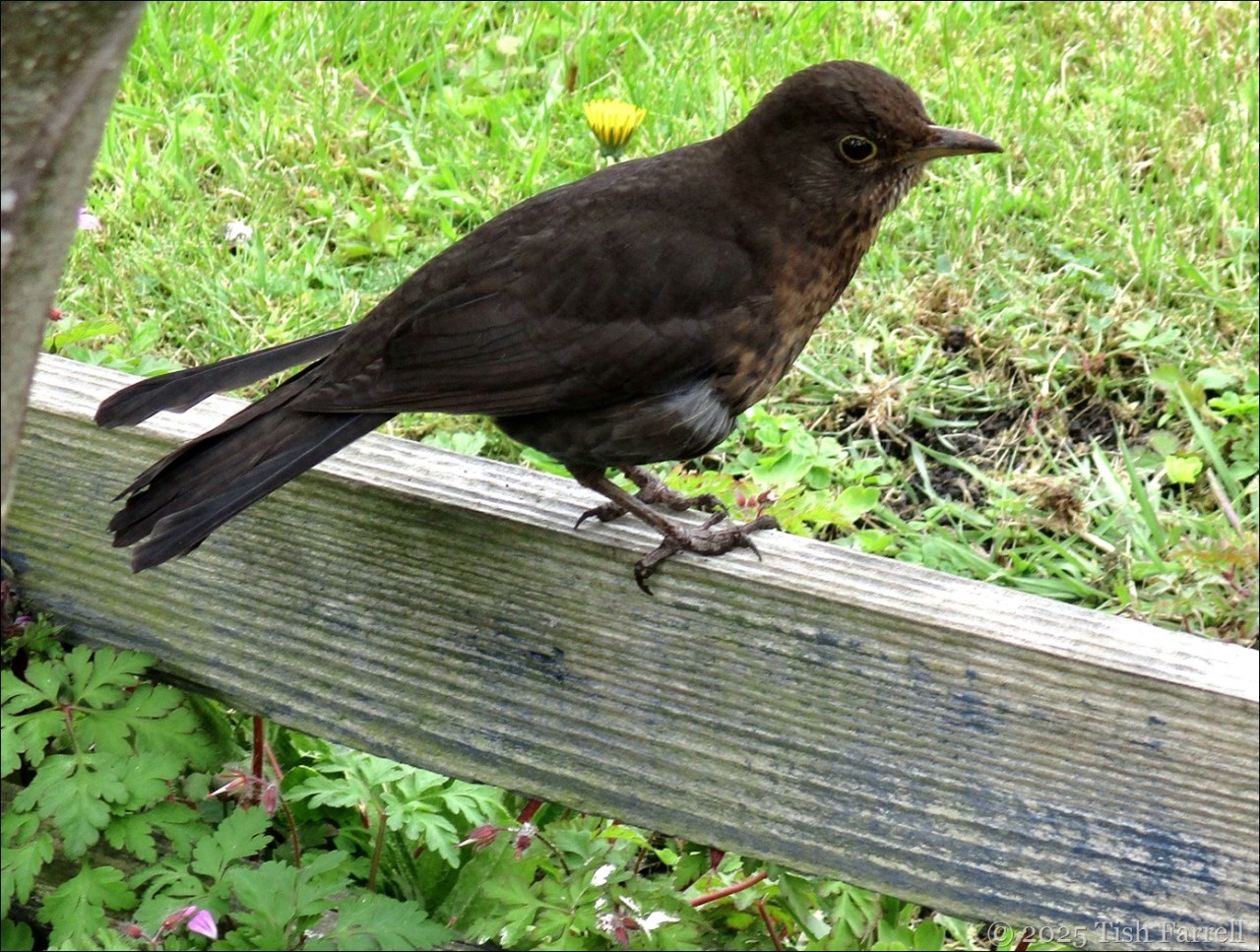
The wildlife, of course, has other notions. This mama blackbird, for instance, is quite sure my purpose in life is to provide her with fresh feeding stations. As soon as I begin work in the garden she’s there, poised to snatch a worm or grub. If I do not provide quickly enough, she fixes me with that beady eye, and starts her own digging. This has led to us falling out somewhat. I’ve had to net all my vegetable beds to stop her rooting out my seedlings.
But she did keep me company while I cleared the boundary wall with our neighbour’s garage. It was a horrendous job, hacking out ingrowing and overgrowing hypericum (Rose of Sharon) that years ago had been planted along the top of the wall, and since turned itself into a stretch of brutal anti-tank wire, while inviting Spanish bluebells, ash trees and willow herb to join in the fray.

I’d been tackling the job on and off since last summer. But now it’s done.

I’ve planted the road end with a couple of trailing blackberries designed for hanging baskets and also some foxgloves which had grown themselves in the back garden. As for the rest, for this year I’m thinking of putting in various kales and perhaps courgettes; nothing permanent in other words. I’ve discovered that hypericum shoots and roots from the tiniest scrap of itself, so it will probably take a few seasons to clear the bed.
Meanwhile mama blackbird has been well fed, and the feeding clearly paying off. Two days ago, while planting a hornbeam sapling to fill a gap in our rear hedge of horrors, I had the sense of being watched. When I peered into the tangle of privet, holly and sycamore, there she was, sitting still as stone, on a very neat nest, looking straight back at me. I left her in peace.
As blackbirds go, I suspect she is rather elderly. Her tail feathers look more than a touch bedraggled. But she has us weighed up as non-threatening entities, choosing to nest right by the path that we use all the time. She is not afraid to leave it either, when she sees me with a spade. Yesterday, when I was unearthing some ash tree saplings further down the hedge, she was right there, just in time to gobble up a big juicy worm.

Male blackbirds don’t do nest duty, but I’m assuming this is papa. He’s taken to singing sweetly in the hawthorn tree just over the hedge. He shows up when I’m digging too, but not if mama is around. (She sees him off). He actually comes very close and tweets at me, if I’m not providing worms.
Earlier in the year it was the robin who would come nagging as soon as I set foot in the garden. He/she was especially pleased with operation dig-out-compost-bin, but now is perhaps too busy with egg minding to be around so much.


*
Other birdlife, as in pigeons, I’m not so pleased to see. They’re another reason for having netting all over the vegetable plots, though it doesn’t stop them from nibbling through the fine mesh if the plants grow too close to the edge. They like spinach, brassicas, chard, chicory, beetroot leaves, lettuce, young field bean leaves and lemon sorrel.


The garden is very much ‘a first draft’; there’s much to sort out (tidy) and much trial and error (given the lack of an actual plan). Next week a paling fence will start going up around the perimeter (from behind the greenhouse and round). It won’t be too tall but will create a boundary for fresh planting which might help focus this gardener’s mind.
For now we are enjoying the apple blossom, and especially the little tree which is flourishing between the compost bins, one open, one hot. I think it’s a Crispin. The black hot bin is not a pretty sight, but the mass of flowers is lovely and, in a spot of warmish afternoon sun, is alive with bee hum. Just look at the pollen sacs on the bees’ legs.


*
And there’s not only apple blossom. On the terrace wall we have tulips. They are presently looking rather glamorous:


So: spring is here in the Farrell domain aka Castle (also the locals’ name for the town), and in moments when the wind drops and you stand in the sun where the air is less frigid, it feels like it too. Cheers, fellow gardeners! Happy planting!
Six on Saturday: blackbirds, robins, bird defences, apple blossom, bees and tulips
copyrithg 2025 Tish Farrell


n")