

*
Barn roofs, gates, styles, fence- field- crop- and power-lines, pylons and pole shadows. Oh yes, and some bull rushes…

A brilliant sun-frosty morning and, so we’re told, the last of the super-cold days. But just the morning for a hike up to the dew ponds above the town.
I love this green lane, perhaps the remains of an ancient thoroughfare between settlements, this before the creation of the modern road system, or maybe even part of the old drovers’ routes out of Wales, shepherds and cattlemen driving their flocks and herds to markets in the English Midlands.
Bishop’s Castle was anyway an important market centre at least as far back as the thirteenth century, when the Bishops of Hereford ruled it from their castle at the top of town. Charters were granted for weekly markets and seasonal fairs to be held outside the castle walls.
On market days this now quiet track might well have been bustling with carts, farmers’ wives with their produce: ducks, geese, hens, eggs, butter, cheeses; farm boys on foot, driving pigs, goats, cattle and sheep to sell. Other traders too might have come this way: basket, hat and chair makers, dealers in songs, fortune tellers, herbalists, and street musicians.

The Long Mynd
*
At the top of the hill are some dew ponds. These are man-made pools, created in upland areas without natural water sources, to provide for grazing stock. Water then collects in them, either rain or field run-off. Some may date from the Neolithic period, that is 6-7,000 thousand years ago. Others may date from the Middle Ages or more recently in the 18th/19th centuries when there was still a high demand for wool. Much skill was required to make them. They started out as a saucer-shaped excavation, about a metre (3 feet) deep, and anywhere between 3-15 metres in diameter. This was then lined with straw, followed by an impermeable layer of puddled clay.

*
One of the dew ponds no longer in use for stock watering is in its own enclosed domain and filled with bull rushes.

*
There are many fine views all round from this point on the footpath; also another dew pond, not presently in use:


*
And in the field with the operational dew pond, lots of ewes waiting to have their lambs:

*
At this point we retrace our steps, although we could (if all of us were willing) follow the path for several more miles, taking a wide loop back into town. Instead, we head straight down the hill, watching the ribbon of fog flowing along the far valley from Clun towards Craven Arms. We’ve recently learned that this mist phenomenon, rather common in these parts, is also called brume.

*
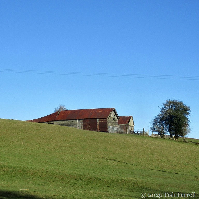
Finally at the foot of the hill by the Wintles, another favourite old barn:

*
And by now it was lunchtime so we called in at Tahira’s Chai Shop on the High Street for some delicious beef and vegetable samosas (also geometrical) plus lots of good chatting, topped off with (triangular) slices of Rose’s light-as-a-feather, and mouth-wateringly warm cardamom cake. None of which stayed on our plates long enough to think about taking photos. Sorry.

oh this is glorious – perfect winter’s day and how fabulous to have this on your doorstep.
I must find out if Wiltshire has a name for the mist in the valley as I see it regularly below me too
Many thanks, Becky. How many words for mist, I wonder.
hmmm now that sounds like an excellent post someone needs to write!
A lovely walk with some gorgeous views. Great to see some dewponds still in use. There were quite a few in Wiltshire where I spent part of my childhood.
Many thanks, Clive. As to dew ponds, I have to say I knew nothing about them until I met the Bishop’s Castle ones.
Such enticing photos and commentary. Especially that bulrushes shot.
Yes, the sun was catching them so nicely this morning, their seeds floating hither and thither.
What a perfect walk on a beautiful winter’s day.
It was, Jude.
“The last of the super-cold days” sounds like a challenge to Mother Nature, but hope for you it’s true!
That was asking for trouble, wasn’t it.
Such a lovely trip. The dew ponds are important for wildlife too, I imagine.
Yes, I’m sure the dew ponds are a valuable resource all round. I must try and visit them more often as we head into spring.
Dew ponds…new name but I like it.
I knew the name, but had no idea what they actually were until I did a web search.
What a beautiful walk. Thanks for sharing Tish.
Many thanks, Anne. It was a very lovely morning.
Beautiful photo capture of your morning walk! It’s so relaxing—I really enjoyed it. Thank you for sharing!
Happy to have you come along 🙂
Looks and sounds like the perfect walk for a bright cold winter day! I love the image of the low-lying mist, and ‘brume’ is a new word for me too 🙂 That old barn at the end is a gem for photography!
I love that barn, though I’m not sure how much longer it will be with us. On the other hand, there are a lot of anciently iffy structures around the town that seem to be hanging on.
what a novel , but extremely interesting , way to look at the landscape!
Thank you, Cora.
Trish, those photos are picture postcard – really enjoyed this morning walk.
*Tish
🙂
Many thanks, Flavia. Glad you liked the ‘postcards’ 🙂
What a lovely pastoral walk, Tish. I feel thorougly refreshed and ready for a chai and slice of cardamom cake!
Thanks for coming along, Mitch 🙂
I love the old barns and in particular, the ones atop the hill. Old England sometimes looks a lot like New England, except that finally, this year, we are actually have a real winter!
Yes, I can see that similarity with New England, Marilyn.
Our cities don’t look similar, but the land sure does. Lots of rocks. Lots of tree roots, old and new. Setting up anything requiring digging is always more work than anyone imagined including tent pegs for the tepee. Do you know it greater Britain was under ice in the age of ice? Our ice moved OVER New England and stopped in the middle of Queens in NY city. I lived very close to the point where the ice stopped. It was less than a quarter mile from home. Hilly land before it stopped, absolutely flat after its stopping point.
This isn’t information that everyone knows, but if you live in an area where it happened and you are curious, you’ll know — so I figured you’d know 🌍
Most of neighbouring Wales and Northern England was under ice, and the edge of field seems to have extended to the South Shropshire hills. It seems the nearby Stiperstones in particular were very much shaped by the glacial cycles of thaw and re-freeze which split the quartzite strata. But yes, the constant ebbing and flowing of ice over thousands of years before the final retreat doubtless left us lots of rumpled terrain. And then the melt water of unleashed rivers and streams would have made their own landscaping contributions. Lots of rubble.
Your photos capture the landscape beautifully.
Thank you, Jennie.
You’re welcome, Tish.
J’aime Bien !!
Merci!