
In 1992-1993, during the first years of Zambia’s multi-party democracy, we were posted to Lusaka, Zambia’s capital. Graham was charged with organising the distribution of European Union food aid to drought-stricken Zambians. (Part 1 is HERE and part 2 HERE and part 3 HERE)
*
It is early December 1992, barely two weeks into our Zambia posting, when Graham is despatched ‘on mission’, the European Union Delegation’s term for out-of-town business. He is told to attend a Monday morning meeting at a railway depot in Livingstone, some 300 miles south of Lusaka, a six hour drive away.

And the actual mission? To inspect a newly arrived shipment of maize from South Africa, via Zimbabwe, part of the 100,000 tonnes of food aid being brought in by the European Union. There has been talk of organised theft along the line of rail, of some local big man who has the power to divert trains to his own mill. It is thus important to check the consignment is intact.
Graham’s boss, Bernard, suggests he drives down the weekend before. He further suggests that I go too. It is a chance to see Victoria Falls, he says, and not to be missed. Later I suspect he is also being kind. We’ve scarcely adjusted to Lusaka living and he will not unnerve us by spelling it out: that Lusaka’s diplomatic quarter is a regular target for cross-border armed raids by unpaid members of President Mobutu’s Congolese army.
But on the Saturday morning as we leave the city under big skies, I’m not thinking about this; only of the journey ahead, of what we might see.
*
Once out of the city we head ever onward on the South Road. The single carriageway is wide and straight with few pot holes, and for the most part empty of traffic. After nine months of bumping along the ragged tracts of the Nairobi-Mombasa highway, stuck behind fumy trucks, it is sheer luxury. On either hand the savannah woodland runs green and lush and reminds me more of central France than of Africa. At Kafue we cross the wide expanse of the Kafue River, wooded uplands all around. But as I find later, this is the only significant landmark until Livingstone some five hours later.

A view of Zambian savannah miombo woodland, Southern Province
*
We pass through neat small trading centres – Mazabuka, Monze, Kalomo, Zimba. Sometimes we glimpse thatched roofs through the roadside vegetation. Sometimes there are lads holding out fistfuls of mushrooms, their caps big as dinner plates. But over all there is a sense is of quietness, an undramatic treescape sparse in humanity.
And then we’re in Livingstone, once Zambia’s capital, back in the days when Northern Rhodesia was a British Protectorate. In 1992 it strikes us as little more than a village. Its wide main street has a colonial air; all is neat; tree-lined pavements, arcaded stores; whitewashed, zinc-roofed, verandaed bungalows. When we check into the Intercontinental Hotel the time-warp feeling thickens. We are served afternoon tea on the tree-shady lawn, watched by ducks, guinea fowl and vervet monkeys.
By now I can wait no longer. The light may be poor, the sun blanked out, but there’s a world wonder to see, and the hotel’s garden path takes us right there…

*
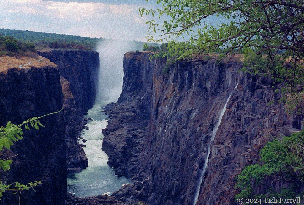
I don’t know whether to laugh or cry. It is too hard to absorb, this bare basalt cliff. The mighty Zambezi reduced to a trickle.
The long drought has much to do with it. But Zambia also abstracts large quantities of water to run its hydroelectricity scheme. Graham then tells me the best view of the Falls is on the Zimbabwe side of the cataracts, and that if we’d remembered to bring my passport we could have walked over the bridge to see them.
Ah, well. Another time perhaps. We walk along the path beside the waterless precipice, but this alien landscape soon has me thinking of Tolkein’s Mordor; I expect the eye of Sauron to burn through the cloud any second. We give it up and go back to the hotel.
")
The Falls as seen by David Livingstone in 1855. Engraving from Missionary Travels and Researches in South Africa 1857
*
It was David Livingstone who named the Falls after Queen Victoria. This was in 1855, and probably he was the first European to clap eyes on them. Of course they already had local names, Mosi-oa-Tunya, the smoke that thunders, being the Tonga people’s name for them. These somewhat reclusive farming folk inhabited much of the Zambezi Valley including the portion now occupied by Lake Kariba. It’s pleasing to learn that the UNESCO World Heritage citation at least gives precedence to the Tonga name.
*
In theory our hotel room has a river view, but all we see is a vast expanse of dry bed with odd clumps of palm trees and scatters of huge boulders. But on Sunday afternoon, under a bright sun, I notice people picking their way across. I persuade Graham we should join them.
We’ve hardly started out when a boy appears from nowhere and offers to guide us ‘to the best Falls’ viewpoint.’ And so we follow, but it’s not easy going, picking our way around oily pools and stagnant crevices, clambering through a maze of mammoth boulders, trying to ignore piles of fresh elephant dung.
We are so busy watching our feet we don’t notice the storm clouds gathering. And when I do, I’m suddenly nervous. I’ve read about flash-floods engulfing dried up river beds. I keep glancing upstream as if that will do any good. I worry, too, about rounding a boulder as big as an elephant and meeting an actual elephant.
Then the rain comes and that’s all I can think of – the fat freezing drops that stab the skin. (How can African rain feel so cold?) We follow the boy to cover, crouch under trees on Livingstone Island, the very spot from where the explorer had first viewed the Falls in 1855 (see the engraving: island in the foreground). For ages we crouch with the boy under dripping trees until, thoroughly cold and soaked, Graham asks him if the good view is much further.
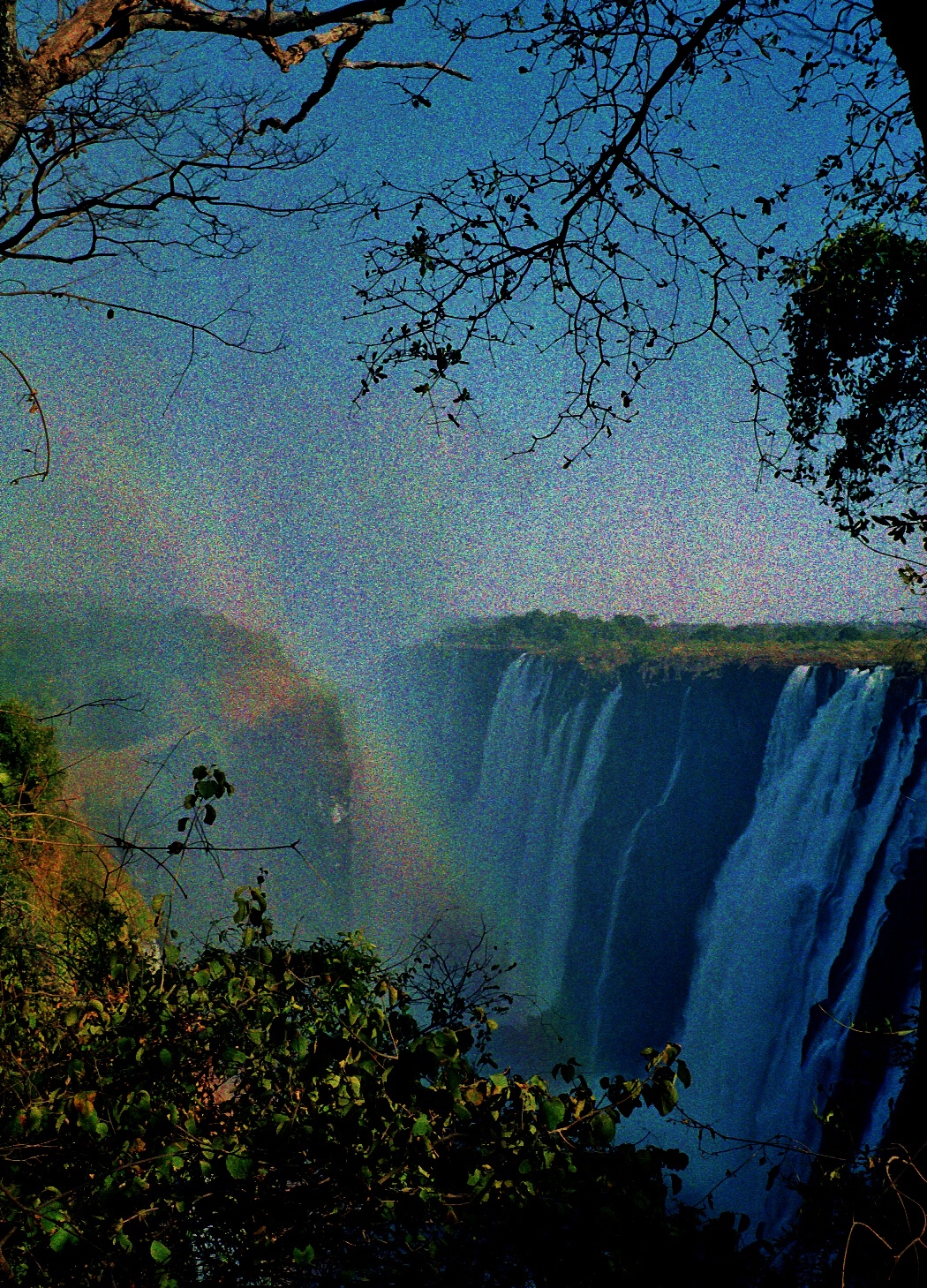
No, no, it is close by. We make a final dash. And here it is. The view:

*
Not much to see with spray rising up and rain pouring down. Except there we were on the knife-edge with a 300 foot drop below. I quickly take this photo, and stow my camera. Then hold my kanga-wrap (which I’d brought to keep off the sun) over my head to stem the downpour. And it’s then a sudden gust of wind snatches the sopping cotton. I feel the slight lift and step back in shock. I’ve had more than enough of Mosi-oa-Tunya.
So has the boy. We turn to see him sprinting away without waiting for a tip, and now I really am worried. Leaving without his kwacha? What does he know that we don’t? Watching him go, my heart sinks. The hotel looks very far away, the boulder-strewn riverbed between us and it, increasingly nightmarish. Overhead the sky is black, now and then fractured by great shafts of fork lightning. We slip and slide on wet rocks. More phantom elephants. More imaginary flash floods. More scrambling out of megalithic cul de sacs.
Of course it’s all panic and little substance. After a hot shower and a bottle of Mosi beer back at the hotel, it seems like a great adventure, though we do wonder if the part of Livingstone Island where we’d sheltered was in Zambia or if we’d entered Zimbabwe without the necessity of passports.
That night I am taken ill, probably the start of an amoebic assault that is later diagnosed in Lusaka. And so the next day when Graham has to visit grain depots, first in Livingstone, and then two Red Cross grain stores on the way back to Lusaka, I am happy to sit in the car and doze. It will be another seven months before I finally see the western cataract of Mosi-oa-Tunya.

Maize consignment safely arrived in the Livingstone depot
Copyright 2024 Tish Farrell


")