

We inhabitants of Great Britain, that one-time source and bastion of Empire, somehow take it for granted that other people’s geography should be named after our explorers, our lords and our monarchs. It was part and parcel of the colonizing process, this laying claim to territory, the ‘making it ours’ rather than theirs, the indigenous inhabitants’. Also, much as a head-hunter gains spiritual power by consuming the brains of his enemy, so explorers, lords and monarchs accrued grandeur by bestowing their names on natural-world-wonders. It was one way of acquiring grand-scale permanence over frail bodily transience. Some might say it was a form of megalomania.
All of which is to say that the photo above shows one of the most famous examples of colonial misappropriation – the great southern African cataracts of Victoria Falls. They were ‘discovered’ by missionary, David Livingstone, in November 1855. This was in the days before the British map-makers had staked out the colonial territories of Northern and Southern Rhodesia, (named after the mineral-hungry Cecil Rhodes), and now known (respectively) as Zambia and Zimbabwe.
Livingstone is thought to be the first European to set eyes on the falls, and his presence is commemorated both in the name of Livingstone Island, just above the falls, and in the town of Livingstone on the Zambian side of the cataracts.

Livingstone Monument
But the fact remains that when Livingstone arrived this, the largest falling curtain of water in the world, already had at least one very fine name. The rainbow spray from the toppling cascades rises like smoke that can be seen for miles, and the Zambezi, as it drops through 110 metres, simply roars. And so it is fittingly known by the indigenous Tonga people as Mosi-oa-Tunya, the smoke that thunders. Also fittingly, and by way of restitution, this is also the name that UNESCO puts first in its World Heritage Site citation for the falls.

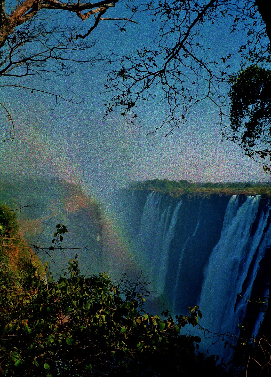
The falls from the Zimbabwe side at Victoria Falls town. The spray is a challenge to the the photographer.
*
The photo below shows the falls from the Zambian side. The rains had been poor when the shot was taken, and much of the water from the Zambian side of the Zambezi is anyway abstracted for industrial purposes. It is hard to convey the scale, but it shows well how the Zambezi has cut through the basalt plateau over which it flows. Over the last hundred thousand years the river has repeatedly carved out new gorges, wearing down cracks of softer sandstone within the basalt and creating a zigzag of massive fissures. The current falls go over the eighth gorge, but there are already signs that the ninth is beginning to form.
I have the foolhardy distinction of almost hang-gliding off the falls’ knife-edge courtesy my kanga-wrap, just then being used as an umbrella. G had business in Livingstone and we were staying in a hotel near the river, or I should say near the absence of river. I saw people walking across the waterless river bed towards the Zimbabwe side of the falls, and one Sunday afternoon, urged G. to set off on an outing. In no time we had a young Zambian boy offering to be our guide. He led us through a maze of huge boulders and oily stagnant pools. At one point I noticed fresh elephant droppings and fully expected the massive stones to transform into pachyderms, since that’s the sort of thing elephants do. All around the sky was turning from brilliant blue to a steely grey. I forgot about elephants and thought of flash-floods instead. I was beginning to wish we had not come.

But the boy pressed on, heading we later discovered for Livingstone Island. He had promised to show us the best place to view the falls. And so we followed. And then came the deluge. In seconds we were soaked to the skin by very cold, hard rain. When I looked back across the river, our hotel seemed very far away, and the empty river bed so very wide. We ran after the boy into the trees on Livingstone Island, and there we huddled under the dripping vegetation. Time passed. And more time passed. We grew colder and wetter.
Finally, when there was no sign of the rain letting up, G. asked the boy how far was this viewpoint. Oh, not very far, he told us. We followed him out into the driving rain. And sure enough, in a few paces, there we were on the knife edge. I held my kanga high above my head, fly-sheet style, in a bid to fend off the downpour. But as I craned over the precipice, the wind gusted and I felt the threatening lift as it filled the kanga…
After that there could only be a swift retreat. Shaken by my close shave with the abyss, I turned for the distant shore and tried to run. But the rocks were slippery, and every boulder looked like an elephant, and the more it rained the more I glanced upstream for that wall of rushing water. By now our guide had disappeared. I don’t think we had even given him a tip, and that was even more worrying. To leave without his kwacha? What did he know that we did not?
Of course it was all panic and no substance. After a hot shower and a bottle of Mosi back at the hotel, it seemed like a great adventure, though we did wonder if Livingstone Island was in Zambia or in Zimbabwe, and if, in the rainstorm, we had become illegal immigrants into Zimbabwe. Of course we hadn’t, but it added a little more spice to the story.

")

The Victoria Falls bridge, built in 1905 in a bid towards fulfilling Cecil Rhodes’ dream of the Cape to Cairo railway line. He insisted it was built where the falls’ spray would fall on passing trains.
Related:
Sun, Steel and Spray: A History of the Building of the Victoria Falls Bridge by Peter Roberts
Where’s My Backpack Ailsa’s Travel Theme: Height
More takes on height:
http://suejudd.com/2013/10/04/weekly-travel-theme-height/
http://cosytravels.wordpress.com/2013/10/04/travel-theme-height/
http://laavventura.wordpress.com/2013/10/04/travel-theme-height/
http://bastet1952.wordpress.com/2013/10/04/travel-theme-high/
http://sustainabilitea.wordpress.com/2013/10/04/travel-theme-height/
© 2013 Tish Farrell

One of my favourite places in the world, thank you for sharing.
Thanks, Joan. It is a tre-mendous place, isn’t it.
Absolutely.
Tish, your adventure at The SmokeThat Thunders had me gripping my seat. I have a growing fear of heights so I was full of concern for you during your ordeal in the downpour. As you said, once back at base it all seemed like a bit of fun. I wonder if you ever saw your disappeared guide?
Thanks
Hope I didn’t induce too much anxiety, Tony. And no, we never saw the guide again. He probably thought he hadn’t done his best by us, getting us caught in a rainstorm, tho it wasn’t of course his fault. Thanks for reading.
Brilliant story; and such beautiful photos. I’m glad that UNESCO has recognised the indigenous name first (apart from anything else it’s relevant and sounds better!!!). Re-claiming names is so important for cultural pride and survival, and I’m glad to say it’s happening more and more in NZ which is now, officially I think, Aotearoa New Zealand (and if it’s not, it should be). So glad your impromptu attempt at hang-gliding didn’t actually work.
Thanks, Su. As you say, apart from anything else, indigenous names are often far more interesting, and a story in themselves.
Terrific post. I believe I saw on a TV Nature show the lookout you were talking about. Glad you made it out to tell the tale.
That first shot is truly magic! It’s the view that always fills me with awe – smoke that roars or not, this place is more than just water tumbling down to the next level! 🙂
Thanks very much.
Every Columbus Day, my Native American friends are in a really bad mood all day long. Thanksgiving, too. Meanwhile, let’s hear it for Americus Vespucci.
Hi Marilyn. Thanks for reading.
Wonderful information, Tish. I enjoyed every word! 🙂
Thank you so much, Celestine.
Thank you, Celestine.
“The Smoke that Thunders” – sounds like an American Red Indian chief – I would want to be called that, beats Victoria 🙂 Another very interesting post Tish.
Thanks, Robin. Yes, put like that Victoria seems a very silly name for such dramatic geology.
Nice shots, Tish. Good choice for the theme!
Thanks, Stefano.
A pleasure seeing your photographs and learning a bit of history. We have a King George running right through the center of town, and to tell you the truth… I wouldn’t want to change the name. I have too many associations with that street. Moreover, it reminds us of time gone by. But I can well understand why others might want to change the names now and then.