A Bronze Age Circle And Some Mystic Brume

Mitchells Fold and brume

It’s a year or so since we last visited Mitchell’s Fold stone circle. I’m not sure why it’s taken so long to go back there. It’s only six miles from home and such a fine spot, sitting high on Stapeley Hill, with the Stiperstones to the east, Corndon Hill to the south and Wales rolling out in the west. Somehow we had let the summer go by when a sundowner visit would have been perfect for capturing light, communing with ancestors and gazing out on those wide Welsh vistas.

As it was, we waited until late September. And so last Friday, and well before coffee time, in hopes of some good light, we set off. The sky was clear, the sun brilliant and the air autumnally crisp. As we drove out of Bishop’s Castle, I conjured the landscape photos I would take up on the hill; those views into Wales…

path to Mitchells Fold

Except when we set off on foot up the Stapeley Hill track I soon saw I wouldn’t. Westerly vistas were off.

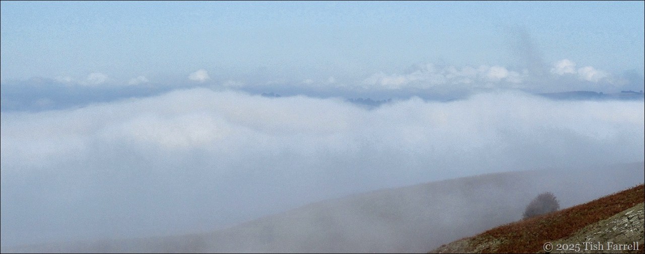
The uplands might be bathed in sunshine, but the low lying reaches had been invaded by rivers of mist, also known in literary circles as brume. We watched as this mysterious atmospheric phenomenon flowed by, whiffling up hillside clefts and gullies, some of its manifestations distinctly pink. At closer quarters you could see through it as if looking through gauze.

Brume

*

Seen in monochrome setting, there’s almost the sense of spray, as in breakers crashing against a rocky cliff-face…

Brume monochrome

Of course this all added a frisson to the mystery of ancient stones.

I’ve written about them several times, including in a much older post Witch-catching in the Shropshire Wilds which mentions the myth associated with the place. But very little is known of them other than there were once 30 or so standing (now only 15 and some of them are recumbent.) And that they were sourced locally and hauled in place over 3,000 years ago. We can guess, too, that this was a place of great significance to local people (temple or gathering place?) for we know, too, that nearby hills (Corndon, the Stiperstones) have on their flanks many remains of Bronze Age burial cairns. There is also a lone standing stone and a supposed robbed burial cairn not far from the circle.

A landscape, then, of many meanings; the kind of meanings where sacred and profane coalesce, the subtleties of whose interconnectedness we offspring of industrial culture often fail to grasp, confusing the sacred with dogma. 

Brume 2

Around the stones, there are traces of more recent human doings. You can see them in the photos: the remnant ridges and furrows of a mediaeval field system. And also running through the middle of the circle, the ruts made by carts and, in particular, the stage coaches that are said to have run this way between our county town of Shrewsbury and Aberystwyth in mid-Wales. Can you imagine?

In a way, I find this last historical glimpse more exciting than the stones. Just think how it would be, racketing around in a draughty coach, being hauled over this bleak hill on a grey winter’s day, some real fog closing in and looking out on these standing stones…it could be a scene from Jane Eyre.

Mitchells Fold coach route

Mitchells Fold coach road

*

For now I’ll leave you with some more non-wintery views:

Mitchells Fold and Corndon Hill

Stiperstones

towards Bishop's Castle

*

Copyright 2025 Tish Farrell

Brume header


This Morning’s Walk With Some Rural Geometry

IMG_6696sq

*

Barn roofs, gates, styles, fence- field- crop- and power-lines, pylons and pole shadows. Oh yes, and some bull rushes…

IMG_6693ed

A brilliant sun-frosty morning and, so we’re told, the last of the super-cold days. But just the morning for a hike up to the dew ponds above the town.

I love this green lane, perhaps the remains of an ancient thoroughfare between settlements, this before the creation of the modern road system, or maybe even part of the old drovers’ routes out of Wales, shepherds and cattlemen driving their flocks and herds to markets in the English Midlands.

Bishop’s Castle was anyway an important market centre at least as far back as the thirteenth century, when the Bishops of Hereford ruled it from their castle at the top of town. Charters were granted for weekly markets and seasonal fairs to be held outside the castle walls.

On market days this now quiet track might well have been bustling with carts, farmers’ wives with their produce: ducks, geese, hens, eggs, butter, cheeses; farm boys on foot, driving pigs, goats, cattle and sheep to sell. Other traders too might have come this way: basket, hat and chair makers, dealers in songs, fortune tellers, herbalists, and street musicians.

IMG_6697sq

The Long Mynd

*

At the top of the hill are some dew ponds. These are man-made pools, created in upland areas without natural water sources, to provide for grazing stock. Water then collects in them, either rain or field run-off. Some may date from the Neolithic period, that is 6-7,000 thousand years ago. Others may date from the Middle Ages or more recently in the 18th/19th centuries when there was still a high demand for wool. Much skill was required to make them. They started out as a saucer-shaped excavation, about a metre (3 feet) deep, and anywhere between 3-15 metres in diameter. This was then lined with straw, followed by an impermeable layer of puddled clay.

IMG_6725sq

*

One of the dew ponds no longer in use for stock watering is in its own enclosed domain and filled with bull rushes.

IMG_6716sq

*

There are many fine views all round from this point on the footpath; also another dew pond, not presently in use:

IMG_6707sq

IMG_6709sq

*

And in the field with the operational dew pond, lots of ewes waiting to have their lambs:

IMG_6724sq

*

At this point we retrace our steps, although we could (if all of us were willing) follow the path for several more miles, taking a wide loop back into town. Instead, we head straight down the hill, watching the ribbon of fog flowing along the far valley from Clun towards Craven Arms. We’ve recently learned that this mist phenomenon, rather common in these parts, is also called brume.

IMG_6729sq

*

Finally at the foot of the hill by the Wintles, another favourite old barn:

IMG_6734sq

*

And by now it was lunchtime so we called in at Tahira’s Chai Shop  on the High Street for some delicious beef and vegetable samosas (also geometrical) plus lots of good chatting, topped off with (triangular) slices of Rose’s light-as-a-feather, and mouth-wateringly warm cardamom cake. None of which stayed on our plates long enough to think about taking photos. Sorry.

#GeometricJanuary Day 16